Introduction
 Buldhana district, with an area of 9,680 sq km is positioned in the Amravati division of the state of Maharashtra in western India. The district lies at a distance of around 500 km from the state capital, Mumbai. The place is widely known for being home to the world`s largest hyper-velocity meteorite impact crater in basaltic rock, the Lonar crater. The district consists of five subdivisions, namely Buldhana, Mehkar, Khamgaon, Malkapur, and Jalgaon-Jamod. There are thirteen talukas- Buldhana, Chikhli, Deulgaon Raja, Malkapur, Motala, Nandura, Mehkar, Sindkhed Raja, Lonar, Khamgaon, Shegaon, Jalgaon Jamod and Sangrampur. Buldhana is believed to have been a part of the kingdom of Vidharaba mentioned in the Mahabharata. Since then, it has been under the rule of a number of different dynasties before it fell into the hands of the East India Company.
Location of Buldhana District
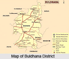
Buldhana district is located in the central portion of the state of Maharashtra. Akola, Jalgaon, Jalna, Parbhani districts are the adjoining districts to the East, West and South respectively. Nemad district of Madhya Pradesh lies to the North. The district of Buldhana lies between the North latitudes of 19 degrees 51 minutes and 21 degrees 17 minutes and east longitudes of 75 degrees 57 minutes and 76 degrees 49 minutes. The district is bounded by the state of Madhya Pradesh on the north, the Akola district and the Washim district in the east, the Parbhani and the Jalna districts to the south, and to the west lie the Jalna and the Jalgaon districts. The district Head Quarters is at Buldhana which is connected to all thirteen talukas of the district by state highway. The state capital of Mumbai is 450 km to the west and is connected to Buldhana by road.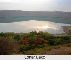
Administration of Buldhana District
District Collector is the head of District Administration in Buldhana. One Additional District Magistrate assists him with eight deputy collectors to run the administrative machinery. Five Sub Divisional Officers work at the division level to distribute power at the local level. There are thirteen Tehsil headquarters assigned to the five Sub Divisions. Each one has a Tehsildar as the administrative officer. The entire department of a Tehsildar works in accordance with the land record system to serve the farmers and land holders. Tehsils are divided into circles and out of this a group of 3-4 circles are handled by the Naib Tehsildar. They enjoy all the powers of a Tehsildar for their assigned circles.
Demography of Buldhana district
Buldhana District has a population of 2,232,480 of which 1,144,314 are males and 1,082,014 are females (as per the 2001 census). The literacy rate is around 76.14 percent, which is considerably higher than the national average literacy rate
Culture of Buldhana district
Folk arts and crafts abound in the district, one of the foremost aspects of the culture of a district. The folk arts prevalent in the district are Bhajan, Keertan and Gondhal. A fair is held every year in the district on the occasion of Ram Navami.
History of Buldhana District
 It is believed that Buldhana district, along with the rest of the erstwhile Berar province, was part of the legendary kingdom of Vidarbha that finds mention in the Mahabharata. This district also constituted a part of the Mauryan Empire during the reign of Ashoka(272 to 231 BCE). The province of Berar later came under the regulation of the Satavahana dynasty (2nd century BCE-2nd century CE), the Vakataka dynasty (3rd to 6th centuries), the Chalukya dynasty (6th to 8th centuries), the Rashtrakuta dynasty (8th to 10th centuries), and the Chalukyas again (10th to 12th centuries), and finally the dynasty of the Yadavas of Devagiri (late 12th to early 14th centuries). A period of Muslim rule began in the district when Ala ud din Khilji, Sultan of Delhi, occupied the area in the early 14th century. The district was part of the Bahmani Sultanate, which became separate from the Delhi Sultanate in the middle of the 14th century. At the end of the 15th century, the Bahmani Sultanate broke up into smaller sultanates, and in 1572 Buldhana district along with the rest of Berar became part of the Nizam Shahi sultanate, based at Ahmednagar. The Nizam Shahis surrendered Berar to the Mughal dynasty in 1595. As Mughal rule began to proliferate at the start of the 18th century, Asaf Jah I, the Nizam of Hyderabad took possession of the southern provinces of the empire (including Berar) in 1724, forming an independent state. In 1853, the Buldhana district together with the rest of Berar came under the administration of the British East India Company. Berar was divided into East and West Berar with Buldhana district being included in West Berar.
Geography of Budhana District
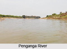
The Buldhana district experiences a tropical type of climate. It lies in the Tapti River and Godavari River basins. Purna River is a tributary of the Tapti River while Penganga River and Kadakpurna River are tributaries of Godavari River. The main crops grown in the district are cotton, jowar, oilseeds, soyabeans, sunflower and groundnut. The district has many minor and medium sized irrigation projects. The important ones are Nalganga and Vaan. The foremost industrial areas are at Khamgoan and Malkapur and comparatively smaller industrial areas at Chikhli, Buldhana, Dasarkhed, Deoulgaonraja, Mehkar, Sangrampur and Lonar. The railway stations in and around the Buldhana district are Khamkhed, Malkapur, Wadoda, Chandur, Biswa, Nandura, Kumgaon, Burti, Jalamb Junction, Khamgaon, Shegaon, and Nagzari. The district is connected to other places by a network of roads. The airport nearest to the district is in Aurangabad, which is at a distance of around 150 km.
 Geography of Buldhana district encompasses the central portion of the state of Maharashtra. The districts of Akola, Jalgaon, Jalna and Parbhani lie adjoining the district of Buldhana. The Nemad district of the Madhya Pradesh is to the North. The district lies between the north latitudes of 19 degrees 51 minutes and 21 degrees 17 minutes and east longitudes of 75 degrees 57 minutes and 76 degrees 49 minutes. The district Head Quarters is at Buldhana which is connected to all thirteen talukas of the district by state highway. The state capital of Mumbai is 450 km to the west and is connected to Buldhana by road.
The climate of Buldhana district is generally dry and hot. Buldhana town itself i.e. district headquarters, has a comparatively cool weather and is considered to be the most pleasant place in district. The general climate of the district is characterised by hot and dry summers and cold winters with the seasonal variation in the temperature being pretty large. Hailstorms are common during February to April and also during the post monsoon period from November to January. The district gets rain mainly from the south west monsoons. The rainfall period is from June to September. However rain generally falls in the months of June and July up to the end of October. The district falls under the assured rainfall zone and average rainfall ranges from 500 to 900 mm.
From the geological point of view, there are no major mineral ores. Some kinds of salts and lead are observed in Lonar Crater but they have not been commercially exploited. The major rock is Basalt hence the major soil type is Regur soil or Black cotton soil. This is found predominantly in the Jalgaon, Jamod, Sangrampur, Nandura, Shegaon, Malkapur, Khamgaon areas. The Deccan trap covers 80 percent of the total area of the district, and 20 percent is covered by alluvium soil. All the talukas except Jalgaon Jamod, Sangrampur and part of Shegaon talukas are covered by the Deccan trap. The trap is classified in, the following categories.1) Weathered basalt of all types 2) Fractured and Jointed basalt 3) Vesicular geologic basalt 4) Compact massive basalt.
In basalt ground water occurs in joints, fractures and other zones of weakens, which serve as loci for the accumulation of groundwater. Percolation of ground water is controlled by the density of the joint, fractures, and vascules in the Deccan trap. The flow is separated by a tine gap deposition which is known an intertrappens. In the district redboles occur as a major intertrappen which play a very distinct role in the local behaviour of groundwater.
Tourism in Buldhana district
 Tourism in Buldhana district includes visiting places of both religious as well as historical significance. There are a number of places located here where the tourist can go to get and idea of the district`s rich historical traditions. One of the most famous tourist locations here is the Lonar crater. It is among one of the five largest craters in the world, and the third largest saltwater lake in the world. There are many places of interest located in and around the crater as well. Among the religious places located here are the Hanuman murti, Shri. Sant Gajanan Maharaj and Sailani Baba`s Dargah. These various tourist attractions in the district of Buldhana are discussed below.
Shri. Sant Gajanan Maharaj, Shegaon
Shegaon is famous for the Samadhi of Shri Gajanan Maharaj - a mystic saint as popular as Saibaba of Shirdi. Shri Sant Gajanan Maharaj made his divine appearance in the year 1878 and enlightened millions. He attained samadhi on Bhadrapad Shukla Panchmi 08-09-1910. The Samadhi Sthan (Temple) is visited by millions of devotees from far and near. A large number of pilgrims can be seen here, some coming from various parts of Maharashtra, and across India. Allegorically, Shegaon can be described as the Pandharpur of Vidarbha. Thousands of devotees pay their respects at the Samadhi every Thursday, which is regarded as a special day. A beautiful temple of Lord Rama has also been constructed in the premises of the shrine. Fairs are held here at Shengaon on Ram Navami in Chaitra and on Rushi Panchami in Bhadrapada month of the Hindu calendar.
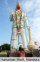
Hanuman Murti, Nandura
Lord Hanuman is the son of Pawan (Air) and Anjani (the woman of a highly spiritual native). Located here is the world`s largest statue of Lord Hanuman. This statue is 105 feet tall, and the girth of the chest is around 70 feet. The base is around 30 feet, and the tail and the arm measure around 70 feet and 25 feet respectively.
Sailani Baba`s Dargah
Sailani Baba wandered the forests and tamed many wild animals such as tigers, lions and other cats. His shrine is located in the Buldhana district of Maharashtra, near Aurangabad. The rich dresses worn by most saints are probably an artist`s imaginative depiction of the `rutba` or spiritual stage the saint had attained. Promises of offerings to the Saint are, therefore, made with various motives, and on fulfilment of the desires, the things promised, such as `galaf`, sweets, etc., are offered. The nearest railway station is Malkapur on the Mumbai-Kolkata main line of the Central Railway.
Lonar Crater
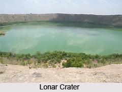 Lonar ranks amongst the world`s five largest craters and the third largest salt water lake in the world. Investigations reveal it to be around 50,000 years old. Lonar Crater is a huge bowl (roughly 7 kms in circumference and 1.6 kms in diameter) that has been carved out. Within the depression lies a saline lake. The crater was first discovered in the year 1823 by the British Officer, C.J.E. Alexander. The Lonar crater also finds mention in the ancient scripts like the Skanda Purana, Padma Purana and Ain-i-Akbari. During the days of Emperor Akbar, Lonar also housed a salt factory. There are a number of interesting places of tourist interest in and around the crater.
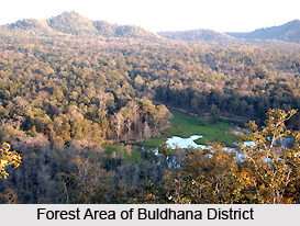
The small temple of Lord Vishnu and most others in the vicinity are constructed in the Hemadpanthi style i.e. without the use of cementing agents. While most in ruins and have been amended, only the ones that attract pilgrims have some resemblance to their original selves. Gomukh Temple, along the rim of the crater with a perennial stream is another interesting site. A fascinating sight is the presence of hundreds of peafowl which live inside the crater. The crater has potential as a bird sanctuary and one can also sight langoors, snakes, monitor lizard, mongoose, fox and deer.
Sindkhed Raja - Birth Place of Rajmata Jijabai
Sindkhed Raja, a small Taluka place in Buldhana district, situated 105 kms away from district headquarters Buldhana on the State Highway No. 183, is known world wide as the birth place of Rajmata Jijabai, the mother of the great Maratha warrior and king, Chatrapati Shivaji Maharaj. There are a number of monuments in this small township which owe their existence to Rajmata Jijabai and her father Lakhuji Jadhav. These monuments like Kalkat, Rang Mahal, Tomb of Lakhuji Jadhav, Palace of Lakhuji Jadhav, ancient temple of Neelkantheshwar and Rameshwar have great heritage and architectural value.


