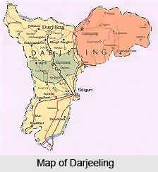
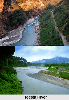
 Darjeeling district is situated within the state of West Bengal. The Hill areas of Darjeeling District are located within the Lesser and Sub - Himalayan belts of the Eastern Himalayas. The area is bounded by the Sikkim Himalaya in the north, the Bhutan Himalaya in the east and Nepal Himalaya in the west. The southern foothill belt is demarcated by a highly dissipated platform of terrace deposits extending along the east west axis. The inner belt is defined by a ridgeline stretching from the Darjeeling Hill to the west and Kalimpong Hill to the east, overlooking the southerly flowing Tista valley in between. Prominent rivulets contributing to the Rammam - Rangit basin dissipate the northern slope of Darjeeling Hills. The major rivers flowing through here are- Teesta River , Mahananda River, the Great Rangit, Mechi, Balason, Lish, Gish, Chel, Ramman, Murti and Jaldhaka river.
 The mean annual temperature fluctuates from 24 degrees Celsius in the plains and drops below 12 degrees Celsius on the ridge. During summer month the temperature reaches 16 degrees Celsius -17 degrees Celsius on the ridge and during winter drops to 5 degrees Celsius - degrees Celsius. There is no distinct relation between total rainfall and altitude. The annual total rainfall in Darjeeling town fluctuates between 1870-3690mm. The southern slopes of the ridges get much higher (4000-5000mm) precipitation than the leeward sides (2000-2500mm). The next main ridge, Tiger Hill gets 3000mm while to the north the Great Rangit valley receives about 2000mm of rainfall. Particular mention must be made here of one of the most harrowing episodes faced by the population in the mountains- landslides. This is a major problem faced here. Soil erosion, heavy rainfall, cropping practices affecting soil cohesiveness and many more causes can be attributed towards the same.
As regards the geology of the land, Darjeeling Hill area represents a unique geo- environmental perception. It is primarily composed of erosional landforms produced by southerly flowing streams, which have exposed a full cross section of different tectonic units. The form units are, however approximately the same throughout the hill area, having more or less uniform lithology, structure, climate, soil and vegetative covers. The contact between different groups of rocks is represented by thrusts, dipping at high angles towards north. There are various land formations found across the length of the Darjeeling Himalayas. These include Raised terraces, the Siwaliks, the Damuda series, Daling series and Darjeeling Gneiss.
The soils of Darjeeling Hill area have developed depending upon the underlying geological structure. But, in general the soils have been developed by both fluvial action and lithological disintegration. The basic soil types are yellow soils, red brown soils and brown forest soils. Red soil and yellow soil have developed on gneiss while brown on schists and shales. Coarse pale yellow to red brown soils are found on the Siwaliks while clayey dark soils are developed on Daling series. On the Darjeeling gneiss, very coarse-grained (50 percent -80 percent) particles are found. All the soils are definitely acidic in nature with the tendency to increase slightly in depth in most cases indicating the absence of bases.
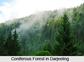 Forests abound in the Darjeeling Hill Areas. The four major forest types found here are-
Tropical moist deciduous forest (300-1000mts), Tropical evergreen lower montane forest (1000-2000mts), Tropical evergreen upper montane forest (2000-3000mts.),Temperate forest (3000-3500mts.), Sub temperate forest (above 3500mts.). The major portions of the forests are today found at elevations of 2000 mts and above. The area located in between 1000-2000mts is cleared either for tea plantation or cultivation. About 30 percent of the forest covers found in the lower hills are deciduous. Evergreen forest constitutes only about 6 percent of the total forest coverage. Shora robusta remains the most prominent species of Tropical moist deciduous forest along with heavy under growth. Tropical lower montane evergreen forests are found on steep higher slopes, where drainage condition is good; Dhupi (Cryptomaria Japonica) is a known variety. Tropical upper montane evergreen forests are found in the areas where high humidity along with dense fogs and less sunlight is available. Undergrowth is dense and contains Nettles, Raspberries, Ferns and bamboo. On the steep ridges, Rhododendron and bamboo are abundant.


