Home > Travel > States of India > History of Daman and Diu
History of Daman and Diu
During the early stage, i.e. from 8th to 13th century, Daman and Diu was part of Goa.

Share this Article:

During the early stage, i.e. from 8th to 13th century, Daman and Diu was part of Goa and during that time Goa was a stronghold of the Chowda Rajputs who were later expelled by Waghalas who in turn were expelled by Muslims in1330. They remained under the domination of Muslims for 200 years until the Portugese conquered it. The Portuguese ruled Goa for 451 years (1510-1961). Albuquerque entrenched himself in the Island of Tiswadi in1510. His successors dominated this territory for 4 ½ centuries in spite of opposition to the alien rule from the people within and outside the territory. When Bahadur Shah was attacked by Humayun he entered into an alliance with the Portuguese and allowed them to construct a fortress on the Island and keep up a fort there.

Fort of  Diu
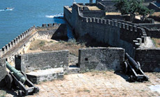
Later many attempts were made by the rulers of Gujarat to oust the Portuguese from the Fort of Diu. But their attempts never did succeed. The Treaty of 1543 finally confirmed the termination of Diu to the Portuguese. Dom Joao de Castro reconstructed the fortress of Diu after the siege. The Portuguese annexed Salcete and Bardez Talukas and the coastal areas, north of Bombay and the pockets of Daman and Diu by the middle of 16th century. In 1670, a band of Arabs of Muscat plundered the fortress. The other most important event that occurred in the history of Daman and Diu is the `Operation Vijay`, which happened before the midnight of December 16, 1961, ending the colonial rule.

Thus, Danman, Diu, and Goa became one political unit after liberation from the erstwhile Portuguese regime in 1961. It was in 1987, when Goa became a full-fledged state, that Daman and Diu was separated from Goa. Thereafter Daman & Diu became a separate Union Territory with effect from 31/05/1987. Daman is situated at about 12 km. from Vapi railway station and Diu is located at the southern most tip of Saurashtra near Veraval. Diu is about 760 km. away from Daman.


Share this Article:

Related Articles

More Articles in States of India


East Indian States
East Indian States comprises of Bihar, Jharkhand, West Bengal, Odisha and also the Union Territory of Andaman and Nicobar Islands. It defines the cultural heritage, rich historical background and the linguistic unity.
Erode District
Erode District is one of the districts in the state of Tamil Nadu. The district of Erode is having a land-locked area with no sea coast.
Purnia District in Bihar
Purnia District is located in Bihar and extends from River Ganga to Nepal. The district has a rich Hindu history and glorious past.
South Delhi District
South Delhi District is the third largest district of Delhi as far as its area is concerned. South Delhi District is known for its economic, historical, cultural and social significance.
North Indian States
North Indian States formed the cultural and religious unity in spite of having many foreign invasion and the political disturbances from the early era till the British gained supremacy in Indian sub continent.
Kendujhar District
Kendujhar District, spread over an area of 8,240 sq kms, is as varied as the whole of Orissa with waterfalls roaring gorges, mountains and minerals. The manifold expressions of nature in Kendujhar District are considered as unique.
Hooghly district
Hooghly District along the bank of the river Hooghly is one of the principal trading ports of West Bengal.
Districts of South Tamil Nadu
Districts of South Tamil Nadu consist of many tourism destinations like archaeological sites and the history of Pandyas and Cholas. Considering their proximity to the sea, many districts also boast of serene beaches and coastal beauty.
Flora of Arunachal Pradesh
Flora of Arunachal Pradesh includes infinite species and is a subject of great interests for the botanists.
Districts of South Gujarat
Districts of South Gujarat are the epicenter of Jain pilgrimages and the early Hindu kingdoms.
North West States of India
North West States of India consist of three states, which are Rajasthan, Punjab and Haryana. All of them are culturally and traditionally diverse and they have been ruled by different dynasties in historical time.
Geography Of Chittoor District
Geography of Chittoor district is spread along the topography of the land which is divided into two natural divisions; Chittoor has a dry and healthy climate.
Districts of North Rajasthan
District of Northern part of Rajasthan is dotted with ancient forts and medieval villages.
Districts of North Odisha
District of North Odisha has Bengal boundary and shares the same culture. These are reachable if one pays a weekend visit to Digha.
Districts of West Bihar
Districts of West Bihar is comprised of medieval monuments that were built by the different governors of Mughal era.
Districts of South Haryana
Districts of South Haryana consists of many cities of industrial excellence. These districts are dotted with popular tourism destinations.
Medieval History of Assam
Medieval history of Assam narrates the advent and rule of a number of kingdoms in the region. The prominent dynasties of the kingdom left an everlasting imprint on the socio cultural heritage of India.
Geography of Meghalaya
The suitable climate, highland plateaus, rivers and the flora and fauna together forms the geography of Meghalaya.
Districts of Rayalaseema
Districts of Rayalaseema in Andhra Pradesh state has urban population and rural settlements as well.
Districts of South Punjab
Districts of Southern part of Punjab depict medieval history of Punjab and the rise of Sikhs.