Erramala Hills, Kurnool, Andhra Pradesh - Informative & researched article on Erramala Hills, Kurnool, Andhra Pradesh
 Indianetzone: Largest Free Encyclopedia of India with thousand of articlesGeography of India


in  
 Art & Culture|Entertainment|Health|Reference|Sports|Society|Travel
Forum  | Free E-magazine  | RSS Feeds  
Geography of India : Indian Climate |Indian Mountains |Indian Forests |Indian Soil |Indian Vegetation |Animal Husbandry in India |Resources in India |Indian Demography |Indian Natural History |Indian Astronomy |Indian Industries |Indian Islands |Indian Airports |Zoos in India |Indian Mines and Minerals |Indian Physiography |Indian Transport |Indian Geology |Communication in India |Indian Trade |Indian Astronomers |Indian Telecommunications
Home > Reference > Geography of India > Indian Mountains > Himalaya Mountains > Erramala Hills
Erramala Hills, Kurnool, Andhra Pradesh
Erramala is an array of hills in Kurnool district of Andhra Pradesh.

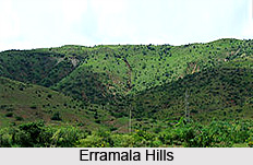
 Erramala are an exquisite range of low hills in Kurnool district of in the southern state of India, Andhra Pradesh. In the east of the Erramala hills is Nallamalla hills. The hills are situated on the Deccan Plateau and are composed of quartzites and slates of the Cambrian period with occasional beds of lavas of younger age.

The range spreads from northeast to southwest. The tributaries of the Kunderu River have divided it into hills and valleys. It is located between 15° 30` 0 North latitude and 78° 10` 0 East longitude.

(Last Updated on : 13/02/2009)
 
 
Veeramala Hills Annamalai Hills Brahmagiri Hills
Chamundi Hills Garo Hills Cardamom Hills
Horsley Hills Jaintia Hills Jampui Hills
Kalrayan Hills Khasi Hills Mizo hills
Naga Hills Nilgiri Hills Pachaimalai Hills
Palni Hills Seshachalam Hills Shevaroy Hills
Shivalik Hills Rajmahal Hill Malabar Hill
Durpin Hill Deolo Hill Kumara Hills
Chitrakuta Hill Erramala Hills Indian Himalayan Regions
Recently Updated Articles in Geography of India
Trisuli Peak
Trisuli is situated at an elevation of 7,074 metres above mean sea level in the Pithoragarh district of Uttarakhand.
Suj Tilla East Peak
Suj Tilla East situated in the Pithoragarh district of Uttarakhand is a part of the Kumaon Himalaya division.
Siniolchu Peak
Siniolchu is one of the tallest mountains in Sikkim situated at a height of 6888 meters (22,598 feet).
Nun Kun Peaks
Nun Kun peaks are the two neighboring peaks of the Himalayan range, lying close to Jammu and Kashmir.
Nanda Kot
Nanda Kot is a mountain peak in the Kumaon Himalayan range .
E-mail this Article | Post a Comment
Forum
Forum on Geography of India
Free E-magazine
Subscribe to Free E-Magazine on Reference
 
 
Erramala Hills, Kurnool, Andhra Pradesh - Informative & researched article on Erramala Hills, Kurnool, Andhra Pradesh
Sitemap
Contact Us   |   RSS Feeds
Copyright © 2008 Jupiter Infomedia Ltd. All rights reserved including the right to reproduce the contents in whole or in part in any form or medium without the express written permission of
Jupiter Infomedia Ltd.