Introduction
 Davanagere District is situated in the southern state of Karnataka and is an ancient city of historical importance. The district headquarter is located at Davangere. It was part of the kingdom of the Devagiri Yadavas.
History of Davanagere District
According to folklore, the name `Davangere` was derived from `Danivina Kere` which was a lake excavated to quench the thirst of the Chalukyas, who halted at this place to overcome the fatigue due to a long horse ride. `Danivina Kere`, in course of time became Devan giri, which evolved into `Davangere` or `Davanagere`. Davangere was a village located on the suburbs of Bettur. It was given away as a jagir by Hyder Ali of Mysore to Apoji Ram, his Maratha Chieftain. It became a major trading centre under Apoji Ram and also during the rule of Tipu Sultan. Davangere rose to the designation of a municipality in 1870. In the year 1997, Davangere became an individual district in Karnataka.
Geography of Davanagere District
Davanagere is well connected to the other parts of India by rail and road. It lies in the Maidan region on the Deccan plateau. It is surrounded by the Shimoga district, Haveri district, Chitradurga district and Bellary district. The prominent cities and towns of the district are Harihara , Honnali and Channagiri. Davanagere became a separate district in 1997 when it was separated from the district of Chitradurga.
Demography of Davanagere District
According to the Population Census in the year 2011, Davanagere District had population of 1,946,905 of which male and female were 989,602 and 957,303 respectively. The population of Davanagere District constituted 3.18 percent of total population of Karnataka. The population density of Davanagere district for 2011 is 329 people per sq. km. In 2001, Davanagere district density was at 302 people per sq. km. Davanagere district administers 5,926 square kilometers of areas.The average literacy rate of Davanagere in 2011 were 76.30 percent compared to 67.43 of 2001. If things are looked out at gender wise, male and female literacy were 83.02 and 69.39 respectively. The total literates in Davanagere District were 1,327,614 of which male and female were 732,582 and 595,032 respectively.
Administration Of Davanagere District
 Administration of Davanagere district is carried out mainly through Zilla Panchayat. Davanagere district is a newly formed district in Karnataka, which came into existence during 1997 by including backward taluks from other three districts viz. Chitradurga district, Shimoga district and Bellary district. It covers a total geographical area of 5975.97 Sq. Km.
The office of the Zilla Panchayat is the main body responsible for administration in the district. The office is headed by an officer designated as "Chief Executive Officer" who is appointed by the State Government. The CEO is responsible to carry out the administration of Zilla Panchayat. The rank of Chief Executive Officer is not below the rank of Deputy Commissioner of a district. Chief Executive Officer is designated head of department for all the department offices within the Zilla Panchayat. He is assisted in the discharge of his duties by Senior Officers in the Zilla Panchayat. These include the Deputy Secretary (Admin/Dev.), Chief Accounts Officer, Chief Planning Officer and Council Secretary.
The work of the Zilla Panchayat falls into five main categories. The administration section is headed by the Deputy Secretary and deals mainly with establishment issues and general administration of all the departments within Zilla Panchayat; the development section, also headed by the deputy secretary, deals with the execution of all rural development schemes, water supply schemes, minor irrigation works, road works etc; the accounts section is headed by the Chief Accounts Officer and deals with the receipts and releases of funds to all departments and various development schemes, taking up audit of all the departments coming under Zilla Panchayat; heading the planning section is the Chief Planning Officer, and the department is responsible for the formulation of draft annual plan, formulation of action plan for development schemes, monitoring and evaluation of schemes; the Council section is headed by the Assistant Secretary and is responsible for recording the deliberations of Zilla Panchayat and various standing committees, following up on various decisions taken therein and other issues regarding the Zilla Panchayat members.
The Political Structure of Zilla Panchayat comprises of President, Vice president and elected members. The term of Zilla Panchayat is 5 years.The roles of these members is to create and improvement of the infrastructural facilities such as roads, bridges, drinking water facilities, dispensaries, veterinary hospitals, schools etc. Regular meetings are conducted to identify problems faced in the district with specific focus on action to be taken to address and resolve the problems, development schemes necessary for implementation. The meeting resolutions are then passed on to the CEO of ZP who in turn plans and executes the development activities.
Davangere Zilla Panchayat is constituted of the following members:
There are 34 members are elected from geographically demarcated constituencies from within the rural areas of the district.
All the Members of Parliament of the district (1). The State Legislative Assembly (10) & the State Legislative Council (4). Also parts of administrative functions at the primary levels are the taluk panchayats and gram panchayats.
The Karnataka Panchayat Raj Act, 1993, specifies the constitution of the Taluk Pachayat, functions, duties and powers of the taluk panchayat adhyaksha upadhyaksha. The act lays down a three-tier structure of Panchayat. The apex institution, as has already been mentioned, lies at the apex of district administration. Of the six taluks in the Davanagere district, each has a taluk panchayat. Here too the members are directly from the people and has a similar administrative structure headed by the CEO. At the lowest level there are the Gram Panchayats which are having jurisdiction over a group of villages so notified. A number of functions are to be performed by the taluk panchayat such as construction and augmentation of water supply works to the level of not less than forty litres per capita per day, filing half yearly report regarding the activities of Grama Panchayats within the taluk, providing adequate number of class rooms and maintaining primary school buildings in proper condition including water supply and sanitation; acquiring land for locating the manure pits away from dwelling houses in the villages etc.
Each Taluk Panchayat consists of the following standing Committees: a. General Standing Committee; b. Finance, Audit and Planning Committee; c. Social Justice Committee. Thus mentioned is the administrative structure of the Davanagere district.
Temples of Davanagere District
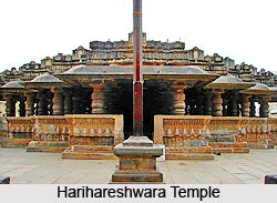 The temples of Davanagere district, stands unique and exquisite with its exceptional designs and architecture on the heart of the south Indian district of Karnataka. Davanagere district is an important commercial, industrial and educational center. However, this district has earned name as a tourist spot for its astounding temples. Some of the temples of Davanagere district include Durgambika Temple, Anagodu, Hadali, Harihar and Mayakonda.
Sri Durgambika temple is one of the most popular and the biggest temple in the district. It is located in old Davanagere or the Halepet in Shivajinagar. The land surrounding this auspicious temple is called "Devara Hatti". According to the legends, around 200 years ago a stone that was excavated from Duggatti village was worshipped as Godess Durgamma known by different names such as Dugamma, Durgavva, Durgambika and many others. During 1932, the small temple was converted into a beautiful temple with unique features. The temples of Davanagere district have unique shapes and forms that make them stand apart from the other temples of south India.
Tourism in Davanagere District
 Tourism in Davanagere district is a leisurely ride as there are a number of places located here where one can go to relax, sightsee and have a good time.
It is 6km from the district headquarters on Davanagere-Jaglur Road, about 2 km from Anekonda, Betur is a place of great historic significance. It was the capital of Tribhuvana Malla Pandya. When Betur was the capital, Davanagere was a part of Betur. It is believed that the king used to keep his cattle here. Ancient and artistic Kalleshwara temples sculpted in Chalukya style, artistic epigraphs and victory pillars record and depict history. In this district, there are several artistic sculptures found. There is a beautiful idol of Nataraja and Lord Shiva-Parvati atop Nandi in Muchagi as well as a monolithic sculpture of Saptamatrukas.
About 4 km from the headquarters on the Davanagere-Jaglur road, lies Anekonda - the place where elephants were tied up. According to legend, when Betur was the capital, the King`s elephants were tied here and hence the name. Aneknoda was a big city during 11th and 12th Century AD. The place has many epigraphs of Gandas, Uchangi, and rulers of the Pandya dynasty, Chalukya dynasty and the Hoysala Empire.
About 30 Kms from Davanagere is a very popular picnic spot, Sulekere. The pond is one of the largest in India. A large number of tourists visit this place regularly. There is also a temple called Sri Siddeshwara near the pond.
Kundwada Tank is situated on the left side of Pune-Bengaluru NH4 bypass road near Kundwada village of the Davanagere city. The catchments area of Kundwada tank is nearly 253 Acres. Recently, it was renovated and treated as Summer Water Storage Tank. Water supply facility provided by the tank covers more than 50% of the city area from past 2 years. Kundwada tank adds to the beauty of the city. Now, Davanagere City Municipal Council has made a resolution to rename Kundwada Tank as "Kundwada tank- renovated S. S. Mallikarjuna Sagara"
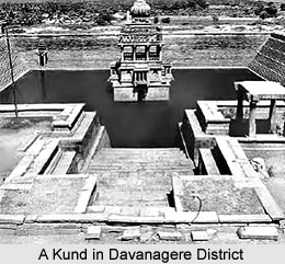
Santhebennur located at about 36 Kms form the district headquarters is famed as the most beautiful tank in South India. The wonderful sculpture resembling a stone chariot in the middle of the tank looks similar from all the four directions. The pushkarni is built in red stone in Kushmanda style in the 16th Century AD by Kenga Hanumanthappa Nayaka of Santhebennur. The "pushkarni" originally had eight mantapas of which only six exist now. The pushkarni has 52 big steps from its main entrance in the west. Other three sides have 44 steps each. Renowned for its architecture and sculpture, this great mantapa has four tires. Locals call this `Karnaji Mantapa` The water stored below the mantap had a system of springing out from the top.
About 8 km from Harpanahalli, Bagali has a 9th Century Kalleshwara temple of Chalukya period. There are Panchalinga temples on the premises of Kalleshwara temple and also beautifully sculpted Ugranarasimha idol. The Outer walls of the temple have erotic sculpting. Pillars inside the temple have intricate carvings. Thus, mentioned are the various places of tourist interest in Davanagere district.


