|
 The Daman Ganga River is a river of western India. The river has its source in the western slope of the Western Ghats range, and it flows towards the west and finally drains into the Arabian Sea. The Daman Ganga River is a river of western India. The river has its source in the western slope of the Western Ghats range, and it flows towards the west and finally drains into the Arabian Sea.
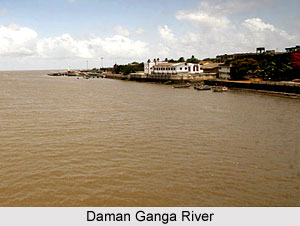
The river runs through the states of Maharashtra and Gujarat, as well as the Union territories of Daman and Diu and Dadra and Nagar Haveli. On the northern bank of the river lies the industrial towns of Vapi, Dadra and Silvassa. The town of Daman occupies both the banks of the river's estuary.
The National Water Development Authority (NWDA) run by the Government of India has proposed the Daman Ganga- Pinjal River Linking Project, which is expected to construct a new conduit linking the Daman Ganga river to the Pinjal River in the south. This would in turn divert the waters of the Daman Ganga Rivers towards the south to Mumbai through the Pinjal.
A recent research on the water quality of Daman Ganga River conducted by the Central Pollution Control Board (CPCB) brings to light that the river water is being continuously polluted by the sewage of nearby areas, especially Vapi. To check the river pollution, small-scale industries situated in the Vapi industrial region are taking necessary steps.
|
|
|
|
Articles you would like to read with Daman Ganga River
|
|
|
|
| • | Origin of Ganga River
The origin of Ganga River is Gangotri Glacier. Ganga is the holiest river in India.
| | | • | Bagmati River
Bagmati River is one of the snow fed rivers, which is dying for the accumulation of garbage by the people.
| | | • | Cooum River
Cooum River is the shortest classified river of South India. Due to urbanisation, this river becomes polluted.
| | | • | Kameng River
Kameng River, earlier known as Bhareli River, flows in Arunachal Pradesh and Assam. It is one of the chief tributaries of the Brahmaputra River.
| | |
|
|
|


