 Chhindwara district one of the important district of Madhya Pradesh is part of the Jabalpur Division. It occupies 4 percent of the state and ranks first in terms of area in Madhya Pradesh. Chhindwara town is the district headquarters. The name of the place is derived from "Chhind" (date palm) "Wada" (place) trees, as it is believed that this place was full of wild date palm trees and hence "Chhindwara".
History of Chhindwara District
History records the place from the time of the rule of Bhakth Bulund King, whose kingdom was spread over the Satpura Mountain range and it is believed that his rule was up to the 3rd Century. This dynasty ruled up to the 7th Century. Then the "Gondvana" dynasty had ruled the area with "Devgarh" as the capital. King "Jatav" of `Gond` community had built the Devgarh fort. Bhakth Bulund King was most powerful in the dynasty and he had adopted the Muslim religion during the rule of Emperor Aurangzeb. Later the power had changed many hands and finally `Maratha rule` ended in 1803. On 17th September 1803, British East India Company had taken over this kingdom by defeating `Raghuji II` and hence had started the British rule. After Independence `Nagpur` was made the capital of Chhindwara District, and on 1st November 1956 this district was re-constituted with Chhindwara as the capital.
Geography of Chhindwara District
Chhindwara District is located on the South-West region of `Satpura Range of Mountains`. It is spread from 21.28 to 22.49 Degree North (longitude) and 78.40 to 79.24 degrees East (latitude). It spread over an area of 11,815 Sq. Km. This district is bounded by the plains of Nagpur District (in Maharashtra State) on the South, Hoshangabad District and Narsinghpur District on the North, Betul District on the West and Seoni Districts on the East.
There are five major rivers, which flow through the district namely Kanhan River, Pench River, Jam River, Kulbehra River, Shakkar River, and Doodh River. Kanhan River flows in the Southern direction through the western parts of Chhindwara Tahsil and mixes with the Wainganga River. Jam river flows mostly through the Sausar region and joins with the Kanhan River. Pench River flows in the border areas of Chhindwara and Seoni Districts and mixes with the Kanhan River in Nagpur District. Kulbehra River starts at Umreth, flows through Chhindwara and Mohkhed, and joins with Pench River.
Demography of Chhindwara District
According to the Population Census in 2011, the Chhindwara District had population of 2,090,306. Out of which the male and female were 1,063,302 and 1,027,004 respectively. Chhindwara District population constituted 2.88 percent of total population of Madhya Pradesh. The population density of Chhindwara district is 177 people per sq. km. The average literacy rate of Chhindwara in 2011 was 72.21. If things are looked out at gender wise, male and female literacy were 80.76 and 63.38 respectively. The total literates in Chhindwara District were 1,316,324 of which male and female were 747,981 and 568,343 respectively.
Culture of Chhindwara District
Chhindwara District has majority of tribal population. The tribal communities include Gond tribe, Pardhan tribe, Bharia tribe, Korku tribe. Hindi language, Marathi language, Gondi language, Urdu language, Korku language, Musai language, Parvari language etc. languages are in use in the district. Majority of the tribals speak in Gondi and Hindi mixed with Marathi. Among the cultural festivals in the district are Pola, Bhujalia, Meghnath, Akhadi, Harijyoti etc. `Gotmat Mela` of Pandhurna is unique and world renowned fair. On Maha Shivratri day, `Mahadev Mela` will be celebrated each year on "Choudagadh".
Economy of Chhindwara District
Economy of Chhindwara District is based on large-scale industries. Some of the prominent industries are The Raymond Chhindwara plant, Spices Park, Bhansali Engineering Polymers, Suryawanshi Spinning Mills and many other heavy industries. This district also has a unit of Hindustan Unilever Limited, which is one of the most essential multinational companies in India. Spices Park in this district is India`s first spice park. It was opened in Chhindwara on 25th Feb 2009. This park includes an assemble part of seven parks. The Spices Board planned to build this park. The initial phase of the park consists of a Garlic Dehydration Plant set up by the Spices Board and a Steam Sterilization Unit set up by STCL Ltd., a public sector company. The park has come up in an area of 18 acres of land in Laas village, Umranala, on Chhindwara-Nagpur Highway.
Tourism of Chhindwara District
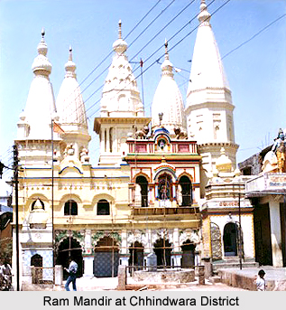
There are many prominent tourist spots in the district like Patalkot, Ram Mandir, Tamia, Tribal Museum, Chota Mahadev Cave, Devgarh Fort, Nadadwari, Hot Water Spring at Anhoni and Radhadevi Caves and Jam Sanvli Temple.


