


 Geographical Features of Dhanbad District
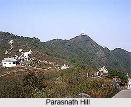
Dhangi hills are located in the western middle region between the grand chord line of the Eastern Railway and Grand trunk road in the north. These hills stretch from Pradhankhanta to Govindpur in the south and reaches to a height of 1,256 feet. In the north, a part of Parasnath hill runs through Topchanchi which is the highest point of 1500 feet. In the southern region, undulating soil stretches over the district. The most significant river of Chota Nagpur Plateau is Damodar River. It meets with Jamuria stream at the point where it enters the district. This stream borders the western boundary of Dhanbad district. Katri River joins Damodar River in the eastern part. Along the district, Damodar River flows for about 77 kilometres. Panchet dam stands over it and extends up to about 6 kilometres. Northern boundary of the district is formed by the River Barakar that travels through 77 kilometres. Barakar River flows in south west direction and reaches up to Durgapur and then flows to south to join Damodar River. Maithan Power Station is associated with it. Other small rivers of the district are Irji, Gobai and Khudia. Climatic Condition of Dhanbad District The district of Dhanbad has a dry climate. From the month of November to February, during winter season the weather is very pleasant. The climate becomes warm afterwards till the commencement of monsoon around the mid June. The temperature reduces and humidity rises with the beginning of rain. The wettest months in the district are July and August. Average annual precipitation in the district is about 1300mm. This article is a stub. You can enrich by adding more information to it. Send your Write Up to content@indianetzone.com |
| |||


Home > Travel > States of India > Jharkhand > Districts of Jharkhand > Dhanbad > Geography of Dhanbad District
Geography of Dhanbad District
| Dhnabad district is geographically divided into three zones and hosts a number of rivers and streams. |
| ||||||||||||||||||||||||||||

