 Mainpuri District is an administrative district of Agra Division in Uttar Pradesh. Mainpuri town is the district headquarters. Mainpuri District is bounded on the north by Etah District, on the east by Farrukhabad District and Kannauj District, on the south by Etawah District and on the west by Firozabad District and Etah District. It lies between 26 degree 53 minutes to 27 degree 31 minutes north latitude and 78 degree 27 minutes to 79 degree 26 minutes east longitude. Total area of Mainpuri District is 2760 sq kms. According to 2001 Census, total population of the district is 1596718, of which male population is 859934 and female population is 736784. Literacy rate of the district is 65.09 percent. The common dialect of the people in Mainpuri District is Braj Bhasha which is the oldest form of Hindi language.
History of Mainpuri District
History of Mainpuri District includes a series of events. However, ancient history of the region is vague as it is not supported by any concrete evidence. Mainpuri District was ruled by several rulers and dynasties. Before the arrival of British, this region was under the control of Muslim rulers. Mainpuri formed a part of kingdom of Kannauj. Mainpuri was conquered by Babur in 1526, but subsequently it fell in the hands of the Marathas. This district was finally surrendered to the British.
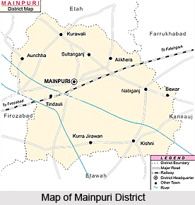
Geography of Mainpuri District
Kali River and Yamuna River are the two main rivers flowing through the district. Taking the district from north to south, the average fall of the rivers, excluding the Yamuna, in 1.5 feet per mile, and the average slope of the surface of the country is 1.2 feet per mile. A line of levels taken across the district from the Yamuna to Kali shows that the watershed of the streams running through it at the point of intersection are almost exactly the same height above the level of the sea. The barren land of the district consists for the most part of user plains, which extend for miles in certain portions of the loam tract, chiefly in Parganas Mainpuri, Ghiror, Bhonagaon, Karhal, Kishni, the north of Barnahal and Mustafabad. A considerable area of the barren land is covered with forests, and this district is abundantly rich with groves of fruit and timber trees. Mainpuri District has several swamps and marshes, particularly in its central portion but few of them are of sufficient size to deserve the name of lake.
Economy of Mainpuri District
Economy of Mainpuri District is entirely dependent on agriculture. Agricultural year is divided into the three main seasons of harvests - kharif, rabi and zaid. Main kharif cereals in the district in order of the area they cover are maize, bajra, pulses and rice. Barley, gram, pea and mustard are main rabi crops cultivated in the district. Mainpuri District has ample means of irrigation like canals, wells, including tube-wells, and rivers. The rivers are not of much direct use for irrigation, well and tube-wells constitute a major and more reliable source of irrigation.
Lack of enterprise and technical training and insight among the people has been the major constraint in the industrial growth of Mainpuri District.


