Geography of Saharanpur District
|
Geography of Saharanpur District includes Ganga and Yamuna as the main rivers flowing through district. Saharanpur District can be distinctly divided into four regions and enjoys a typical tropical climate.
|
|
|
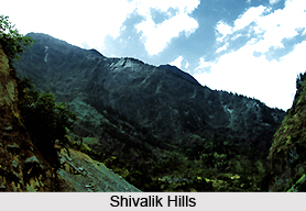 Geography of Saharanpur District presents many varieties of features and differs in general appearance than any other portion of the Doab and Gangetic plain as a whole. Saharanpur District forms the most northerly position of the Doab land which stretches between Ganga River and Yamuna River. Shivalik Hills rise above it on the northern frontier. The portion of Doab in which Saharanpur is situated was probably one of the first regions of upper India occupied by the Aryans colonizers as they spread eastward from Punjab. It is true that most of the area belongs to the upland Bangar which stretches in a continuous line up to Allahabad. Geography of Saharanpur District also includes low lying valley full of swamps and back waters with wide open grass plains and Tamarisk jungle. But in the north there are the steep hills of Shivalik chain which appear in a far more marked form in Saharanpur than any other district of Uttar Pradesh. Geography of Saharanpur District presents many varieties of features and differs in general appearance than any other portion of the Doab and Gangetic plain as a whole. Saharanpur District forms the most northerly position of the Doab land which stretches between Ganga River and Yamuna River. Shivalik Hills rise above it on the northern frontier. The portion of Doab in which Saharanpur is situated was probably one of the first regions of upper India occupied by the Aryans colonizers as they spread eastward from Punjab. It is true that most of the area belongs to the upland Bangar which stretches in a continuous line up to Allahabad. Geography of Saharanpur District also includes low lying valley full of swamps and back waters with wide open grass plains and Tamarisk jungle. But in the north there are the steep hills of Shivalik chain which appear in a far more marked form in Saharanpur than any other district of Uttar Pradesh.
Yamuna is the important river of the district. Apart from this Solani, Hindon, Ratmau, Nagdev have also played an important role in the physical reconstruction of the district. All the rivers of the district submerge either in Yamuna or in the Ganges. Saharanpur District has a tropical climate because of the proximity of the Himalayan region across this district. It is sub-humid region especially the upper Ganga plain areas. Saharanpur District records an average temperature around 23.3 degree during the course of the year. June is the hottest recorded month while January is the coldest one. Humidity is more in the western area as compared to the eastern region of Saharanpur.
As regards its physical features the north and the north east portion of Saharanpur District is surrounded by Shivalik hills and separates it from Dehradun District of Uttaranchal. River Yamuna forms its boundary in the west which separates it from Karnal and Yamunanagar districts of Haryana. In the east lies Haridwar District which was the part of district Saharanpur before 1989 and in the south is district Muzaffarnagar. The main characteristics of geography of Saharanpur District can be divided into four parts - Shivalik Hill Tract, Bhabar Land, Bangar Land and Khadar Land.
The region is very poor in mineral resources. Limestone stone boulders are the only main minerals. Limestone is found in the Shivalik hills. The physical features and the climatic conditions of Saharanpur District have played an important role in shaping its history and making it an important part from the rest of the country.
|
|
|
|


