


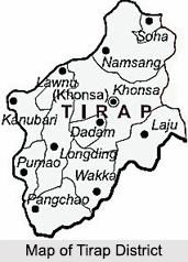
 Located in the south –eastern part of the state of Arunachal Pradesh, the Tirap district shares an international state border with Nagaland and Assam. The Tirap district derives its name from the river Tirap which originates in this district and flows through Changlang district. The entire area of this district is covered with high hills and deep valleys. Khonsa is the district headquarters. Located in the south –eastern part of the state of Arunachal Pradesh, the Tirap district shares an international state border with Nagaland and Assam. The Tirap district derives its name from the river Tirap which originates in this district and flows through Changlang district. The entire area of this district is covered with high hills and deep valleys. Khonsa is the district headquarters.
History of Tirap District The history of the Tirap District has emerged from obscurity and dubious traditions in the early part of the 13th century A.D. This was the time when the Ahom tribe came along and made steady advance along the course of the Noa-Dihing River in Tirap. The strategic position of the Tirap district placed between the plains of the Brahmaputra on the west and the valley of the Irrawaddy on the east created a gateway in the ancient times by granting an easy access to India from the east. This area witnessed movement of the people from the Patkai ranges from time immemorial. In the ancient Indian scriptures, hordes of migratory tribes of Mongoloids called kirata drifted to Assam through this district. It was in Assam and its neighbouring regions that these tribes were absorbed. During the 16th century, tribes such as the Nocte came to settle in the area, at the time of reign of the Ahoms. In 1945, the Japanese troops attacked and took control of the district but after their collapse the Tirap district has been the main target of a Naga rebel group that particularly aims to transform the local tribal people into Christianity. Geography of Tirap District The geography of the Tirap District comprises mostly of hilly and mountainous regions including several deep valleys. This district is bounded by Myanmar in the south, Changlang district in the east, the Dibrugarh district of Assam in the north and the Sibsagar of Assam and Mon of Nagaland in the west. The Tirap district covers a total area of 2,362 sq. km and is known to have the highest density of population of 42 persons per sq. km. 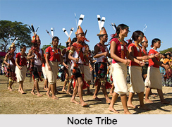 Demographics of Tirap District Demographics of Tirap District
The major portion of the people residing in the district is the indigenous tribal groups which constitute more than 70 per cent of the total population of Tirap district. The major tribes inhabiting in the district are the Nocte tribe, Wancho tribe and the Tutsa tribes. Out of the total tribal population of the Tirap district, in the tribal groups, the Noctes form about 45% the Tutsas about 5% and the Wanchos almost 50% . The demography of the Tirap district also suggests that each of these three tribes inhabits a separate geographical area and has its own social norms, traditions, customs, beliefs and practices. As per the reports of Census India 2011, the total population of the Tirap district is 1, 11,997 out of which the male population is 52,537 and female population is 47,789. The average literacy rate of the district is about 53% out of which the male literacy rate is lower than the female at a percentage of 29% and 42% respectively. Flora and Fauna of Tirap District The flora and fauna of Tirap district is rich and diverse, the plants of the Tirap district mostly comprise of tropical as well as sub-tropical evergreen forests with combined grasslands and moderate forests in the high hills. Varieties of birds can be found in the evergreen jungle on the plains and the lower slopes like the Spot-billed Duck, the Comb Duck, the Lesser Whistling Duck, the large Whistling Teal and Cotton Teal. The other birds that are frequently found are the Black-naped Green Woodpecker, Rufous-necked Hornbill, Maroon Oriole, Minivets and other high altitudinal birds like the common hill partridges, Blyth’s Tragopan etc. Places of Attraction in Tirap District The places of interest in the Tirap district are quite few and listed below are some of the places of attraction in this region. Khonsa: It is the headquarters of the Tirap district and is a small hill station in a valley surrounded by the Himalayas. Created during the British period, it is one of the 5 earliest districts of the state. Surrounded by panoramic views of thick forests fringed by hills, Khonsa is a paradise to the visitor’s eye. The forests around Khonsa host wild beings from tigers, leopards, white gibbon monkeys, jackals, wild boars, bears, barking deer, red panda, musk deer, mithun and numerous species of rodents. A spectacular attribute of this place lies in the ethnicity of the tribes and their festivals, fairs and flawless artworks which are created with intense dedication. Khonsa Museum: Built in the year 1956, the Khonsa museum houses some of the amazing artefacts which represent the diverse culture of the district. Swords and other weapons are on display here. Apart from that, the museum houses handlooms and artefacts collections that represent the culture of various parts of India. Different types of cane and bamboo works can also be seen here. 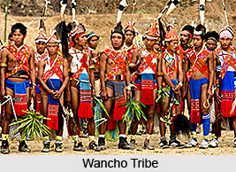 Festivals in Tirap district Festivals in Tirap district
The festivals of the Tirap district include the main festivals of the different indigenous tribal groups of the region and reflect the distinct cultural and ethnic identity of the people. Listed below are some of the festivals held in this region: The Loku Festival: It is a major festival of the Nocte tribe. The term Loku literally means to drive out the old season of the year. The Loku Festivalis celebrated during the month of July or August. The date of the festival is fixed by the elders of the community. The Pongtu Kuh Festival: Celebrated by the Tutsa tribal community, along with the Pongtu Kuh Festivalthey also have another festival called the Ronghun Kun. These celebrations are considered as an integral part of the socio cultural life of the Tutsa tribe. They are celebrated usually in April every year for obtaining the blessings for proper Jhoom cultivation. The Ojiyele Festival: The Ojiyele festival is the major festival of the Wancho tribe and is also known as Oriya festival. It replicates the rich customs and heritages of the local inhabitants of Tirap district and it is usually held in the months of March to April interspersed with prayer, song and dance. Villagers exchange bamboo tubes of rice beer as a mark of greeting and good will. Visiting Information on Tirap District There is no direct train service to Tirap. The nearest railway stations are at Dibrugarh, Tinsukia or Naharkatia in Assam. The closest airport is Dibrugarh at a distance of approximately 119 km and is well connected to Guwahati. |
| |||


Home > Travel > States of India > Arunachal Pradesh > Districts of Arunachal Pradesh > Tirap District
Tirap District
| Considered to be the 5th most populous district in the state of Arunachal Pradesh, the Tirap District is mountainous and is fully covered with deep gorges. |
| ||||||||||||||||||||||||||||

