


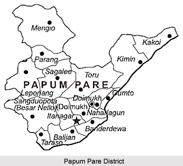
 Papum Pare district is the administrative district of Arunachal Pradesh. The district headquarters are at Yupia. Itanagar, the capital city of the state of Arunachal Pradesh is also located at this district. The people belonging to Nishing tribe of Arunachal Pradesh mainly inhabit this district. The Papum Pare district is described as the land of lush green forests, deep river valleys and stunning plateau. The area is predominantly mountainous with Himalaya Mountain ranges. The Deputy Commissioner heads the district administration of Papum Pare District. The Papum Pare district is divided into two major administrative sub-divisions, which are Segalee Sub-Division and Itanagar Capital Complex Sub-division. Further, there are ten administrative circles- Segalee, Mengio, Toru, Leporiang, Kimin, Balijan, Doimukh, Tarasso, Itanagar and Naharlagun. Papum Pare district is the administrative district of Arunachal Pradesh. The district headquarters are at Yupia. Itanagar, the capital city of the state of Arunachal Pradesh is also located at this district. The people belonging to Nishing tribe of Arunachal Pradesh mainly inhabit this district. The Papum Pare district is described as the land of lush green forests, deep river valleys and stunning plateau. The area is predominantly mountainous with Himalaya Mountain ranges. The Deputy Commissioner heads the district administration of Papum Pare District. The Papum Pare district is divided into two major administrative sub-divisions, which are Segalee Sub-Division and Itanagar Capital Complex Sub-division. Further, there are ten administrative circles- Segalee, Mengio, Toru, Leporiang, Kimin, Balijan, Doimukh, Tarasso, Itanagar and Naharlagun.
History of Papum Pare District Initially, the Papum Pare district was a portion of the organizational unit of Western Section of North-East Frontier Tract. It was renamed as Balipara Frontier Tract in 1919. This tract was bifurcated into two organizational units in 1954, and these units are the Subansiri Frontier Division and the Kameng Frontier Division. The Subansiri Frontier Division became Subansiri District in the year 1965. Further, in the year 1987 Subansiri District was divided into Upper Subansiri District and Lower Subansiri District. The Papum Pare District was created from the Lower Subansiri District in 1993. Geography of Papum Pare District 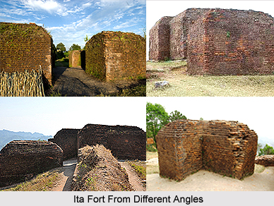 The Papum Pare district is situated in between latitude 26 degrees 55 minutes North and 28 degrees 40 minutes and longitude between 92 degrees 40 minutes and 94 degrees 21 minutes. The topography of this district basically comprises endless high hilly regions. The entire region forms a part of the Eastern Himalayas. The Papum Pare district comprises a foothill region bordering the state of Assam and the towering mountain that is extending in the northward direction. In the north, Papum Pare district is bounded by Kurung Kumey District, in the east by Lower Subansiri District, in the west by East Kameng District and in the south by Assam.
Demography of Papum Pare District The Nishis or Nishing tribe are the local inhabitants of Papum Pare district. Moreover, Mikir Tribe, who are the migrants from the neighbouring state of Assam, form a major part of the local population. The Nishis belong to the Indo-Mongoloid group of people and their language belongs to the Tibeto-Burman language family. Nishi tribe are also known as the followers of the Baptist sect of Christianity. According to the Population Census in the year 2011, the Papum Pare district has a population of 176,385. This gives the ranking of this district as the 594th Village in India, out of 640 villages in India. The Papum Pare district has a population density of 51 inhabitants per square kilometers. Its population growth rate over the decade 2001-2011 was 44.57%. Papum Pare has a sex ratio of 950 females for every 1000 males. The literacy rate of the Papum Pare is 82.14%. Tourism of Papum Pare District Papum Pare district is popular for its vast range of tourist places and sightseeing options. The popular places of interest include Itanagar, Doimukh, Segalee, Kimin. Some of the main places of interest of Itanagar are Ita fort (13th century ruins of a brick fort), Ganga Lake (Gekar Sinyi), Zoological Park (Chimpu), Jawaharlal Nehru State Museum and Buddhist Gompa and Theravada Buddhist Temple Arunachal University, Rono Hills. Papum Pare district attracts people from different parts of the world through its rich and indigenous customs and traditions besides its magnificent tourist attractions. |
| |||


Home > Travel > States of India > Arunachal Pradesh > Districts of Arunachal Pradesh > Papum Pare District
Papum Pare District
| Papum Pare district is one of the beautiful districts of the state of Arunachal Pradesh. This administrative district is the abode of the Nishing tribe of the state. Yupia is headquarters of Papum Pare district. |
| ||||||||||||||||||||||||||||

