Introduction
 Murishidabad district is one of the 18 districts of the state of West Bengal. It has a rich historical and cultural background, and served as the last capital city of independent Bengal. Murshidabad was named after Nawab Murshid Quli Jafar Khan, the Diwan of Bengal, Bihar and Orissa and declared the capital of Bengal in 1717. It is best known for Plassey, the site of the historic battle between Nawab Siraj-Ud-Daula and Robert Clive of the East India Company which led to a British stronghold in India. The district is well known for the Silk sarees produced here, which at one time had formed one of the important exports of the English East India Company to England. The district boasts of a number of mango delicacies such as Shadulla (Himsagar), Ranipasand (favourite to the queen), Begumpasand (favourite to the Begum), Sharanga, Mulayamjam and Kohitur (the king of mangoes).
History of Murshidabad
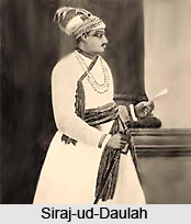 The ancient history of Murshidabad can be recorded from the period when Sasanka, the king of Gouda, established Murshidabad as his capital city. Following Sasanka, his Pala descendants also established their capital city in Murshidabad. During the Pala age, Murshidabad earned an unblemished glory in its unique culture. But the present history of Murshidabad, however documented from the time when Nawab Murshid Kuli Khan shifted his capital from Dacca to Murshidabad. Siraj-ud-daulah was the last sovereign ruler of Bengal who even had his capital in Murshidabad. Finally, when the British occupied Bengal, in the history of Murshidabad a new era started.
The history of Murshidabad so far is known is deciphered from the archaeological excavation and the relics of the earliest buildings scattered in the district. The Mauryan influence was introduced with the conquest and the establishment of the Radha region and incorporated it with the territory of Murshidabad by Bimbisara. However there is a mention of the Radha region in the Jain scripture Acharanga Sutra in the 6th century B.C, which reveals that the history of Murshidabad traces back even in the 6th century B.C.
The Mauryan history of Murshidabad though inaugurated by the Mauryan Emperor Bimbisara, the Nandas overthrew the Mauryas and established their supremacy in the entire area of Murshidabad. Finally the vibrant Maurya king Chandragupta Maurya washed away the Nandas and reinstated the Maurya supremacy in Murshidabad. As the ancient history of Murshidabad points out, the Maurya kings ruled Murshidabad for ages and the Ashokan stupas in Kanvasuvarna (falls under present Murshidabad) indicates Murshidabad to be a part of the Maurya Empire for long. The accounts of the Chinese traveler Hiuen Tsang are also an important source regarding the history of Murshidabad.
The post- Mauryan history of Murshidabad was composed by a long session of the Shungas and the Kushanas. The reign of the Shungas cannot be ascertained because there is no extant evidence of their reign in Murshidabad. The Kushana coins, which have been excavated in the Rajbari Danga region of Murshidabad, indicate the existence of the Kushana kings in Murshidabad. The coins indicate that the Kushana kings conducted the business transactions throughout the Middle East and the southeast countries with Murshidabad as the core center.
 The Gupta kings ousted the Kushanas from Murshidabad and they retained their supremacy for longest period, till the 6th century A.D., as the history of Murshidabad reveals. The accounts of the Chinese traveler, I-Tsing, arrived during the Gupta era depict the cultural prosperity that Murshidabad attains under the patronization of the Gupta kings. The Gupta period constituted the glorious chapter in the history of Murshidabad.
However the sovereignty of the Guptas at the end of the 6th century A.D became nominal. The earliest history of Murshidabad however codified in a written document only from the reign of Sasanka. Moreover the inscription of the kings of the time also mirrors the contemporary history of Murshidabad. However Sasanka did not rose in power suddenly. Before the advent of Sasanka, king Ishanavarmana invaded the entire area of Murshidabad and shattered the Guptas. Finally when the Guptas tried to conquer their former kingdom, Mahasenagupta however managed to snatch it away from them and installed his own realm over the extensive areas of Murshidabad. Sasanka was perhaps a vassal chief under him. When the Maukharis were engaged in warfare, Sasanka exploited the disturbed situation to its best and became the king of Gouda, with Kanvasuvarna as his capital. After becoming the king Sasanka extended his kingdom even to the distant west, for which the boundary of Murshidabad also underwent certain changes.
Sasanka, the violent conqueror, engaged in aggressive warfare to extend the kingdom of Bengal and finally since his time for about 100 years, Bengal witnessed a period of long anarchy and internal discord. Finally in the 760 A.D, Gopala introduced was elected the king, who introduced the Pala dynasty in Bengal. About 400 years of the history of Murshidabad was constituted by the Pala regime in Bengal. The remnants of the Pala king Mahipala in the Janigarh sub division indicate that the king has capital in the Janigarh subdivision of Murshidabad, which at that time probably known as Mahipal Nagar. But, when the Sena dynasty rooted themselves in the extensive land of Bengal, the major parts of Murshidabad came under the sway of the Senas and they continued to be the last sovereign Hindu ruler before the Muslim Rule stared in Bengal.
The beginning of Muslim era, as the chronicles of Murshidabad depicts that it was pronounced with the conquest of Bakhtiyar Khalji. The Muhgal chief ousted the last Sena king Lakshman Sena and the old king fled to East Bengal. This event initiated the Turko-Afgan rule in Bengal. The Muslim reign in the history of Murshidabad was an episode marked with ruthless suppression of the native and plunder of their property by the Muhgal personnel.
Fakir-ud-din Mubarak carried out the Turko- Afgan epoch originated by Bakhtiyar Khalji with prosperity. The sultanate period in the history of Murshidabad began in the year of 1338. A Hindu chief, Ganesha again rose in power and overthrew sultan Giyas-ud-din- Ajan Shah in 1417, however it was for a brief spell Bengal was under this Hindu chief.
 Sher Shah established Afgan era in Bengal by occupying Mahmud Shah in Bengal in 1538 and consecrated the throne. During the reign of Sher Shah, Murshidabad was an important center in Bengal. As far the history of Murshidabad dates back, the city was an important trade center during his reign.
Murshidabad was under the different Afghan rulers, until, the last Afghan ruler Dayud Khan was defeated by the Mughals. However it takes a long period of 20 years, to establish the Muhgal supremacy in Bengal. As the ancient history of Murshidabad depicts, during the beginning of 17th century, when the alien communities like the British, French, Dutch and the Americans established Murshidabad as the key site of carrying out business transaction, a group of business community including local Hindu traders, Immigrants from North India and even the Muslim chiefs etc grew up. When the socio-political panorama was vitiated by the discord between the Muhgals and the local natives, the Dutch and the French exploited the situation, to strengthen their military fortifications. The history of Murshidabad records the Dutch and the French establishment in Murshidabad, sowed the seeds of alien colonization in India.
After the Mughals the Nawabs continued to be the ruler of Murshidabad. Murshid Kuli Khan, who shifted his capital ("Dewankhana") from Dhaka to Maksudabad and named it as Murshidabad was the first Nawab of Bengal. His heirs were the superior Nawabs of Bengal and as the history of Murshidabad points out, that Siraj-ud-daula`s reign was the significant episode in the history of Bengal. During his reign, the British established their trade in Bengal and finally defeating him in the battle of Plassey established the political hold of Bengal. Murshidabad, being the capital of Siraj, shared an important role during this period. Finally the British swayed down the Nawab establishment and do away with Siraj. The British reinstate Mir Jafar to the "masnad" of Bengal, just to make hoim a puppet in their hands. The age of the Nawabs was concluded with the full-fledged British rule in India, as well as Bengal.
In 1765, when Shah Alam II attributed the British with the grant of Diwani, The Nawab existed as simple pensioner in the area of the British. The British charge a considerable amount of revenue and the indescribable collection of revenue led to a great famine. Finally the capital was shifted from Calcutta to Murshidabad. On 24th February 1857, when the entire country was aflame with the fire of the sepoy revolt, the Sepoys of 19th regiment of Native infantry of Berhampore regiment revolted. The revolt triggered the first of Independence called Sepoy Mutiny.
 Murshidabad from its very advent has survived to be the capital city of the kings who have inhabited the land for ages. Finally it was during the British imperialism capital has been shifted from Murshidabad to Kolkata. Both the ancient & past history of Murshidabad formed a significant part of the history of India. Sasanka, the violent conqueror, engaged in aggressive warfare to extend the kingdom of Bengal and finally since his time for about 100 years, Bengal witnessed a period of long anarchy and internal discord. Finally in the 760 A.D, Gopala introduced was elected the king, who introduced the Pala dynasty in Bengal. About 400 years of the history of Murshidabad was constituted by the Pala regime in Bengal. The remnants of the Pala king Mahipala in the Janigarh sub division indicate that the king has capital in the Janigarh subdivision of Murshidabad, which at that time probably known as Mahipal Nagar. But, when the Sena dynasty rooted themselves in the extensive land of Bengal, the major parts of Murshidabad came under the sway of the Senas and they continued to be the last sovereign Hindu ruler before the Muslim Rule stared in Bengal.
The beginning of Muslim era, as the chronicles of Murshidabad depicts was pronounced with the conquest of Bakhtiyar Khalji. The Muhgal chief ousted the last Sena king Lakshman Sena and the old king fled to East Bengal. This event initiated the Turko-Afgan rule in Bengal. The Muslim reign in the history of Murshidabad was an episode marked with ruthless suppression of the native and plunder of their property by the Muhgal personnel.
Fakir-ud-din Mubarak carried out the Turko- Afgan epoch originated by Bakhtiyar Khalji with prosperity. The sultanate period in the history of Murshidabad began in the year of 1338. A Hindu chief, Ganesha again rose in power and overthrew sultan Giyas-ud-din- Ajan Shah in 1417, however it was for a brief spell Bengal was under this Hindu chief.
Sher Shah established Afgan era in Bengal by occupying Mahmud Shah in Bengal in 1538 and consecrated the throne. During the reign of Sher Shah, Murshidabad was an important center in Bengal. As far the history of Murshidabad dates back, the city was an important trade center during his reign.
Murshidabad was under the different Afghan rulers, until, the last Afghan ruler Dayud Khan was defeated by the Mughals. However it takes a long period of 20 years, to establish the Muhgal supremacy in Bengal. As the ancient history of Murshidabad depicts, during the beginning of 17th century, when the alien communities like the British, French, Dutch and the Americans established Murshidabad as the key site of carrying out business transaction, a group of business community including local Hindu traders, Immigrants from North India and even the Muslim chiefs etc grew up. When the socio-political panorama was vitiated by the discord between the Muhgals and the local natives, the Dutch and the French exploited the situation, to strengthen their military fortifications. The history of Murshidabad records the Dutch and the French establishment in Murshidabad, sowed the seeds of alien colonization in India.
 After the Mughals the Nawabs continued to be the ruler of Murshidabad. Murshid Kuli Khan, who shifted his capital ("Dewankhana") from Dhaka to Maksudabad and named it as Murshidabad was the first Nawab of Bengal. His heirs were the superior Nawabs of Bengal and as the history of Murshidabad points out, that Siraj-ud-daula`s reign was the significant episode in the history of Bengal. During his reign, the British established their trade in Bengal and finally defeating him in the battle of Plassey established the political hold of Bengal. Murshidabad, being the capital of Siraj, shared an important role during this period. Finally the British swayed down the Nawab establishment and do away with Siraj. The British reinstate Mir Jafar to the "masnad" of Bengal, just to make hoim a puppet in their hands. The age of the Nawabs was concluded with the full-fledged British rule in India, as well as Bengal.
In 1765, when Shah Alam II attributed the British with the grant of Diwani, The Nawab existed as simple pensioner in the area of the British. The British charge a considerable amount of revenue and the indescribable collection of revenue led to a great famine. Finally the capital was shifted from Calcutta to Murshidabad. On 24th February 1857, when the entire country was aflame with the fire of the sepoy revolt, the Sepoys of 19th regiment of Native infantry of Berhampore regiment revolted. The revolt triggered the first of Independence called Sepoy Mutiny.
Murshidabad from its very advent has survived to be the capital city of the kings who have inhabited the land for ages. Finally it was during the British imperialism capital has been shifted from Murshidabad to Kolkata. Both the ancient & past history of Murshidabad formed a significant part of the history of India.
Geography of Murshidabad District
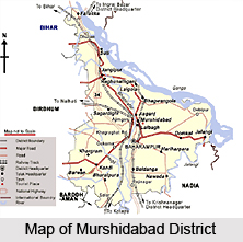
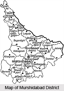 Murshidabad district is one of the central districts located in the state of West Bengal. It lies to the South of the Ganga River between 23 degrees 43 minutes and 24 degrees 52 minutes north latitude, and 24 degrees 52 minutes and 87 degrees 49 minutes and 88 degrees 44 minutes east longitude. In shape, the district resembles an isosceles triangle with its apex pointing to the North-West. The Padma River flows through the entire eastern boundary, separating the district from the Malda District and Rajshahi (Bangladesh). Burdwan District and Nadia District are on the Southern side and Birbhum District and the Pakur district (Jharkhand)are on the western side of Murshidabad district.
The Bhagirathi River has bifurcated the triangle-shaped district and divided it into two broad geographical regions of almost equal area and having a striking difference in their geology, in the agricultural and habitation pattern and even in the religions of their inhabitants.
These are:
Rarha Area - This is the area to the west of the Bhagirathi River having the pre-dominant geographical character of a plateau. It is substantially a continuation of the Sub-Vindhyan region of laterite clay. The land is high, slightly undulating, but is interspersed with numerous swamps and beds of old rivers. The soil is greyish and reddish, rich in lime and iron oxide. The rivers in this part originate from hill torrents and they are prone to overflowing due to sudden rain.
Hijal: It is a tract within Rarha, situated in the south-west of the district near the confluence of the Mor and Dwarka River, covering about 50 sq. miles in area. Here the country becomes more open, and, in place of Rice fields large stretches of thatching grass cover an almost treeless plain. During the rains, this area is widely inundated with water. Again, it becomes dry in the winter and a large portion of it is cultivated with Rabi crops.
Bagri Area - This is the area to the east of the Bhagirathi formed by Gangetic alluvial deposit. This area was formed later than the Rarha Area. It lies entirely between the Ganga, the Bhagirathi and the Jalangi River. The area is low, and therefore, exposed to annual inundations resulting in fresh silt deposits, and hence it is very fertile. A great variety of crops are grown here.
The Kalantar bil is a continuation of Bagri in the south-eastern corner of the district and receives the drainage of the swampy rivers in the eastern part of the district. It is a very swampy tract of dark clay and it is good as a rice growing area.
The tract of Bagri, lying east of Bhagirathi is covered with recent alluvium, consisting of sandy clay and sand along the course of the rivers, and fine silt consolidating into clay in the flatter parts of the plain; sometimes the areas form saucer-like depressions. A bank of stiff clay, gravels and calcareous nodules called ghuting forms the junction of the alluvium and higher grounds on the west of Bhagirathi. In the north-west of the district are some isolated clay hillocks.
The general inclination of the district west of the Bhagirathi is from north - west to south - east; but in the tract east of Bhagirathi, the lines of drainage is somewhat irregular as the main rivers do not uniformly take this direction.
Though the western half of the district slopes eastwards toward the Bhagirathi, a number of the hill streams do not find their way directly into that river; they are intercepted by bils or marshes and for the most part are carried off to the south by the Dwarka. The two chief drainage basins in this part of the district are that of the Bansloi in the north and that of the dwarka with its confluents, in the south. The large bils act as reservoirs during the flood by absorbing some of the excess water carried down by these streams, and also drain the excess water through the streams, emanating out of them.
The eastern half of the district may be described as an isosceles triangle. The Ganga (Padma) and the Bhagirathi forms the two equal sides; The Jalangi forms almost the entire base. However, the line of drainage is not along any of these rivers. The local rainfalls in this part of the district do not run off either into the Ganga or the Bhagirathi. The floods of these two great rivers converge towards each other, and ultimately make their way in a south - eastern direction. It may be roughly stated that the greater part of the surplus water ultimately falls into the Jalangi by means of the Gobranalah, the Bhairab and the Sialmari. During rainy seasons these canals, are connected with a number of bils, forming a network of water communication.
There is hardly any forest covering in the district. Most of it has trees common to the deltaic regions of the State. In the west and the north regions of the district, one gets to see plants similar to the plateau regions of the state. The common crops are also similar to that of the deltaic Bengal. There are fruit bearing trees of various types; but what the district boasts of is its varieties of mango delicacies. Many varieties available are unique to the district and trace their origin to the days of the Nawabs. Shadulla (Himsagar), Ranipasand (favourite to the queen), Begumpasand (favourite to the Begum), Sharanga, Mulayamjam, Kohitur (the king of mangoes) are among the varieties cherished by the connoisseurs. The common animals found in the district are jackals and black-faced monkeys. Though there is not much forest coverage, there are many water bodies like rivers, canals, lakes and ponds and an abundance of trees and shrubs in the district. Therefore, here one finds birds of many species including some migratory birds. The water bodies attract many water birds like the dabchick / little grebe, cormorants of different types, Indian shag, darter, ibis, herons, egrets, storks, teals and ducks of many kinds. Besides, one gets to see kites, pheasants, fowl, woodpeckers, cuckoos etc.
People in Murshidabad District
Like other parts of Bengal, there has been an inter-racial mixing in Murshidabad as well. The original inhabitants of the district are found among the Hindu and the Muslim communities. There have been immigrations in the ancient period from Northern India (Karnary and Rajputana) and Southern India (Karnat). During the Nawabi regime the Jains from Rajasthan came and settled here. Now they mostly live in the Jiaganj - Azimganj area. During the early Turkish invasions, Turk, Arab and Persian immigrants also settled here, but their numbers are few. Europeans from countries like England, France, Netherlands etc. settled here temporarily during the eighteenth century. But there are hardly any Europeans in the district now. There is a sizable number of Santhals in the Nabagram Block of Lalbagh Sub-Division.
 But they have also migrated about a hundred years ago from the neighbouring Birbhum District and other parts of the Chota Nagpur Plateau. Among other native communities Mal and Rajbansi, communities need special mention. The Chais are peculiar to this district and neighbouring Malda.
Economy of Murshidabad
 The economy of Murshidabad is fundamentally agrarian. The lack of economically important minerals and proper infrastructure is a hindrance to the growth of industries in Murshidabad. Hence agriculture, supplemented by the cottage industries shaped the economic scenario of Murshidabad.
The triangular tract of Murshidabad presents regional homogeneity and is provided by ample water of the Ganges and its tributaries, which favorably helped the agriculture to thrive, thereby supporting the economy greatly. The yield per hectares of land in respect of rice, wheat and fibers are respectively 1124 kgs, 2007 kgs and 1540 bales. Apart from this, horticulture also provides a considerable section of the economy of Murshidabad. The production of sugarcane and potato were 7375 kgs and 14826 kgs per hectare. After being a proper utilization of the agricultural products, the ample quantity of surplus is exported to the neighboring districts. Agriculture, being the principal source of the income of Murshidabad, supports the economy dually.
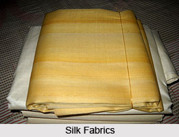
The agriculture in Murshidabad is supplemented by the cottage industries, which shares an equal importance in the economy of Murshidabad. However the silk weaving industry constituted to be the principal cottage industry in Murshidabad. The raw silk weaving has been growing prominently since the pre - historic times. However the silk industry in West Bengal is concentrated in Murshidabad. The brand "Murshidabad silk" is not only famous across India, but also has a great demand throughout the world. Sericulture industry is the principal agro-based rural industry in Murshidabad.
The livestock of cows, goats and buffaloes served the rural economy of Murshidabad.
Ivory carving is another industry of Murshidabad, which supports its economy. The ivory industry in Murshidabad is the only one of its kind in West Bengal. The other small-scale industries like the bell metal and brass utensils, carpentry, earthenware making, smithy, and pottery and bidi-making etc. served the rural economy.
The major trade in the Murshidabad is the silk fabrics. The ivory trading is also an important source of income of Murshidabad. About 99% of total production of ivory is exported, which draws a significant amount of Murshidabad`s income. The entire jute products are exported to the mills throughout the country. Among other things onions, pulses, oilseeds and vegetables constitute the main item of export. The handloom items and the woolen garments are the important items, which are being exported.
Handicrafts of Murshidabad District
Handicrafts of Murshidabad district are hugely acclaimed not only in the country but also across the globe. The history of these crafts is enrooted in the ancient past when these craftworks flourished under royal patronage. Since then, a number of artisans emerged in different parts of the district. Numerous artefacts are produced with a variety of materials such as ivory, wood, sholapith, bell-metal and silk. Meticulous and elaborate designs are furnished on the handicrafts, some of which takes a long time to complete.
 Ivory and Wood Handicraft
Murshidabad district is famous for its ivory and wood handicrafts having its origin in the times when Nawabs of Bengal had their court in the district. The industry flourished with the luxurious support of wealthy noblemen, the craftwork faced a crisis with the decline of the power of Nawabs. The ivory crafts were also admired during the British rule and were also exported to different parts of the country. Railway communication in that period helped a great deal to flourish this art. The artisans practicing Ivory and Wood handicraft once used to receive orders from the Government for supplying their artefacts in the exhibitions of England and other European countries. The main centres of this industry in the districts were located at Mathra, Ranshagorgram and Daulatbazar.
Sholapith Handicraft
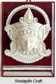
Another renowned craftwork of Murshidabad district is Sholapith handicrafts. Sholapith is white coloured spongy wood taken from a plant known as Sola. Sola mostly grows wildly in waterlogged marshy areas. Sholapith is in fact the core or cortex of the plant having one and a half inch of diameter. Although it resembles a thermocol, it is superior to it in terms of texture, malleability, sponginess and lustre. The testaments of this handicraft can be seen on the images of Gods and Goddesses during festivals and as beautiful backdrops in Durga Puja celebrations. Sholapith is meticulously carved with beautiful designs. The common motifs of this craft include floral designs, garlands, decorative head-wears of deities, elephant-howdahs, palanquins and peacock-boats.
 Bell Metal Handicrafts
Handicrafts of Bell metal and brass utensils are found mostly in Khagra, Kandi, Jangipur, Berhampore and Baranagar. They cater both the local as well as international markets. Dhulian is known for betel nut cutters and locks whereas iron chests are manufactured at Jangipur. However, there is a persisting problem in acquiring the raw materials by the artisans owing to the complicated formalities involved in submitting of applications.
Silk Industry
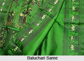
Baluchar town in the district is famous for Baluchari sarees. The saris have a base of silk with silk brocaded designs of varied hues. However strong contrast in terms of colour is avoided in these saris. Artisans from Muslim community are known for traditionally producing these saris with depiction of figured patterns, horse with a rider, court scenes and women smoking hookah. Floral borders surrounding the cone motif or the Kalka design are also common. Silk saris of Bengal are famed not only in the country but also in the international market.
Handicrafts of Murshidabad district have well captured the international markets too. Since ancient times, there is a huge demand for them worldwide and a major portion of these artefacts are exported. These handicrafts have greatly enriched the cultural heritage of the country and have also contributed in the bloom of handicraft industry of India.
Education in Murshidabad
The standard of education in Murshidabad in comparison to the other districts of West Bengal is quite comfortable. The literacy rate of Murshidabad as recorded in the last demographic survey of 2001, is 66 %, which is even more than the national average. Since independence the state Government, with the grants aided by the Center has been working to improve the standard of education in Murshidabad. Presently Murshidabad can be named as one of the educationally developed district in West Bengal.
There are about 3170 primary schools, 110 upper primary schools and 9 higher secondary schools operating throughout the district. The schools all are government run and are affiliated to the West Bengal Board. However the government has also implemented certain measures to provide at least the basic elementary education to the people in the rural area and bring them under the school system, thereby improving the standar6d of education in Murshidabad. Some NGO`s have also come up to provide help to the government in this solemn aim. However the literacy rate of 2001 makes the implemented measures of Government fairly successful.
The Government has proposed several funding schemes, to provide the dual assistance- the funds supplies monetary aid to those sustaining schools, where mainly the rural folk, who cannot pay the school fees come and also provide alternative empowerment strategy to the rural poor. The Government programs not only augment the educational growth in Murshidabad but at the same time provide alternative employment to the underdeveloped section.
Apart from the inducement of the system of elementary education in Murshidabad, government has also emphasized the growth of the higher education and vocational training in Murshidabad. There are 4 engineering colleges in Murshidabad and 1 Polytechnic College that accentuate the growth rate of vocational education in Murshidabad and also produce a large quantity of workforce. Since raw silk production is the principal money making sector in Murshidabad, government has highlighted the training of Sericulture. The Sericulture training institute here provided degrees to the students and with the educational insistence also produces an ample quantity of working individuals to the local silk industries.
Not only the technical institutions, there are colleges providing Undergraduate courses in all the streams of Arts, Commerce and Science. In recent times some private schools run either by the religious institutions or by any private concerns have been sprang up to supplement the educational development in Murshidabad, which was induced by the government since the independence of India.
Murshidabad is one of the districts, which has now become a prominent name in the educational arena of West Bengal.
Tourism in Murshidabad
 The tourism industry of Murshidabad centers round the rich cultural heritage of the district. The relics of the ancient buildings embody the civilization and the culture of the dynasties dominated here since the pre-historic times. The antiquity of Murshidabad helps the tourism industry to attain a thriving popularity. The interesting centers of Murshidabad fetch tourist throughout the year.
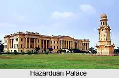
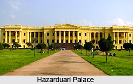
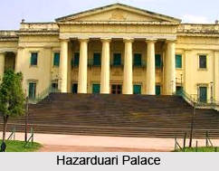
The Hazarduari palace, with thousand doors constitutes to be the principal tourist attraction in Murshidabad. This three-storied palace is a "nazrana" or gift of Duncan McLeod to the Nawab Nizam Humaun Jha, descendant of Mir Jafar. Following the European design, the palace building has thousands doors, 114 rooms, with 8 galleries, which are the principal attraction about the palace. The tourism industry in Murshidabad gets benefited with the construction of a museum. Presently the museum has an exquisite collection of antique materials, splendid paintings including the exhaustive portraits of the kings. Out of 2700 total arms, only a few are displayed. Vintage cars and the Fittan cars used by the families of the Nawabs are another attraction of the museum of Hazarduari palace. The Hazarduari palace is the clear manifestation of the Nawabi culture prevalent in Murshidabad. The library of the Hazarduari palace contains a collection of several books of rare kind. Though the library is not opened for the public, the tourism industry has the special permission to show the library to the tourist. The Hazarduari palace continues to hold a significant position in the tourism industry of Murshidabad.
Comparatively a small mosque, Medina is famous as a tourist destination for its designer floor. The mosque is the fabricated replica of Hazrat Muhammad`s tomb in Medina. The colorful tiled verandah of the mosque is important attraction about the mosque.
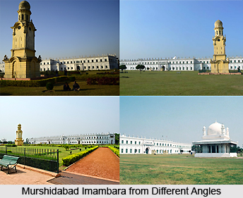
The tourism of Murshidabad is centering the Hazarduari palace. All the important tourist destinations, which are at the same time cultural representation of Murshidabad grows around the palace. The largest Imambara in Bengal perhaps largest in India Nizamat Imambara is built in Murshidabad by Siraj-ud-daulah. However the extant Imambara is not the original one. It is the reconstructed building after the original one was destroyed by fire.
The Wasef Manzil, the palace and residence of Nawab Wasef Ali Mirza adds another feather to the tourism industry of Murshidabad. In a close proximity of the Hazarduari palace, the marble staircases and beautiful statues of the Wasef Manzil are worth seeing.
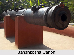
Two canons established by the Nawabs are important facets of the tourism industry in Murshidabad. The Bachawali canon and Jahankosha Canon are the principal canons depicting the Nawabi style of warfare. The Jafarganj cemetery is the burial ground of many famous personalities of Nawab dynasty.
Besides, Gharigarh, Chak Darwaja, Dakshin Darwaja etc are the major tourist centers of Murshidabad.
Visiting Places in Murshidabad
 Murshidabad, the last capital city of independent Bengal was named after Nawab Murshid Quli Khan, the Dewan of Bengal, Bihar and Orissa. It is situated on the banks of the Bhagirathi. A city of splendors & famous for its silk, was made capital of Bengal in 1717. The British shifted the capital to Kolkata in 1773. Plassey, where the historic battle was fought in 1757 between Nawab Siraj-Ud-Daula and lord Clive, of East India Company, is only 40 Km. South of Murshidabad.
Murshidabad, a town resonating with history, a town of Nawabs and Dewans, a town on the edge of the battlegrounds of Plassey where the history of India changed course. Murshidabad is a town so steeply entrenched in history that you can almost hear the tinkle of bells on the feet of dancing girls, the clink of wine glasses, the swish of houseboats sailing down the Bhagirathi, the rumble of cannons and the thumping of feet running down the ramparts of the palace.
Imambara
Parallel to the north face of the Hazarduari Palace, stands the Nizamat Imambara, built in 1847 AD. by Nawab Nazim Mansoor Ali Khan Feradun Jah, son of Humayun Jah, at a cost of more than 6 lacs, after the Imambara built by Siraj-ud-Doula had been destroyed by fire. It took only eleven months to construct this Imambara. The Imambara, which is the largest in Bengal, is perhaps the largest in India.
Wasef Manzil
This Palace was built by Sir Wasef Ali Mirza, Nawab of Murshidabad. This beautiful Palace was also the residence of Nawab Wasef Ali Mirza. This palace is very near to the Hazarduari Palace and is near the South Gate. The staircases made of marble and beautiful statues of this Palace are worth seeing. The entry fee is Rupee 1 (Indian currency) for Indian nationals.
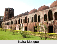
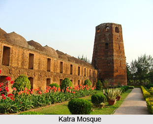
Katra Mosque
Katra Mosque is about one and a half km from Murshidabad Railway Station on the Berhampore-Lalgola Road. This imposing structure was built by Nawab Murshid Quli Khan in 1723-24 and it remains one of the most important tourist attractions. The gorgeous building with its huge domes and high minarets has a simple cemetery of the Nawab below the front staircase.
Jahan Kosha Cannon
Jahan Kosha, a huge cannon, is about 1 km of Katra. It was built in the early 17th century by craftsman Janardan Karmakar of Dhaka. Kadam Sarif is a beautiful mosque near Jahan Kosha said to contain a replica of the footprint of Hazrat Mohammad, the prophet. The canon is 17.5 ft long and weighs 16,880 lb., with a girth of 5 feet at the touch hole end. The diameter of the touch hole is one and a half inches, and that of the orifice is 6 inches.
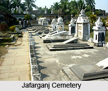
Jafarganj Cemetery
About half a mile from the Hazarduari Palace is Jafarganj the ruined palace of Mir Jafar. The Cemetery contains the tombs of the Nawab`s Nazim, from Mir Jafar to Humayun Jah. Mir Jafar`s father Syud Ahmed Nazafi, Alivardi Khan`s sister, Shahkhanum, Mir Jafar`s widows, Munni Begam and Babbu Begam, Mohamed Ali Khan, the brother and Ismail Ali Khan and Asraf Ali Khan, the sons-in-law of Mir Jafar, lie buried here. This cemetery was built by Mir Jafar, over an area of 3.51 acres.
Khosh Bagh
Khosh Bagh lies on the opposite banks of Bhagirathi. The grave of Nawab Alivardi Khan, Alivardi`s Mother, Siraj-ud-Doula and his wife Lutfannesha and other members of the Nawab family lie here. The Khosh Bagh cemetery is built over 7.65 acres of land.
Katgola
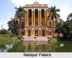
Mahimapur is half a km North of the Nasipur Palace. Here, the palace of Jagat Seth and the once famous Pareshnath Temple are now in ruins.
Katgola, the palace garden of Raja Dhanpat Singh Dugar and Lakshmipat Singh Dugar and their famous Adinath Temple were built in 1873, by Harreck Chand. The walls of this temple are also intricately designed. A typically Jain style of ornamentation lends a unique beauty to this Jain temple. It is about half a km South-East of Mahimapur. Though some of its glory has been lost, it still remains a major tourist attraction, chiefly because of the beautiful temple with an admirable work of stucco.
Best time to Visit
The best time to visit Murshidabad is in winter, between October and April, when the weather is pleasant enough for you to spend the day sight seeing. Carry cotton clothes for the day and a light woollen in case it is cool at night. Mosquito repellent and sunscreen are always handy.
Monuments in Murshidabad
 Monuments of Murshidabad are considered to be the major tourist attractions in the state of West Bengal which includes the renowned monuments at Hazaarduari and Katra where people from all parts of India and various other places from the world visit. Murshidabad`s history is synonymous with the history of Bengal in the eighteenth century. In the year 1704, the great Nawab Murshid Quli Khan transferred the seat of government here from Dacca, but it rapidly lost importance with the steady rise of English supremacy in Bengal after the Battle of Plassey in the year 1757. In 1772 Warren Hastings removed the courts from the city to Kolkata and in the year 1790, Lord Cornwallis transferred the entire revenue and judicial staff to the emergent new capital of the East India Company. Nevertheless, as the residence of the Nizams of Bengal it remained a vital centre of native power in Bengal at a crucial period of English expansion and also houses some of the beautiful architecture of that time.
Located at a distance of about one hundred and ninety six kilometres from the city of Kolkata, it is a small town with a very fine heritage of historical monuments from its days of greatness during the mid-eighteenth century. The Palace of the Nawab or Aina Mahal, designed by General Duncan Macleod of the Bengal Engineers, is loosely based on Government House, Kolkata. It stands in a large compound, together with several other buildings, enclosed by a wall. The palace, which is Italian in style, is an imposing edifice intended to convey the importance and power of the Nawab at a time when, in reality, that power was little more than nominal. It is a magnificent building over four hundred and twenty five feet long, with a banqueting hall of 290 ft. length, having sliding doors faced with mirrors, at the west end of which is a painting of Sir John Moore by Marshall. The centrepiece is a dome from which hangs a fine chandelier of 150 branches, presented by Queen Victoria, over an ivory throne with painted and gilded flowers. There is a fine circular Durbar room, an armoury and a library containing rare manuscripts. The zenana is placed to the right of the main entrance at the rear of the palace.
The Imambara stands within the same enclosure and holds the inscription `the Grove of Karbala`. Erected in the year 1847, in a similar European style to the palace, it is an enormous structure, the largest in east India. It replaces an earlier structure reputedly constructed by Nawab Siraj-Ud-Daulah and was erected under the instructions of Nawab Feredunjah. The facade is of two storeys, with a semi-circular central entrance arch with cusped surround flanked by Tuscan columns. Beyond is a high, plain dome.
The Medina is a free-standing pavilion located in between the Imambara and the palace. It is alleged to have foundations having earth from the Karbala at Mecca and is the only surviving remnant of Suraj-ud-Daula`s original Imambara. It is square in plan with a veranda, central dome and corner minarets. Also within the palace compound are two small 18th century mosques. The Safid Mosque is in painted stucco with basalt dressings. The Zarad Mosque is raised on a lower platform and bears a large central dome flanked by two smaller outer domes.
On the suburbs of the city is the Katra Mosque, completed two years before the death of the great Murshid Quli Jafar Khan, whose tomb is located here under the entrance of the courtyard. Now in ruins, it is an interesting structure with rectangular ornamental panels decorating the outside. Two of the original four corner octagonal minarets survive and may be derived from Mughal precedents, such as the Badshahi Mosque in Lahore, erected in the year 1674. A little distance off the road is the Great Gun, measuring 5.33 meters long, l.52 meters round at the breech, with a 15 centimetre calibre. It is one of the pairs, the other being in Dacca, and it is supported high above the ground on a Peepal tree which has grown up beneath it.
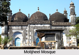
Situated at a distance of thirty two kilometres to the south of the city of Murshidabad is the Moti Jhil or Pearl Lake, believed to have formed as a result of the excavations for brick earth. It is a beautiful spot, but very little is there to be seen of the famous palace of Suraj-ud-Daula, where Robert Clive held the first revenue collection after the Battle of Plassey and where Warren Hastings and Sir John Shore later resided. To the east of the Moti Jhil is the Mubarak Manzil or Old Court House of the British East India Company.
Immediate opposite to the lake is the Khushbagh or Garden of Delight, the old cemetery of the Nawabs of Bengal. It consists of three separate enclosures. The outer one is entered from the east, past an old ruined ghat. The river wall is fortified and loop holed. In the outer enclosure are eighteen tombs. The central enclosure possesses the Tombs of Alivardi Khan and Siraj-ud-Daula, his son-in-law. Alivardi`s tomb is a square, flat-roofed structure having a central chamber encircled by an arcaded veranda, European in influence. The third enclosure contains a tank. To the right shore of the river, opposite to the main palace, is the Roshnibagh or Garden of Light. The Tomb and Mosque of Nawab Shuja - Ud - Din Muhammad Khan is located at this place. The tomb is a heavily restored, squat, flat-roofed structure set in a walled enclosure. To the north of the tomb is a small mosque constructed by Alivardi Khan, with engaged corner turrets and a central dome flanked by smaller vaults.
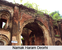
The Nizamat College, once reserved for the family of the Nawabs, is now open to all. At a distance of about one mile to the north of the palace is the Jaffarganj Cemetery, which bears the graves of all the Nawabs Nazim from the year 1765 to 1838. Directly to the west of the cemetery is the Mosque of Shah Nisar Ali, a plain, three-domed, rectangular affair. The Jaffarganj Deorhi was the residence of Mir Jafar before he became Nawab.
The city of Murshidabad contains a number of other notable buildings. The Chowk Mosque is at the central part of the town and is the major attraction. It is a large, seven-bay building with five graduated domes and two outer char-chala vaults flanked by slender minarets. The exterior is richly ornamented, with moulded stucco niches and arabesques. The Chowk Sarai Mosque is a small part of a wider complex intended as a sarai for travellers. Architecturally, it is based on the nearby Mian Holal Mosque, a fine affair with fluted, bulbous domes and detailed stucco ornament. Situated close to the Chowk Mosque is the Mosque of Nusari Banu, the wife of Murshid Quli Khan, famously constructed in the year 1735 but most of the buildings appear to date back to 1881. The tomb of Nusari Banu lies under the steps leading to the mosque.
Various notable mosques include the Mosque of Saif Allah, the Mosque of Abd Allah, the Mosque of Farhat Ali Khan, the Gulab Bagh Mosque, a picturesque ruin located 274 meters to the west of the Pil Khana, and the Qadam Sherif. The remains of the Mosque and Tomb of Azim Al-Nisa Begum, daughter of the great Murshid Quli Khan, and the Mosque and Tomb of Badr Nisa Begum are also of interest.
The Old Dutch Cemetery at Kalkapur has tombs dating back to 1721. In the Old Residency Burial ground is the tomb of Mary Hastings, the first wife of Warren Hastings, and her daughter. The tomb was restored in the year 1863. To day, Murshidabad is a prosperous district of the state of West Bengal having its head quarters in Berhampore. The city, apart from being famous for its monuments is well-known for the sarees and scarves.


