 Geography of Dhemaji District is mainly forted by arch shaped Arunachal hills on the North and the East. The district emerges from the foot hills and stretches to the Brahmaputra River with Subansiri one side and the river Siang on the other. The geography of Dhemaji District is basically plain area lying at an altitude of 104 metres above the sea level. The Dhemaji district is in a strategic location where steep slope of Eastern Himalayas abruptly drop forming a narrow valley, which widens towards the western side. Numerous drainage systems originating from the hills of Arunachal Pradesh flow through this narrow valley ending at river Brahmaputra. This region of Assam is prone to earthquake and shocks of various intensities are felt from time to time.
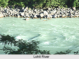
After the confluence the three rivers that are Dihing, Dibang and Lohit River from their hilly course exert tremendous impact of peak overflow at the eastern most corner of Dhemaji District, making it more exposed to annual flooding. Geographically, the area can broadly be divided into three district units and these are -
Piedmont zone: It is the foothill zone near the northern and eastern parts adjacent to Arunachal Pradesh.
Active flood plain: The zone near the river Brahmaputra and other major tributaries.
Low-lying alluvial belt: Covering the middle plain zone i.e. the saucer shaped built up zone. Innumerable muddy areas are common features in this zone.
The general and average soil character of cultivable land in Dhemaji District is mainly alluvial and composed of mixture of sand (rough to fine) and clay in varying proportions. The general geochemical characteristics of the soil are highly acidic. However, new alluvial soils formed due to inundation of land by river at intervals contain more percentages of fine sand that is less acidic. Such soils are often neutral and even alkaline. Abundant rainfall and excessive humidity through out the year favour cultivation of rice in the district. Further, vastness of low-lying land characterized by heavy clayish soil with a high percentage of nitrogen is also considered good for rice cultivation. The soil around the Subansiri and Ranganadi rivers are sand coated with sediment which is good for cultivation of winter crops, such as mustard, potato etc. The soils of this district can be classified into three different categories and these are the foothill soils, active flood plain soils near Brahmaputra River and the low-lying marshy lands. Thus, it is evident that the geography of Dhemaji District is mostly composed of plain lands with tremendous cultivation scopes.


