 Geography of Darrang District mainly comprises plain areas dotted by small hillocks. The northern part of this district is generally hilly and the southern part of the district is covered with forest and hillocks.
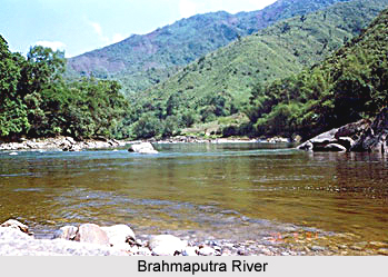
The elevation of Darrang District varies from 50 metres to 250 metres above the sea level and there is a constant slope from north to south. The Khalingduar Reserved Forest and Bhairavkunda area is at the peak of 150 to 250 metres height. Another thin belt of 100 to 150 metres high touches this and the central belt of the district is at around 50 to 100 metres and covers 40 per cent of the district. To the southern portion, this elevation gets further reduced. The Brahmaputra River maintains a level of 10 to 50 metres.
The geography of Darrang District can be divided in the low-lying plains, covered plains and hills. The hills are for the most part formed of gneissic rocks from which excellent building stone can be obtained. The plain is of alluvial origin and consists of sand and clay in varying proportions. Alluvial Soil, accompanied by another thin belt of older alluvium, covers the northern border; the rest of the district is covered by sandstone and shale. There is a small resource of coal near Udalguri. The Brahmaputra is the main river in the border of the south of the district on the east to west direction.
Other important tributaries of the Brahmaputra River are Barnadi, Nanoi, Mangaldai, Noanodi, Saktola, Dhansiri. These are the main rivers flowing through the Darrang District and the rivers are persistent in nature. Since the geography of Darrang District in north is at high level and hilly, and the southern part is low and plain, the district can be clearly divided into three belts regarding its ground water potential. The lean north belt of the district has a potential of 5 to 10 litres while the major central belt maintains a range of 10 to 25 litres. The south belt enjoys a generous 25 to 40 litres.
Darrang District has a sub-tropical climate with semi-dry summer and cold winter. Dust storms are common in the southern part of this district during February to April of the year because of the nearness of the area to sand loads of the Brahmaputra River. Basically, the two months that are December and January are the coldest months of the year. The maximum rainfall generally occurs during a period of four months starting in between May and June.
However, the drainage system of the Darrang District is inadequate in the monsoon. Recurrence of flood during monsoon due to heavy rainfalls in the district and neighbouring state of Arunachal Pradesh causes huge losses. The people of the district, who mainly depend on rainwater for their cultivation, are badly affected on one hand by floods and on the other hand by occasional dry spell.
The annual rainfall of the Darrang District varies from 1500 mm. to 2600 mm. Annual rainfall of this district in 1995 was 2449 mm. The highest rainfall occurs in small portion of the western part of the district including Tangla and Kalaigaon. This district of Assam receives maximum rainfall during the month of May to September. As per the variations of the temperature, again the district is separated into different belts in East-West direction. The middle belts are the hottest and the northern belts are coolest. Other parts of the region experience moderate temperature ranges. The northern part of the Darrang District consists of the vast tracts of muddy Tarai-land of Bhutan hills filled up by alluvial deposits forming light textured soils with a loose layer. Like for instance, the soil of the northern part of the district is slightly brown red and yellow. Thus, all these features indicate that the geography of Darrang District comprises huge plain lands with humid and congenial climatic variations.


