Introduction
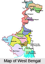
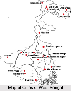
Bardhaman district is a district located in West Bengal. The main town of the district is Bardhaman. Bardhaman District covers an area of 7024 square km, and has a population of 6,895,514 (as per the 2001 census). The Birbhum and the Murshidabad districts, on the east by the Nadia District, on the southeast by the Hooghly District, on the southwest by the Bankura and the Purulia districts, and on the northwest by the state of Jharkhand, surround it on the north. The district consists of six sub- divisions, namely Asansol Sadar (North), Sadar (South), Durgapur, Kalna, and Katwa. It was among the first districts to have a 100% literacy rate.

History of Bardhaman District
Barddhaman is located on the banks of the Damodar River. It was named after the 24th Jain monk, Tirthankar Mahavira Bardhaman. During the Mughal rule, its name used to be Sharifabad. Bardhaman came to be existed as a separate administrative unit, when Sangam Rai established Bardhaman Raj in 1657.The district owes its historical importance as a head quarter of the maharajas of Bengal & during the reign of Jahangir the region was also known as the Bandh-e dewan (means the district headquarter).
In the 17th-18th century, Raja Krishnaram Ray, belonging to a merchant family from Punjab, established the zamindari of Bardhaman on a farman issued by the Mughal Emperor Aurangzeb. The Rays went on to rule Bardhaman till 1955. From Bardhaman District there are various relics of Stone Age have been found in and they are similar to the finds of the stone weapons and other relics discovered in Singhbhum, Purulia, Dhanbad and Bankura districts. One of the totems of the Bauris who were the original inhabitants of Barddhaman and are stiff a formidable so-called lower caste has dog as their totem. The Bauris are supposed to be rough and rude. A large number of stone images of the different Tirthankar have been discovered in Burdwan district.
The founder of the Bardhaman Raj, Sangam Rai belonged to the Kapoor Khatri family of Kotli whose descendants served both the Mughals & the British Raj. Therefore Bardhaman was an important site for both the Mughals & the British. The native rulers ruled the district most of the times though under the direct control of the Mughals & the British Raj.The great prosperity of the Raj was due to the excellent administrative management of Maharaja Mahtab Chand during the turmoil of the Santhal Rebellion, for which he was rewarded with a grant of arms in 1868 & a personal acknowledgment of 13 guns in 1877. Maharaja Bijai Chand Mahatab consecrated on the throne of Bardhaman, who chiefly earned distinction due to his indomitable courage. The native rulers of Bardhaman were mainly known for their sheer allegiance to the British Raj.
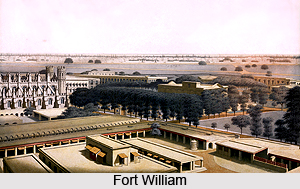
Burdwan was enriched with the art and culture of Gupta age and during the rule of the Sena kings also Bardhaman District was flourished. During the medieval period, Burdwan was an important administrative headquarters. It is here that Sher Afghan, the unfortunate husband of Nurjehan lived as a Jagirdar. Jehangir was anxious to bring over Nurjehan to his harem and had deputed Kutubuddin to Burdwan as his Subedar. Ultimately both Sher Afghan and Kutubuddin were killed in a fight somewhere near the present Burdwan railway station. The two graves of Sher Afghan and Kutubuddin lying side by side in Burdwan not only recall history but remind rudely as to what man can do to satisfy his lust.
It is again Bardhaman that gave sanctum to the intellectual and spiritual divine, Pir Baharam when he had to leave Delhi due to the machinations of Abul Fazal and Faizi in Akbar`s time. A Hindu divine Jaipal came in close touch with Pir Baharam land both enjoyed a mutual spiritual companionship. Bardhaman witnessed, experienced and survive numerous violent conflicts and is visited and dominated by the notables for ages. From Raja Todarmal to Daud Karnani, from Sher Afgan and Qutbuddin to Ajimuswan and even Shah Jahan, when he was still a rebel, had dominated the region, which makes it a land of multi faceted cultural legacy. The temples (deuls, mainly of rekh variety) here embody the Buddhist culture. Various mosques and mandirs (old Hindu temple) bear the signs of Muslims and Hindu Culture at the same time. The Hindu mandirs are mainly the symbols of the Vaishnava and Sakta community.
Though the native rulers were never disloyal to the British Raj, they struggled their best for the economical & cultural upliftment of their native land and during the reign of Mahtab Chand Bahadur & Bijoy Chand Mahatab, the region was affluent both culturally & economically. The principal educational institute, Bardhaman Raj College was established almost under the benefaction of the maharaja`s estate. They were the ardent patron of art & culture. Poets like Sadhak Kamalakanta, composer of devotional songs, Kashiram Das, poet & translator of the Mahabharata etc. are the products of their solemn patronage. The town also existed as the important seat of the north Indian classical music.
Geography of Bardhaman District
Geography of Bardhaman District is mostly dealing red soil rich in iron and there exists anthracite and bituminous coal. Bardhaman district in the state of West Bengal extends from 22 degrees 56 minutes to 23 degrees 53 minutes North latitudes and from 86 degrees 48 minutes to 88 degrees 25 minutes East longitudes. Lying within Burdwan Division, the district is bounded on the north by Dumka (of Jharkhand), Birbhum district and Murshidabad, on the east by Nadia district, on the south by Hooghly, Bankura district and Purulia district and on the west by Dhanbad (of Jharkhand) districts. The western boundary of the state is formed by the Barakar River. The Ajay River separates Birbhum and Dumka to the north with the exception of a portion of Katwa subdivision; the Damodar River forms a southern boundary with Purulia and Bankura, while Bhagirathi River forms the main eastern boundary with a few exceptions. The maximum length from east to west is 208 Km while the maximum breadth from north to south is 112 Kms.
Bardhaman district with its varied tectonic elements and riverine features is a transitional zone between the Jharkhand plateau which constitutes a portion of peninsular shield in the west and Ganga-Brahamaputra alluvial plain in the north and east. Towards the south, the alluvial plain merges with Damodar-kasain-Subarnarekha deltaic plains. The river system in Bardhaman includes the Bhagirathi River and Hooghly River in the east, the Ajay and its tributaries in the north and the Dwarakeswar, the Damodar River and its branches in the south-west. Besides, there are innumerable Khals and old river beds all over the area. There are many tanks, wells, canals and swamps which are found all over the district.

The Durgapur barrage and Mithon dam have formed two large reservoirs at the south-western and western periphery of the district. Average temperature in summer is about 30 degrees Celsius while in winter it is 20 degrees Celsius. And average rainfall is 150 millimetre. The cold season starts from about the middle of November and continues till the end of February. March to May is dry summer intervened by tropical cyclones and storms. June to September is wet summer while October and November is autumn.
Different types of soil are seen existing within the different topographical and geological conditions within the Bardhaman district. In the west coarse, gritty soil blended with rock fragments is formed from the weathering of pegmatites, quartz veins and conglomeratic sandstones. This soil is reddish in colour, medium to coarse in texture, acidic in reaction, low in nitrogen, calcium, phosphate and other plant nutrients. Towards the east alluvial soil attains an enormous thickness in the low level plains to the east. This alluvial soil is formed of alluvium brought down by the Ajay, Damodar, Bhagirathi and numerous other rivers. These soils are sandy, well drained and slightly acidic in nature.
Bardhaman scores quite well in terms of mineral reverve. The Raniganj coal field found here was the birthplace of the Indian coal industry. Apart from coal, the other important mineral reserves found in the district are iron-ores, calcium carbonate, abrasives, silica bricks and moulding sands, glass sands, building materials, manganese, bauxite, laterite etc.
The forest areas of the district are chiefly situated in the lateritic and red soil high lands in the Aushgram PS of Sadar Subdivision and in the Asansol subdivision. In Ausgram P.S. the forest areas are interspersed with paddy fields. The Durgapur forests are continued in the Birbhum district beyond the Ajay while the forest area in the Asansol subdivision forms a part of the forest area of Dumka District of Jharkhand. Vegetation in the district includes neem, amlaki, coconut, palm, mango, sal, mahua, Arjun etc. Common acquatic and marsh weeds are found in the jheels and swamps in the eastern parts of the district.
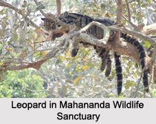
Animals found in the district include leopard, wolf, hyena, jackal, wild pigs, monkeys, poisonous snakes such as the cobra, karait and the deadly Russel`s viper. Among the birds and fowl found here are pea-fowl, jungle-fowl, jungle crow, house crow, treepie, common babbler, common jora, gold-fronted chloropsis, red-vented babul, red-whiskered bulbul, red spotted bluethroat, brown-backed robin etc. The low-lying swampy areas of Bardhaman being in line of migration provide a very good sheltering place for the migratory birds in winter.
Economy in Bardhaman District
Bardhaman is privileged in both agriculture & industry. Hence both supplement the economy of the district. On a whole about 58% of the population draw their living from agriculture and remaining 42% of the district`s economy is supported by the non-agricultural sector.

The district locates between the Ajay & Bhagirathi Hooghly Rivers; hence the tract is made up of the alluvial soil carried by those rivers, which is highly favorable for cultivation. The optimal rainfall here is supplemented by the effective network of irrigation facilities (Government canals, tank, wells etc), which improved the agriculture of the district to a large extent. The agricultural products, produce in abundance at the same time, serving the economy by exporting, meet the everyday need of the district itself.
"The granary of West Bengal", Bardhaman mainly accounts for the production & trade in rice. Rice is exported to the different districts within the state & even in the neighboring countries. Nearly all the varieties are produced in this region, which can be primarily classified into 3 types depending on the seasons they are cultivated - Aus or autumn, Aman or winter and boro or the summer rice. Though paddy covers the maximum of the gross cropped area, some cash crops like jute, potato, sugarcane and oilseeds are cultivated in the subsidiary areas.
Having an advantageous topographical feature, the region was developed as an agriculturally prosperous land from the primeval times. The implementation of the Damodar Valley Project in 1953 induced a scientific dimension to the standard of cultivation of the district.
The optimal rainfall with tropical humidity of Bardhaman is supportive for the cultivation of the horticulture crops, which covers a large number of fruits, flowers& vegetables. As these are perishable in nature, they required proper maintenance. The NCDC (National Co-operative Government Corporation) is trying to promote the standard of the horticulture by developing the post harvest infrastructure like cold storage, food processing, packaging& marketing which contribute a significant part to the district`s economy.

Predominantly an agricultural district, Bardhaman is no less famous for its industries. The industries here is supported by the considerable storage of minerals in the extensive area of the district & also by those imported from the neighboring districts and states like Bihar, Orissa, Assam etc. The vast chunk of industries in Bardhaman, comprise the largest belt of industry in West Bengal.
Embracing the Asansol & Durgapur subdivision, the wide belt of industry grows up. In spite of being a rural set up primarily, the industrial region of Bardhaman signifies an urbanized economy. The availability of infrastructure & favorable climate, led the economic planners to set up industries in Durgapur & Asansol including the adjoining areas. The traditional industrial base like coal, iron ore have undergone a rapid diversification and new industrial ventures, which include mainly heavy engineering, coal-based chemicals & coal-based thermal power plants are now growing up with equal importance of the customary iron and steel industries of the region. The Damodar Valley Project at the same time supplementing the irrigation purpose, play a dominant role in the sustained program of hydroelectric power generation which induces the effective industrialization & modernization of the district.
The industrial products have great demand all over the districts & sufficient amount of profits is drawn from the export of these products even in abroad. The industrial area of Bardhaman was a principal site of investment of the foreign aid since the post independence period, which also helps, for the development of urbanized industry based economy. Between 1955 to 1965, a series of large & small-scale industry grew up in Durgapur pivoting the Steel Plants in Durgapur.
(i) Durgapur steel plant: - Utilizing the British Technology, the plant first started the construction works in furnace and produces about 1 million tonne of steel. It was the primitive base of Iron & Steel industry in Bengal, which also accounts for large quantity of export.
(ii) Durgapur Alloy Steel Plant:-In 1965, Alloy Steel Plant utilizing the Japanese investment of 70 crores and Canadian know-how, Alloy Steel Plant came to be existed, which produced the steel of its own kind and exports the largest amount of alloy steel of the country till date.
The bi products of steel production naptha is an important base for fertilizer production which helps for the growth of Durgapur Fertilizer Project, which is the first plant of its own kind, maintained by FCI (Fertilizer Corporation of India) in West Bengal and sixth in the export of its products in the country.
Durgapur Project Limited is an integrated whole of several plants - (i) Coke Oven with its bi-products and tar distillation plants (ii) a thermal power plants, which not only serve the domestic needs but also support the country`s economy to a large extent.
Moreover a gas line between Durgapur & Calcutta and a new industrial complex are under construction to offer modern facilities to the currently existing industries, thereby helping the country's economy. The chief feature of the industrial belt of Bardhaman is that the byproduct of one is enough for the breeding of some other plants. Hence the industries not only export their items but also meet the domestic requirement.
The Asansol industrial belt has grown up with IISCO (Indian Iron & Steel Industry) in Kulti-Burnpur (established in1871) at its core. It was the oldest unit of manufacturing the pig iron & iron casting in India. It is through this industry, India started its export operation in the abroad in the pre- independence period.
Chittaranjan Locomotive, the government undertaking is responsible for supplying locomotive parts in all over the country. Various other industries have assisted the development of Chittaranjan Locomotive.
The enormous reserve of minerals mainly coal in the extensive area of Raniganj forms the wide belt of ECL (Eastern Coalfields), which supplies the raw materials for the domestic industries and also to the different states all over the country.
Several cottage Industries have also grown up in the interior areas, which supports the rural community. Making of iron utensils & cutlery, dairy, gold & silver smithy, making of clay utensils and pottery etc are the principal occupation of rustics & also support their daily requirements.
Not only by exporting, the industries here supply raw materials to the domestic plants, for that they do not require importing those; hence a bulk of money is saved which is otherwise required for the import cost.
Industries in Bardhaman District
Industries in Bardhaman are plenty and involve numerable significant industries which are concentrated in the Durgapur Subdivision and Asansol Subdivision. The development of modern industrial towns of Chittaranjan and Durgapur has ensured the urbanization of the Bardhaman district, thanks to the different five year plans. Raniganj, Kulti, Burnpur and Asansol are important industrial centers today. Steel, iron and coal are amongst the essential traditional local industries of Bardhaman. Thermal power programmes, fertilizers and hydro-electric power plants constitute the important industries which have strengthened the local economy of this region of the country.
Indian Iron and Steel Company (IISCO)
Indian Iron and Steel Company (IISCO) is renowned for being the very first unit in the country which manufactures pig iron and iron casting in the country. Initially, IISCO was known as the Bengal Iron Works. Public Works Department of the Government of India undertook the supervision of the works started by IISCO in the year 1880 to 1881. The transfer of ownership occurred in 1936, after which the company assumed the new name of Indian Iron and Steel Limited or IISCO.
Durgapur Steel Plant
Durgapur Steel Plant is situated on the river banks of Damodar. The very first blast furnace of this plant was built on 29th December, 1960. In 1957, the construction of Durgapur Steel Plant commenced. British technology was employed in its functioning. This plant contains its own washery. The Research and Control Laboratory of the Steel Plant is responsible for controlling and enhancing the quality of the products created here. The products manufactured here involve rods in coils, crossing sleepers, electric resistance welded pipes and several others.
Durgapur Alloy Steel Plant
Set up in the year 1965, the Alloy Steel Plant was constructed in order to manufacture engineering steels, alloys and some other products. The main portion of the plant was inspired by Japan and the technical details were supplied by a Canadian company. The process of vacuum degassing is performed only in the Durgapur Alloy Steel Plant.
Durgapur Fertilizer Project
Durgapur Fertilizer Plant is known to be the very first fertilizer plant in the Eastern Indian state of West Bengal. Indian engineers had designed this plant with the help of foreign collaboration. Its main product, Naphtha is supplied by the Indian Oil Corporation.
Durgapur Project Limited
This organization is a West Bengal Government undertaking. The various sections of the Durgapur Project Limited include a coke oven plant, a thermal power station, a brand new industrial unit which offers modern amenities and a gas line which is present between Calcutta and Durgapur.
Chittaranjan Locomotive
Chittaranjan possesses a locomotive factory which is located at a distance of nearly 7 miles from Asansol. This is situated near Mihijam Station. There are numerous local factories which have enabled the steady growth of the locomotive industry of Bardhaman district.
Hindustan Cables Limited
This company is an undertaking of the Government of India. It is the one and only Indian organization which is known to produce telephone cables and coaxial cables in the country. The products manufactured by Hindustan Cables Limited have earned good recognition in India.
Bardhaman district is reputed for its multiple kinds of iron utensils. Cutlery items are created in the area of Kanchannagar, which is about five kilometres from the western portion of Bardhaman. Begunkhola, Bonpas and Dainhat are well-known for their production of bell metal utensils and brass metalware. Other industries involving silver, gold, clay image creating, cart-making, Pottery, bamboo and cane crafts, oil crushing, stone carving, handloom weaving, etc. Cottage industry also thrives in this region and Katwa Industrial Centre is the most significant area for this industry. Kalna, Purbusthali and Manteswar are the ancient area which specializes in various crafts of cottage industries.
Demography in Bardhaman District
As per the 2001 census, Bardhaman has an average population of about 285,875 of which 52% constitute the males & 48% the female. The district has the literacy rate of about 77%, higher than the national average (59.5%) with55% male & 45% female literate, 9% of the population is under the age of 6years.
Being a Hindu district primarily, most of the inhabitants here are Hindus. However, in the interior part of the district there are some Muslims. Bengali is the mostly spoken language though some local languages are also in practice among the people in the remote parts.
Education in Bardhaman District
A bulk of cultured and sophisticated people inhabits the urbanized district, which is perhaps the chief cause behind the development of schools and colleges and the standard of education in such an extensive scale. Presently the district is the glorious seat of the academics. A bunch of schools and colleges here is supplement by a number of colleges intended for vocational training. Moreover the Burdwan University is a famous name in the national educational panorama.

University of Bardhaman started in 1960 with Sukumar Sen, an ICS as the first Vice Chancellor. The University awarded 4 star statuses by NAAC, started functioning in 1960, having its jurisdiction over 30 undergraduate colleges spread over 5 districts of the state. Presently the University has several departments including the Arts, Science, Commerce, Law & Engineering.
Apart from the schools undertaken by the West Bengal Government, there are several other schools, which are under the direct control of the Central Government. Bardhaman Municipal High School and Bardhaman Town School are the prominent schools of the West Bengal government offering the 3 streams of Arts, Science & Commerce. Several CBSE & ICSE schools have their branches in this district. Kendriya Vidyalaya & the St.Xavier`s school are the notable schools under the dominion of Central Government here.
Burdwan Medical College, Burdwan Homeopathic College, University Institute of Technology (Polytechnic College), University Law College etc are some of the colleges under the University intended to the vocational training. The district is now making a continuous progress in the field of vocational education. Burdwan Raj College and Maharaj Uday Chand College are the undergraduate Colleges under the Burdwan University.
Tourism in Bardhaman District
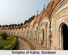
Some of the tourist spots of Bardhaman District are Curzon Gate, 108 Shiva Mandirs, Tomb of Sher Afghan, Golapbag, Hawa Mahal, Ramana Bagan, Bijoy Bahar, Meghnad Saha Planetarium, Sarbamangala Temple, Kankelshwari Kalibari, Kalna and Maithon.

Bardhman District was the domicile of the Muslim dynastical rulers in the medieval times and the British Empire in India. Hence the historical importance of the place is quite considerable. There are several tombs and dargas enumerate the spirit of Muslim Culture side by side with the Hindu culture prevalent in the region. Pirbaharam Shikiha Khwaja Anwar Berh, Shah Alam`s Darga are the religious and cultural places of the Muslim civilization, that once inhabited the region. During the rule of British Government in India, the Hindu monarchs rose into provisional powers as the representative of Dual Government. During the rule of Hindu kings, the palaces and gardens of the Maharaja Golapbag, Nawab Hat, Ramana Bagan, and the Palace of Burdwan Kings are built.
Burdwan District also has numerous places where the tourist can take peace while they will walk in the boulevard of green dreams. The Curzon Gate was built in honour of the visit of Lord Curzon in the Burdwan District. Golap Bag, or the Garden of Rose, of Bardhaman, is a favourite tourist place in this district. The Golap Bag is the Botanical and Zoological garden established by the King Bijoy Chand Mahatab in 1884. The famous botanist Dalton Hooker, an eminent Botanist listed about 128 types of trees.
Meghnad Saha Planetarium is the second planetarium after Kolkata, which is entertaining the people of Burdwan District. The Tomb of Sher Afghan, the last of the Afghan Jagirdars in Bardhaman District, is located at Pir Beharam near Rajbati (Burdwan Royal Palace). Some of the popular tourist spots are Uddharanpur, Kogram, Kalna Raj Bari, Chupichar, Deer Park, Nachan Bird Sanctuary, Maithon Dam, Kanchanngar, Deulia, Singi, Jima Masjid, Tarakshya Temple, Mankar, Pandabnath Temple, The Dhibi of Pandu Raja, Amrargarh Fort.
Pilgrimage Tourism of Bardhaman District Description: Pilgrimage Tourism of Bardhaman District is attracted not only by the history lovers but also the nature lovers and the worshippers of Shiva and Kali This district is comprised by terracotta styled temples and also the shakti peethas.

Pilgrimage Tourism of Bardhaman District was the abode of the Muslim rulers and the British Empire in India. Hence the historical importance of the place is quite considerable. Several tombs and dargas enumerate the spirit of Muslim Culture side by side with the Hindu culture prevalent in the region. Pirbaharam Shikiha (tomb of Sher Afgan, subject of Akbar the great and Subedar of Bengal Municipality), Khwaja Anwar Berh (tomb of Khwaja Anwar, famous Mughal Warrior), Shah Alam`s Darga (a building of archaeological interest built by Subedar Murshid Quli Jafar Khan in 18th century)etc are the religious and cultural site of the Muslim civilization once inhabited the region.
The temples of the Bardhaman District evidently signify the spirit of the prevalent Hindu Civilization and also famous for their rare artistry. Babladihi is a temple of lord Shiva, whose principal attraction is the architectural trappings over the walls, which are believed to be of the Pala age. The idol itself is the lively representation of the art and architecture of Pala Dynasty. Siddheswari Temple is known for its Terracotta carvings. One of the major attractions here is the pattern of the temple. The Shiva temple here surrounds the temple of presiding goddess, Siddheswari Ambika. Baikunthanath Siva temple, established by Brajakishori, is renowned for its terracotta art.
Shyamarupa Temple, owes importance chiefly for its antiquity. Here the 10-armed idol of Shyamarupa echoes the Hindu religious belief that goddess Durga is 10-armed. Temple of Icchai Ghosh and Rarheswar temple is essentially important for their architectural works. Unlike the temples of Birbhum, which attracts only the pilgrims, the temples in Bardhaman, well known for their artistry fetch a mass of tourist other than the pilgrims. Churulia, the birthplace of Kazi Nazrul Islam is presently famous for its stone carvings.
As Bardhaman is an industrially flourishing district the chief attraction provided by the urbanized set up of the district. The dams and bridges developed for the industries of the have great potential in the Tourism Scenario. The Maithon dam and the DVC (Damodar Valley Corporation) project encircle not only the district of Bardhaman but also some parts of Bankura District. The area encompassing those dams offers a beautiful sight.
The temples and palaces of the region are the cipher of those kings once dominated the land, which adds a charismatic charm to the dignity of the place. The Rajbati Complex of the University was originally the place of Maharaja Burdwan. Kanchannagar is believed to be the headquarter of Sasanka, where he established the temple of Kankleswari designed after the structure of human skeleton. Deulia is famous for the beautiful temples, constructed, following the "Rekh" temples of Orissa.
Udharanpur(famous for its old and religious fair) and Kogram ( at the confluence of the Ajay River and Kunur River, is believed as one of the Satipitas) add some religious importance to the place. Temples of different gods in the interior section of Kalna Rajbari is undoubtedly of profound historical worth.
Visiting Information
Burdwan District can easily be accessed with all the major railway and road way stations. Burdwan District is well-connected with major railway junctions. Burdwan District also has an extensive road network with inter-state corridors. As Burdwan District lies 95 kilometres, the buses and other vehicles can easily ply from Kolkata to Burdwan.