 Darrang District is an administrative district with its headquarters located at Mangaldai in Assam. This district covers an area of approximately 3481 sq km. Darrang District shares the border with Bhutan and Arunachal Pradesh. People of various communities live here with peace and harmony. Darrang District is in the central part of Assam. Darrang District has a well planned administration. Deputy Commissioner is in charge of the entire administrative set-up of this district. Several officers assist him in the discharge of his functions. Additional Deputy Commissioner, Sub-Divisional Officer (Sadar), Extra Assistant Commissioner, Election Officer and more, aid him. Darrang District has only one sub-division, namely - Mangaldai (Sadar) sub-division and one Mahkuma Parishad, namely - Mangaldai Mahkuma Parishad. Each development block constitutes one Anchalik Panchayat. Thus, Darrang District consists of seven Anchalik Panchayats. Moreover, there are 79 Village Panchayats and 554 Revenue villages in Darrang District.
History of Darrang District
History of Darrang District, the name Darrang originated from the Sanskrit language term `Dwaram` meaning `Duar` or a pass. Several archaeological sites like Narikali, Bijulibari, Lakshimpur District, Mathajhar, Murhadeor, Tamreswar, Bhairavkunda, Dhawalpur, etc., point to the hoary past of this region. No ultimate historical evidences about the district are available. However, some archaeological researches suggest that Darrang District became popular only after the medieval period after the up rising of King Biswa Singha Naranarayana. The rich history of this district is reflected in the culture of Darrang District.
Geography of Darrang District
Geography of Darrang District is basically spread over vast plain land with several small hillocks. The northern portion of this district of Assam is mostly hilly and the southern portion is surrounded with forests and hillocks. The altitude of Darrang District ranges between 50 metres to 250 metres above the sea level.
Demography of Darrang District
According to the Population Census in 2011, the Darrang District had population of 908,090 of which male and female were 472,134 and 435,956 respectively. The population of Darrang District constituted 2.91 percent of total population of Assam. The population density of Darrang district is 491 people per sq. km. Darrang district administers 1,849 square kilometres of areas. The average literacy rate of Darrang in 2011 was 64.55 percent. The male and female literacy were 68.36 percent and 60.40 percent respectively. The total literates in Darrang District were 489,559 of which male and female were 270,036 and 219,523 respectively.
Economy of Darrang District
The economy of the Darrang district is agrarian where the majority (about 85 per cent) of the population is engaged in agriculture and allied activities. Agriculture is the main source of income of the people in this district. Moreover, Sericulture in Darrang district is an age-old industry. It helps as a part time occupation to a huge mass of economically weaker section of the society residing in the rural area of the region. Thus, sericulture has gathered a considerable importance in the socio-economic life of the society. Production of fish in the district is quite negligible. Tea is the only plantation crop of this district.
Tourism in Darrang District
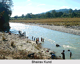
Tourism in Darrang District is popular among the travellers from different parts of the world. There are numerous places of interest in this district. It offers both pilgrimage and leisure tourism to the visitors. Like for instance, one of the prominent places of attraction in this district is Bhairavkund. Bhairavkund is a famous picnic spot in the region. It is defined as a must visit place of the region. The other important towns in Darrang District are Udalguri, Tangla, Rowta, Kharupetia and Baihata Chariali.
To reach Darrang District from outside Assam, one has to reach Guwahati by different modes like air, train or road. There are regular public buses plying from Guwahati to Mangaldai. This district is well connected by road, and water transport system. In addition, the district is benefited by the water transport system due to its northern boundary being covered by Brahmaputra River. There is steamer service from Upper Kurua to Guwahati. The nearest airport is at Azara, (Guwahati), at 77 kms from the district headquarters, Mangaldai. There is another Airport at Saloni (Tezpur), which is at 110 kms east of Mangaldai.


