 Cachar District is an administrative district of Assam with its headquarters at Silchar. Cachar District covers a total area of 3786 sq km. The official language of this district is Bengali language with majority of people residing in this district primarily speak Bengali language as well as Sylheti language. The district headquarters, Silchar is considered as one of the significant business centres of the state. Cachar District is bounded on the North by Barali and Jaintia Hills, on the South by Mizoram, on the East by the Hailakandi district and Karimganj district. It is considered as one of the oldest districts of this state.
History of Cachar District
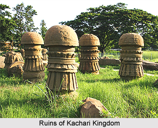
The name of the Cachar District was derived from the Kachari kingdom. Initially, Cachar district was a part of this kingdom that included the adjacent Karimganj and Hailakandi districts of Assam. The Cachar District is situated in the southern region of Assam. The British East India Company formed this district in 1830 after the seizure of Kachari Kingdom. Further, in the year 1854, northern portion of Cachar was seized and tagged to the district. The former North Cachar sub-division was transformed into a separate district in 1951.
Geography of Cachar District
Geographically, Cachar District is not situated in an advantageous position but strategically, this district is considered as important. Cachar District is the gateway to the neighbouring state of Mizoram and also to the western parts of Manipur and is principally surrounded by hills in all the three sides. Cachar District is located at a longitude of 92 degrees 24 minutes east and 93 degrees 15 minutes east and latitude of 24 degrees 22 minutes north and 25 degrees 8 minutes north.
Demography of Cachar District
According to the Population Census in the year 2011, Cachar had population of 1,736,319. Out of which the male and female were 886,616 and 849,703 respectively. The population of Cachar District constituted 5.57 percent of total population of Assam. The population density of Cachar district is 459 people per sq. km. Cachar district administers 3,786 square kilometres of areas. The average literacy rate of Cachar District is 80.36 percent. According to the gender classification, the male and female literacy were 85.85 percent and 74.62 percent respectively. The total literates in Cachar District were 1,196,892. Out of which the males and females were 652,827 and 544,065 respectively. Concerning about the Sex Ratio in Cachar District, it stood at 958 per 1000 male compared to 2001-census figure of 945. The average national sex ratio in India is 940 as per latest reports of Census 2011 Directorate. In 2011 census, child sex ratio is 955 girls per 1000 boys compared to figure of 961 girls per 1000 boys of 2001 census data.
Tourism of Cachar District
Some of the tourist destination spots in Cachar District are Kachanti Temple, Bhuban Hills Shiva Temple, Darul Uloom, Sal Ganga, Sonai Park, Arunachal Ashram, Khaspur and many other places of tourist attractions. Cachar District is well connected by road with Guwahati via Jowai Shillong route. In fact, it is the only road link direct from Guwahati linking it with the rest of the world. The Jowai Badarpur road also connects Mizoram, Tripura and some parts of Manipur. The Silchar- Imphal road connects Cachar with Manipur. The Silchar Haflong road connects Haflong, Lumding and other parts of Assam. The railway network touches important places of Barak Valley. The Lumding Badarpur section of the railways is the most vital link of Cachar, Mizoram and Tripura with the rest of the country. The line is built up through the hilly terrain of North Cachar Hills passing through 36 tunnels. Cachar District has its own airport at Kumbhirgram, which is near about 30 km away from Silchar town. It serves as the major communication link for the people of Cachar District. The Air Service operates flight services in several routes like Silchar-Imphal, Silchar-Kolkata and Silchar-Guwahati from this airport.
The Cachar District also has several recognized educational institutions and it also offers proper health care services to the people.


