


 Indian Himalayan Regions cover up a huge part along the country's northern frontiers and span several Indian states like Jammu and Kashmir, Uttarakhand, Himachal Pradesh, Sikkim and Assam. The Himalayan mountain range extends along India's northern boundary. ‘Himalaya’ is a Sanskrit word which means "the Abode of Snow". The term 'Himalaya' was coined by the pilgrims of India who traveled and explored this region in the ancient times. It is important to note that the division of the Indian Himalayan Regions is entirely based on the various ranges and not on the boundaries of the states. Given below are the various Indian Himalayan Regions. Indian Himalayan Regions cover up a huge part along the country's northern frontiers and span several Indian states like Jammu and Kashmir, Uttarakhand, Himachal Pradesh, Sikkim and Assam. The Himalayan mountain range extends along India's northern boundary. ‘Himalaya’ is a Sanskrit word which means "the Abode of Snow". The term 'Himalaya' was coined by the pilgrims of India who traveled and explored this region in the ancient times. It is important to note that the division of the Indian Himalayan Regions is entirely based on the various ranges and not on the boundaries of the states. Given below are the various Indian Himalayan Regions.
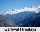
Kashmir Himalaya The northern boundary of Kashmir is formed by the great Himalayan axis that runs southeast from Nanga Parbat to Nun-Kun. Beyond this, to the northeast lies Ladakh, to the east lies Zanskar and towards the southeast lies Kishtwar. They all form part of the state of Kashmir, but they hold separate geographical entities for the mountaineers and have parts of the Himalayan Mountain range. Ladakh Himalaya Ladakh Himalaya comprises of the ladakh range to the north of Leh. This range is considered to be a significant part of the Trans-Himalayan range which joins the Kailash range in Tibet. Two significant passes of the region are Khardung La and Digar La. Zanskar Himalaya Zanskar Himalaya comprises of the Zanskar Range which is located north of the main Himalaya. This range separates Zanskar from Ladakh. Zanskar is positioned south of the Ladakh district and is surrounded by high mountains. The range is a part of the Tethys Himalaya. It has an average height of about 6,000 m (19,700 ft). Fatu La is one of the main passes of the region. Garhwal Himalaya 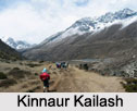 Garhwal Himalaya comprises of mountain ranges in the state of Uttarakhand. These mountain ranges are known to cross the Garhwal division and the Kumaon division. Garhwal Himalaya comprises of cities like Pauri, Tehri, Uttarkashi and Rudraprayag. It also comprises of hill stations like Nainital, Mussoorie, Dhanaulti and Bhimtal. Garhwal Himalaya comprises of mountain ranges in the state of Uttarakhand. These mountain ranges are known to cross the Garhwal division and the Kumaon division. Garhwal Himalaya comprises of cities like Pauri, Tehri, Uttarkashi and Rudraprayag. It also comprises of hill stations like Nainital, Mussoorie, Dhanaulti and Bhimtal.
Central Garhwal Himalaya Central Garhwal Himalaya comprises of the mountain area around the Saraswati-Alaknanda river system and the Dhauli Valley. The region has considerable significance in Hindu mythology. Kumaon Himalayas Kumaon Himalayas reclines next to the Garhwal region and is situated in the Great Himalayan Range. In fact, it is often confused with the Garhwal region itself. Kumaon region comprises the three districts of Nainital, Almora and Pithoragarh. This region is bordered by Mahakali in the east, towards Nepal and the districts of Chamoli and Pauri Garhwal in the west. Kinnaur Himalaya Kinnaur Himalaya comprises of a mountain in Kinnaur district in the state of Himachal Pradesh called Kinnaur Kailash. At its highest point, Kinnaur Kailash reaches a height of about 6050 meters (19,850 ft). This mountain is holy for Hindu and Buddhist Kinnauris. Eastern Karakoram Himalaya Eastern Karakoram Himalaya comprises of the Eastern Karakoram Range, which separates India from Central Asia. The mountain peaks like Saltoro Kangri, Rimo and Teram Kargri are parts of the range. This area offers ample scope for exploration as well as climbing. Sikkim Himalaya Sikkim Himalaya constitutes some part of the Eastern Himalayas, which is known for heavy rains. It is one of the more physically accessible sections of the Himalayan mountain range. It can be accessed from the state of Kolkata. Assam Himalaya The term Assam Himalaya was originally applied to the entire Himalayan chain that stretched eastwards from Pauhunri to Namcha Barwa. Unfortunately, the portion of the Himalayan Mountain range lies mainly in Bhutan and is properly called Bhutan Himalaya. The erstwhile mega-province of Assam has lost its Himalayan frontier to Arunachal Pradesh. Significance of Indian Himalayan Regions Himalayan Mountain chain of the Indian Himalayan Regions acts as a barrier against enemy attacks. It is known that this mountain chain has acted as a predominant factor in affecting the lives of the people who are living in the Indian Himalayan Regions. The mountain chain has been fascinating the inhabitants of the country for centuries. It has beautified the Indian Himalayan Regions and invites tourists, thereby playing an important role in the economy of the country. The regions of Indian Himalaya also offer trekking and mountaineering options to the tourists. |
| |||


Home > Reference > Geography of India > Indian Mountains > Himalayan Mountain Range > Indian Himalayan Regions
Indian Himalayan Regions
| Indian Himalayan Regions envelope most of the northern part of the country and these regions provide the travelers ample scope of exploring the huge Himalayan Mountain range. Some of these Himalayan regions are Kashmir Himalaya, Garhwal Himalaya and Kinnaur Himalaya. |
| ||||||||||||||||||||||||||||

