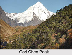
 The Gori Chen is a mountain peak, which forms a part of the Himalayas. More specifically, it is the most westerly of the major peaks of the Kangto section of the Assam Himalayan region. Assam Himalaya is a range of mountains located in the southeastern Tibet, Bhutan and the Indian states of northern Assam, Sikkim and Arunachal Pradesh. More specifically, Assam Himalaya is the name given to a portion of the Himalayan range of mountains situated between the eastern border of Bhutan on its western side and the Great Bend of the Tsangpo River on its eastern side. Namcha Barwa is the highest peak of this range of mountains. Himalayas in Bhutan as well as the Assam Himalayas are the least explored of the Himalayas. Himalayas in Bhutan and Assam have many unclimbed 6000 meters peaks. Characteristically, Gori Chen is a rock and ice peak. Mt Gori Chen has the distinction of being the 3rd highest peak in the north-eastern India, with the exception of Sikkim Himalayas. It also has the distinction of being the highest rock and ice peak of the Assam Himalayas.
Geography of Gori Chen Peak
The elevation of the Gori Chen Peak is debatable and under dispute. Different expeditions have measured different elevations of this mountain peak. As per the measurement of the Indian expedition on this mountain peak in the year 1994, the height of Gori Chen was revised from 6858 meters (22500ft) to 6488 meters (21286 ft). Other elevations have also been measured. Gori Chen has several subsidiaries and slightly lower peaks, which also have been climbed. This peak is also considered to be the headwaters of the Kameng River in Tawang.
History of Gori Chen Peak
Mt Gori Chen has been defined as a technical mountain peak, on which only the seasoned climbers can successfully reach its summit. There was an Indian Army Expedition which was organized to Mt. Gori Chen. Unfortunately in this expedition, two of the best mountaineers of this group lost their lives and the third member was severely injured while negotiating a climb between camp 11 and the summit camp.
Mt Gori Chen has been described as the most easily accessed of the main Arunachal peaks. Gori Chen peak has received major attention because of its proximity to inhabited localities to its south and its west. The Gorjo Chu rises beneath Gori Chen and is considered to be a natural approach route to the peak. This so called unpopular Tibetan trading route thereafter acquired the unjustified sobriquet of `the Bailey Trail`. However, no recce of Gori Chen was carried out. But in the year 1939, recce of the mountains of the Gori Chen area was carried out by an Englishman named Bill Tilman. Thus, Bill Tilman became the first man to attempt climbing in the remote and unexplored southern approaches of Gori Chen in the year 1939. Unfortunately, his team surrendered to malaria. Later on, a camp was sited higher up the Gorjo Chu, and Tilman carried out some plane-tabling from stations between 4800 meters and 5200 meters. In the year 1962, the Chinese Army came in strength down the Bailey Trail in a strategic stroke that destroyed the last Indian defenses of western North-Eastern Frontier Agency (N.E.F.A.). As part of the resurgence of activity following the debacle, an Army expedition under T. Haralu had set out in the autumn of the year 1966 for Gori Chen. The summit was reached on 29th October by Major J. C. Joshi, Captain N. Thapa, Lt A. J. B. Jaini, Lt N. P. Rajagopal, Nk. Mann Singh, L/Nk Darshan Singh, L/Nk Hira Bahadur and Gyamtsola. Post a successful ascent, the descent was marked by certain difficulties. A second ascent was also made on Mt. Gori Chen by an Indian Army expedition. The leader of this expedition was a person named Maj. A. Sen. In the year 1993, Gori Chen mountain peak was ascended by a team that was led by Dutchman Ronald Naar. Naar did not get the permission on time, owing to the then bureaucracy of the government and made an illegal ascent on the mountain. Today, Gori Chen is regarded as the most frequented of the Assam peaks.
Related Articles
Assam Himalaya, Indian Himalayan Regions
Indian Himalayan Regions
Himalayan Mountain Range, Indian Mountains
Indian Mountains