


 Krishna District has been named after River Krishna. The district was one of the oldest British administered areas of Andhra Pradesh. Machilipatnam is the administrative headquarter of the district and Vijaywada is known as the commercial center of the district. Krishna District has been named after River Krishna. The district was one of the oldest British administered areas of Andhra Pradesh. Machilipatnam is the administrative headquarter of the district and Vijaywada is known as the commercial center of the district.
History of Krishna District The history of the district dates back to the second century BC. Earlier Krishna district was known by the name Machlipatnam. When some taluks from the Guntur district was added to Machlipatnam in the year 1859 it was given the name Krishna. In 1904 Guntur district was separated from Krishna district and in 1925, the West Godavari district was also separated from Krishna district. Like many other districts of Andhra Pradesh, Krishna district has also witnessed the control of several rulers. Beginning with the Satavahana Kings, the district was ruled by the Pallavas, the Cholas, the Chalukyas, the Reddy’s, the Kakatiyas and even by the Nizams. In the year 1611, the Krishna district was finally taken over by the British. Geography of Krishna District The global position of Krishna district is between 15° 43’ and 17° 10’ north latitude and longitudinally it is placed between 80° and 81° 33’ east longitude. The district is spread across an area of 8,727 square kilometers. It has a coastline which is 88 kilometers long. The boundaries of the district are as follows Bay of Bengal and West Godavari district in the east, Khammam district in the north, Guntur and Nalgonda districts in the west and Bay of Bengal in the south. The important rivers of Krishna district are Krishna River, Muneru, Budameru and Tammileru. Similarly the main hill ranges of the region are Kondapalli, Jammalavoidurgam, Indrakiladri and Mogalrajapuram mountain ranges. The district has been divided into 50 mandals under four Revenue Divisions. The climate of Krishna district is of extreme type with severely hot summers and immensely cold winters. The hottest period experienced in the region is from April to June. The average rainfall of the area is 1028.1 mm. The type of soil that is most common in Krishna district is black cotton, red loam and sandy clay loam. The flora of the region is not known for dense forests. Only a few reserved forests are found in the district. A lightwood locally known as Ponuku or the Gyrocapus Jacquini is available on the Kondapalli hills. Some of the other common trees of the region are pterocarpus, Anogeissus, Casuarina, Terminalia and Logustroeinai. The fauna of the district includes panthers, fox, bear, jungle cats, spotted deer and black buck. A number of Murrah buffaloes and cows are found in the Krishna district as well. 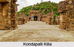 Demography of Krishna District Demography of Krishna District
Krishna district has a population of 4,187,841. Out of this population most of the people in Krishna district are rural based. Density of population in the district is as high as 479 persons per square kilometer. Population in the district grows by 14.05 percent every ten years. The literacy rate in the region has achieved a considerable height and it is equal to 70.03 percent. Education of Krishna District Krishna District is a well known seat of education in the entire state of Andhra Pradesh. Vijaywada, which is known as the commercial center of the district is the main center of education in Andhra Pradesh. The district serves as headquarter to several residential schools and colleges. Apart from these the district has several colleges giving degrees in medicine, engineering, arts and science subjects. It can be concluded that the Krishna district has no dearth of academic institutes. Economy of Krishna District The most common occupation among the people of Krishna district is agriculture. The urban population of the district is engaged with trade and commerce. Some of the important industries of the district are KCP Sugar Factory which is the largest sugar factory in the Indian sub-continent. The Vijayawada Thermal Power Station is also considered the best power plant in the country because of its excellent performance. Apart from these major industries there are several medium and small scale industries which include cement factories and manufacturing units of musical instruments. Kondapalli toys and Rold gold ornaments are also very common in the district and many people earn their living by selling or manufacturing them. Thus it can be understood that the main source of living for the people of Krishna district is agriculture and employment in various industries. Tourism in Krishna District Tourism in Krishna district has seen a synchronizing blend of religion and history. Some of the notable religious places in the district are Kanaka Durga Temple, Penuganchiprolu Temple, Muvva gopala swami temple, PandurangaSwamy Temple and Mopidevi Temple. The places which are of historical interest are Bandar Port, Gudivada, Gandhi Hill, Kondapalli killa and the Ghantasala. |
| |||


Krishna District
| Krishna District is located in the eastern part of Andhra Pradesh and was the oldest British administered area. |
| ||||||||||||||||||||||||||||

