Annupur is a sought after destination for a nature lover, pilgrim and an adventure seeker. This District came into existence on 15th August 2003.
Geography of Anuppur
Annupur district is situated in the northeastern part of Madhya Pradesh. The district is surrounded by Koria District in the east, Shahdol & Umaria District in the west, and Bilaspur in the south. The district extends 80 km from east to west and 70 km from north to south. It is a picturesque district with a belt of sal and mixed forests. The total geographical area of the district is 3701 sq. KM. Adjacent to the district are the boarding district of Bilaspur, Koria, Shahdol,Umarai & Dindori.
Annupur is predominantly a hilly district. From geographical point of view, the District consists of a series of mountain ranges and rivers.
It can be divided into three geographical divisions as:
•High lands of mountain ranges
•The Central plateau
•Low lands of rivers
 The rivers that flow through the district are Son, Johila, Narmada, Tipan, Bakan, Chandas and Kewai.
The climate of Annupur is temperate. It rains from June to October in the district. The temperature remains the highest in the month of June and the lowest in the month of January. The maximum and minimum temperatures of the district are 46 degree C and 2.6 degree C.
Division of Annupur
District Anuppur is divided into 4 tehsils, 04 janpads and 277 Gram Panchayats. There are 2 Municipalities and 4 Nagar Panchayats.
Demography of Anuppur
As per the 2001 census, the total population of Anuppur district is 667155, Out of which 309624 are Scheduled Tribes and 48376 are Scheduled Castes. Anuppur District is a Tribal Dominated District. Total literacy percentage of the district is 57.75, of which
69.55% are males and 45.45% are females.
Culture of Annupur
Annupur is a tribal dominated district. Their living standard is very simple. They live in houses that are made of mud, bamboo sticks, paddy straw and local tiles. The tribes wear dhoti, bandi, fatohi and headgear. The tribal women wear saree (kaansh saree). The saree they usually wear is body colored. They prefer painting their body parts hands, legs and neck. They wear different kinds of ornaments made of bamboo, seeds and metals.
Economy of Annupur
One third of the district is under forest cover and agricultural productivity is the region is low as a result of less availability of water. Occasionally, wheat & gram are cultivated where there is soil-moisture available. The main trees found in the district are sal, amla, teak, sarai and shisham. The mahua and guli flowers in the forests provide the people with edible oil. Tribal people mostly use Mahua flower for making wine.
The district is very rich in mineral resources as coal, bauxite and fire clay. Most of the coalmines are located in Kotma Sub Division. As per the 1998 Survey, there are 106 industries ( Large Scale & Small Scale ) in the whole District. The Orient paper Mill and Soda Factory are situated in Amlai. Small Scale industries of polythene and Baskets of Bamboo are also run in the District. There is a Bidi Factory in Venkatnagar.
94% villages of the District have been electrified.
The government of Madhya Pradesh is looking forward for developing land and water resources and also providing training for farmers in adequate agricultural practices.
Transportation of Annupur
Road is the main means of Transportation. Railway Facility is available for Katni , Chirimiri and Bilaspur route.
Places of interest in Annupur
The important places of interest are:
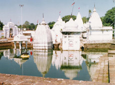 Narmada Mandir is a group of temples.
Mai Ka Bagiya is a garden, which lies in the densely forested area, lying 1km from the main temple.
Sonmuda or sunrise point is the point of origin of Sone River.
Kabir Chabutra is the place where St Kabir spent his time in meditation.
Jwaleshwar Mahadev is the point of origin of river Johilla.
Kapildhara is the place where Kapil rishi meditated.
Sarvodya Jain Temple is a temple under construction. Cement and iron have not been used in constructing this temple and the weight of the idol to be placed in the temple is around 24 Tones.
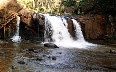
Shambhudhara & Durgadhara are extremely beautiful waterfalls located deep in the forest.
Narmada Mandir is a group of temples.
Mai Ka Bagiya is a garden, which lies in the densely forested area, lying 1km from the main temple.
Sonmuda or sunrise point is the point of origin of Sone River.
Kabir Chabutra is the place where St Kabir spent his time in meditation.
Jwaleshwar Mahadev is the point of origin of river Johilla.
Kapildhara is the place where Kapil rishi meditated.
Sarvodya Jain Temple is a temple under construction. Cement and iron have not been used in constructing this temple and the weight of the idol to be placed in the temple is around 24 Tones.
Shambhudhara & Durgadhara are extremely beautiful waterfalls located deep in the forest.


