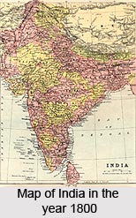
 With the advent of the British and with the involvement of the British intelligentsias developments in various sphere Development was witnessed in spheres like medicine, industry, natural science, art and architecture and even in geography. As such, developments in geography were gifted with talented brains. Use of sophisticated instruments and other innovative British measures made the natives look towards a fresh scientific age.
In 1789, the Madras Observatory was founded in order to make astronomical observations. Its measurements, associated with the eclipses of Jupiter`s satellites, assisted in determining of the observatory`s longitude. Developments in geography and other geographical arenas were a totally novel domain in Indian scenario, previously unheard to every native. And the fact that British had initiated such sophisticated system tools in guiding geographical contours was reason enough for the masters to fetch a better place.
In 1794, Michael Topping (1747-1796) established the first surveying school in India at Guindy in the Madras Presidency.
Within the years of 1799 to 1808, Colin Mackenzie (1754-1821) conducted a survey of Mysore and from 1799 to 1808 he served as Surveyor of Mysore. His survey used new standardised trigonometric techniques supported by astronomical observations. In addition to geographic features, Mackenzie`s survey of Mysore embraced the collection of information about cultivation, irrigation, markets, production and social/cultural and historical data.
In 1800, William Lambton (1756-1823) initiated the use of trigonometrical surveying techniques in Madras, making a significant impact on the accuracy on his measurements of meridional arcs.
Within the period of 1800 to 1801, Francis Buchanan (1762-1829) made a series of statistical and geographic surveys of Mysore and from 1807 to 1814 did the same for Bengal.
In the prolonged period of 1804 to 1823, in London, Aaron Arrowsmith (d. 1823) supported the East India Company`s needs for printed maps of India. His Improved Map of India (1816) and the Atlas of South India in Eighteen Sheets (1822) received high marks for their accuracy and uniformity.
On 3rd June 1814, the Court of Directors of the East India Company appointed Colin Mackenzie as the first Surveyor-General of India. On completion of his duties in Java and Madras, he took up his assignment in Calcutta in 1817. Developments in geography had picked up considerable velocity, with English minds working in unison to make Indian contours known to the world geographical society.
In 1818, Dr. Henry Wesley Voysey (1753-c. 1829) became the first officially appointed Company geologist to the Great Trigonometrical Survey of India. With Lambton and George Everest (1790-1866), he conducted tours of Hyderabad and central India investigating and collecting minerals and geologic specimens. He was the first to make a geological map in India and was also the first to report on the minerals and fossils found in the Deccan basalt in the Hyderabad locale. Voysey`s several reports were published in the Journal of the Asiatic Society of Bengal and his collection of specimens was placed in the Geological and India Museum in London.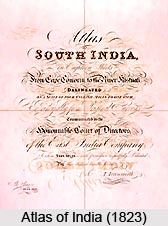
In 1820, John Crawfurd (1783-1868), member of the Company`s medical service, published his History of the India Archipelago, which defined Southeast Asia in geographic terms as a `tropical world`.
Developments in geography and geographical techniques welcomed additional boost when within the extensive time of 1823 to 1843, George Everest (1790-1866) was named the Superintendent of Great Trigonometrical Survey. From 1830 to 1843, Everest served as the Surveyor General of India. In 1835, he completed the Great Arc of India. From these surveys emerged the Atlas of India (1823) as published by the London cartographer, John Walker.
In the years within 1843-61, Andrew Scott Waugh (1810-1878) took the office of Surveyor-General of India. He completed an important series of triangulation maps for the north-eastern Himalayas the Punjab and Sind. Waugh broke tradition of designating mountain peaks by number and named the highest in the Himalayas after George Everest.
Within the period of 1861-78, Sir Henry Edward Lander Thuiller (1813-1906) served as the Surveyor-General of India. A proponent of completing the Atlas of India (1823-1906), he adopted hello and photozincography production techniques in lieu of lithography and modified the size of the Atlas to quarter sheets.
In 1870, J. T. Walker took existing plates and a group of British copper-engravers to establish a print shop in Calcutta, specifically in support of the needs of the Atlas of India.
From such promising accounts, it can smoothly be deduced that developments in geography under British hands did take a serious upward curve, that too when one is speaking of the early 18th - 19th century only. It can only be imagined what amount of geographical developments must have taken place in the later periods of British rule, though under much turbulence.