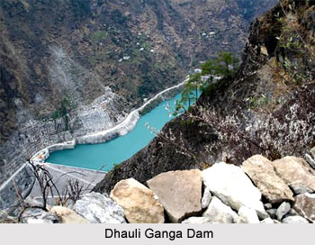
 The Dhauliganga Dam is under Dhauliganga Power Plant Project and is built in the Indian Himalayas in the border triangle between India, Nepal and China. The dam is raised to a height of about 56 metres and is a concrete-faced rock fill dam. The crown length of this dam is 270 m. The cut-off wall of Dhauliganga Dam is located at the upstream toe of the dam and it is built in the diaphragm walling process. The thickness of the dam is 1 metre and water reaches at a depth of about 70 m with a total area of 8000 m². The construction and functioning of the dam is supervised by the joint venture of Kajima Corporation (Japan) and Daewoo Corporation (Republic of Korea).
The dam axis is sited at a V-type valley with very steep side slopes. The rock layer is formed of biotite gneiss and augen gneiss with streaks of mica schists. The valley deposits are mainly fluvial deposits formed of sand and gravel with some streaks of marl type layers. The main characteristics of the bedrock of this Dhauliganga Dam is however are the presence of boulders throughout the whole valley section. The boulders are found at any depth with a size ranging from 20 cm to several meters.
This article is a stub. You can enrich by adding more information to it. Send your Write Up to content@indianetzone.com


