History of Mahanadi River, Indian River - Informative & researched article on History of Mahanadi River, Indian River
 Indianetzone: Largest Free Encyclopedia of India with thousand of articlesGeography of India


in  
 Art & Culture|Entertainment|Health|Reference|Sports|Society|Travel
Forum  | Free E-magazine  | RSS Feeds  
Geography of India : Indian Climate |Indian Mountains |Indian Forests |Indian Soil |Indian Vegetation |Animal Husbandry in India |Resources in India |Indian Demography |Indian Natural History |Indian Astronomy |Indian Industries |Indian Islands |Indian Airports |Zoos in India |Indian Mines and Minerals |Indian Physiography |Indian Transport |Indian Geology |Communication in India |Indian Trade |Indian Astronomers |Indian Telecommunications
Home > Reference > Geography of India > Resources in India > Water Resources in India > Indian Rivers > Himalayan Rivers > Mahanadi River > History of Mahanadi River
History of Mahanadi River, Indian River
The history of Mahanadi River refers to the birth of the river in Chhatisgarh and its significance.

 Mahanadi River at Boudh, Orissa
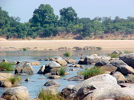
The Mahanadi rises in the highlands of Chhatisgarh. It flows across the Indian state of Orissa to reach the Bay of Bengal. The length of the river is around 860 km. Maharashtra, Chhattisgarh, Jharkhand and Orissa share its drainage basin. The Mahanadi River is a river of eastern India. The river is one of the longest rivers in India and drains a considerable part of peninsular India.

The world`s largest earth dam - the Hirakud Dam is built on the river and stands near the city of Sambalpur. It has a high tower, Gandhi Minar for check up of the dam; on other side of the dam another tower Ashok minar is constructed there.

The Mahanadi rises in Dhamtari District of Chhatisgarh. The productive plains of the Mahanadi valley are home to intensive rice cultivation. The Mahanadi and Brahmani rivers together form a large delta where they meet the Bay of Bengal. The city of Cuttack lies at the head of this delta. This delta features one of the largest mangrove forests in Indian peninsular, and is a main rice producing area of the eastern coast of India. The Mahanadi River irrigates a fruitful valley where crops of oilseed, rice, and sugarcane are cultivated.

This article is a stub. You can enrich by adding more information to it. Send your Write Up to content@indianetzone.com

(Last Updated on : 11/10/2010)
 
 
Geography of Mahanadi River Geology of Mahanadi River History of Mahanadi River
Mahanadi River Basin Mahanadi River Delta Mahanadi River System
Origin of Mahanadi River Religious Importance of Mahanadi River Tributaries of River Mahanadi
Course of River Mahanadi    
Recently Updated Articles in Geography of India
Trisuli Peak
Trisuli is situated at an elevation of 7,074 metres above mean sea level in the Pithoragarh district of Uttarakhand.
Suj Tilla East Peak
Suj Tilla East situated in the Pithoragarh district of Uttarakhand is a part of the Kumaon Himalaya division.
Siniolchu Peak
Siniolchu is one of the tallest mountains in Sikkim situated at a height of 6888 meters (22,598 feet).
Nun Kun Peaks
Nun Kun peaks are the two neighboring peaks of the Himalayan range, lying close to Jammu and Kashmir.
Nanda Kot
Nanda Kot is a mountain peak in the Kumaon Himalayan range .
E-mail this Article | Post a Comment
Forum
Forum on Geography of India
Free E-magazine
Subscribe to Free E-Magazine on Reference
 
 
History of Mahanadi River, Indian River - Informative & researched article on History of Mahanadi River, Indian River
Sitemap
Contact Us   |   RSS Feeds
Copyright © 2008 Jupiter Infomedia Ltd. All rights reserved including the right to reproduce the contents in whole or in part in any form or medium without the express written permission of
Jupiter Infomedia Ltd.