


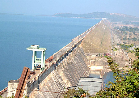
 Mahanadi River is about 885 km long that flows in central India. The river rises in Chhatisgarh State and flows eastwards through the Eastern Ghats Mountains before entering the Bay of Bengal through a delta near Cuttack, in the eastern state of Orissa. The Tel and Hasdo rivers are the major tributaries of River Mahanadi. The Hirakud Dam was constructed in1956 and it is the only large earthen structure at Sambalpur that regulates the flow of the Mahanadi and thus produces hydroelectricity. Mahanadi River is about 885 km long that flows in central India. The river rises in Chhatisgarh State and flows eastwards through the Eastern Ghats Mountains before entering the Bay of Bengal through a delta near Cuttack, in the eastern state of Orissa. The Tel and Hasdo rivers are the major tributaries of River Mahanadi. The Hirakud Dam was constructed in1956 and it is the only large earthen structure at Sambalpur that regulates the flow of the Mahanadi and thus produces hydroelectricity.
The flow of Mahanadi River is augmented by the drainage of hills to the north and south. At Sambalpur the Hirakud Dam on the river has constructed a man-made lake, which is 55 km long; the dam has several hydroelectric plants. Below the dam the Mahanadi river turns southwards along a meandering course, across the Eastern Ghats through a forest-covered gorge. Twisting in the eastward direction, the river enters the Orissa plains near Cuttack and thus enters the Bay of Bengal at False Point by a number of channels. The Mahanadi is also called the "Great River" because of its vast course of 560 miles (900 km). The river has an estimated drainage area of 51,000 square miles and it is one of the most active silt-depositing streams in the Indian subcontinent. The river supplies a number of irrigation canals, particularly near Cuttack and Puri, at one of its mouths, which is a famous pilgrimage site. This central Indian River rises in the hills of southeastern Madhya Pradesh state. Its upper course runs north as an insignificant stream, draining the eastern Chhatt?sgarh Plain. After the confluence with the Seon?th River, below Baloda B?z?r, the river turns east and enters Orissa state and thus its flow is improved by the drainage of hills to the north and southwards. At Sambalpur the H?r?kud Dam on the river has formed a man-made lake that is 35 miles long; the dam features several hydroelectric plants. Below the dam the Mah?nadi turns southwards along a meandering course, making its way though the Eastern Gh?ts through a deep, forested gorge. Bending towards the east, Mahanadi enters the Orissa plains near Cuttack and finally empties into the Bay of Bengal at False Point by several channels. |
| |||


Home > Reference > Geography of India > Natural Resources of India > Water Resources in India > Indian Rivers > Himalayan Rivers > Mahanadi River > Course of River Mahanadi
Course of River Mahanadi
| Mahanadi River course flows up to 885 kms surface area of India across the Eastern Ghats Mountains. |
| ||||||||||||||||||||||||||||

