Pushpawati River, Indian River - Informative & researched article on Pushpawati River, Indian River
  Indianetzone: Largest Free Encyclopedia of India with thousand of articles Geography of India


in  
Art & Culture | Entertainment | Health | Reference | Sports | Society | Travel
Forum  | RSS Feeds  | Free E-magazine
Geography of India : Indian Climate l Indian Mountains l Indian Forests l Indian Soil l Indian Vegetation l Animal Husbandry in India l Resources in India l Indian Demography l Indian Industries l Indian Islands l Indian Airports l Zoos in India l Indian Mines & Minerals l Indian Physiography l Indian Transport l Indian Geology l Communication in India l Indian Trade l Indian Astronomers l Indian Telecommunications
Home > Reference > Geography of India > Resources in India > Water Resources in India > Indian Rivers > Himalayan Rivers > Pushpawati River
Pushpawati River, Indian River
Pushpawati River begins in the Rataban and Nilgiri ranges and flows in the Deccan area.

Pushpawati River, Indian River
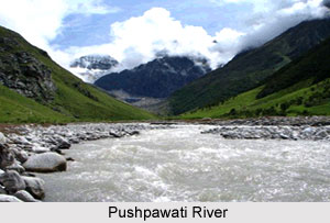
Pushpawati River originates from the glacial deposits around Rataban and Nilgiri ranges in Uttaranchal. It traverses across the Valley of Flowers dividing it into two sectors. A wide trace follows the Pushpawati River, first on the left and then on the right bank. At Ghangaria village the river converges with the Hemkund Ganga. Kundalinisen Plateau is located on the banks of this river. At Ghangharia, the Pushpavati River meets the Lakshman Ganga flowing from Hemkund.

This article is a stub. You can enrich by adding more information to it. Send your Write Up to content@indianetzone.com

(Last Updated on : 25/03/2009)
  More on Himalayan Rivers...
 
Ahar River Alaknanda River Ganga River
Yamuna River Manas River Gomti River
Indus River Narmada River Ghaggar River
Mahanadi River Tapti River Kali River
Luni River Bhagirathi River Banas River
Gambhir River Yashoda River Sabarmati River
Pushpawati River Patsari River Aner River
Ban Ganga River Palasini River  
Recently Updated Articles in Geography of India
  • Grand Trunk Road
    Grand Trunk Road is one of the oldest, longest and most important roads of South-Asia.
  •  
  • Types of Forests in India
    Elevation, topography, climate and soil type are the major factors which determine the type of forest.
  •  
  • Sispara Peak
    Sispara Peak is an Indian mountain peak, situated in the south Indian state of Tamil Nadu.
  •  
  • Indian Railway Zones
    Indian Railway network is classified into seventeen zones for administrative purposes.
  •  
E-mail this Article | Post a Comment
Free E-magazine
Subscribe to Free
E-Magazine on Geography of India

 
Pushpawati River, Indian River - Informative & researched article on Pushpawati River, Indian River
Sitemap
Contact Us   |   RSS Feeds
Copyright © 2008 Jupiter Infomedia Pvt. Ltd. All rights reserved including the right to reproduce the contents in whole or in part in any form or medium without the express written permission of Jupiter Infomedia Pvt. Ltd.