The Sabarmati River is a well-known river in Western India and is approximately 371 km in length. The Sabarmati River starts its journey in the Aravalli Range of the Udaipur District of Rajasthan. In the beginning of the course the river is also called as Wakal River. The majority course of the river flows in the Indian state of Gujarat. The river debouches in the Gulf of Cambay of Arabian Sea.
 Ahmedabad and Gandhinagar are the commercial and political capitals of Gujarat that were established on the serene banks of Sabarmati River. The legend goes in a way that Sultan Ahmed Shah of Gujarat, resting on the bank of Sabarmati, got inspired with the courage of a rabbit to chase a bully dog to found the city Ahmedabad in 1411.
Mahatma Gandhi established Sabarmati Ashram as his home on the banks of this river during India`s independence struggle. The origin of River Sabarmati is in the ranges of Aravalli and the river traverses a stretch of about 400 Km. Dharoi dam was built in 1973 at Dharoi located 85 Km towards the upstream of Ahmedabad.
It receives some excessive pollution pressure at Gandhinagar, owing to the construction of the Dam. The river Sabarmati usually carries only dry weather flow without any assimilative capability and starts stinking right at the beginning of the city since major storm water outlets discharges Sewage and Industrial waste waters. In the light of spread of urban area and chances of pollution of the River was decided to carry out survey covering maximum stretch under serious threat.
A total of 1033.17 ha were surveyed, which included a 10 km stretch of the river from the Sabarmati Railway Bridge at Dufnala up to one km downstream of Vasna Barrage. On the eastern region, the survey encompassed up to 100 m from the riverbank or up to the immediate major road on the western side. The final survey extended up to Ashram Road.
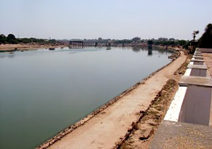
The Sabarmati river runs in a meandering pattern all along its course of about 9 kms from Subhash Bridge up to the Vasna Barrage through the city with an average width varying from 325 to 500 m. After surveying the configuration of the river, there are two indirect loops. Wherever the river has twisted or turned its course, the river ravine has widened due to scouring. This is clearly visible at Gaikwad Haveli and at Wadaj. The average reduced levels of the riverbed at Subhash Bridge that lies extreme north of the city and Vasna Barrage in the extreme south of the city are 39.2 m and 37.4 m respectively; the slope of the river is at the elevation of 1:5000. The height of the banks ranges from 4 to 9 mts.
A negative slope is formed from Sardar Bridge to Vasna Barrage. The edge is not clearly marked by embankments or retaining walls at most places. The river edge slopes in an undulating form down to the riverbed at several places, which have vegetation and have been intruded by slum settlements. The RL of the top gate of the Vasna Barrage is 41.756 m. Filling up the Vasna Barrage up to this level usually results in serious flooding of the nearby areas during the monsoons.


