Bawanthadi River, Indian River - Informative & researched article on Bawanthadi River, Indian River
  Indianetzone: Largest Free Encyclopedia of India with thousand of articles Geography of India


in  
Art & Culture | Entertainment | Health | Reference | Sports | Society | Travel
Forum  | RSS Feeds  | Free E-magazine
Geography of India : Indian Climate l Indian Mountains l Indian Forests l Indian Soil l Indian Vegetation l Animal Husbandry in India l Resources in India l Indian Demography l Indian Industries l Indian Islands l Indian Airports l Zoos in India l Indian Mines & Minerals l Indian Physiography l Indian Transport l Indian Geology l Communication in India l Indian Trade l Indian Astronomers l Indian Telecommunications
Home > Reference > Geography of India > Resources in India > Water Resources in India > Indian Rivers > Inland Drainage Basin > Bawanthadi River
Bawanthadi River, Indian River
The origin of Bawanthadi River is at the Kurai plateau of Seoni District in Madhya Pradesh.

Bawanthadi River, Indian River
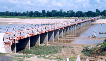
Bawanthadi River starts it journey from the Kurai plateau of Seoni District in Madhya Pradesh. Eventually, the river enters Bhandara District of Maharashtra by flowing towards south and functions as an interstate boundary between two states all along its middle course. Finally, the river merges with the Wainganga River after flowing for about 48 km. A dam is being built across this river at Sitekasa village of Maharashtra. Quicksand occurs in many parts of the riverbed of Bawanthadi River.

This article is a stub. You can enrich by adding more information to it. Send your Write Up to content@indianetzone.com

(Last Updated on : 25/03/2009)
  More on Inland Drainage Basin...
 
Mahi River Jaldhaka River Subarnarekha River
Shipra River Kameng River Vidarbha River
Teesta River Sindh River Sankh River
Rangeet River Pahuj River Kwari River
Koel River Kaliasote River Kali Sindh River
Bawanthadi River Brahmaputra River Budhi Gandak River
Damodar River Halali River Meghna River
Recently Updated Articles in Geography of India
  • Grand Trunk Road
    Grand Trunk Road is one of the oldest, longest and most important roads of South-Asia.
  •  
  • Types of Forests in India
    Elevation, topography, climate and soil type are the major factors which determine the type of forest.
  •  
  • Sispara Peak
    Sispara Peak is an Indian mountain peak, situated in the south Indian state of Tamil Nadu.
  •  
  • Indian Railway Zones
    Indian Railway network is classified into seventeen zones for administrative purposes.
  •  
E-mail this Article | Post a Comment
Free E-magazine
Subscribe to Free
E-Magazine on Geography of India

 
Bawanthadi River, Indian River - Informative & researched article on Bawanthadi River, Indian River
Sitemap
Contact Us   |   RSS Feeds
Copyright © 2008 Jupiter Infomedia Pvt. Ltd. All rights reserved including the right to reproduce the contents in whole or in part in any form or medium without the express written permission of Jupiter Infomedia Pvt. Ltd.