Navigation Along The River Narmada
|
Navigation along River Narmada has developed to its best in recent years.
|
|
|
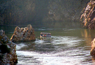 The river is presently partially navigable in the estuary reach around Bharuch. However, the river has never been a transportation artery. The idea for inland navigation came from NWDT thus giving its award for the two main dams, namely the Sardar Sarovar in Gujarat, built 180 km from the coast and the Narmada Sagar in Madhya Pradesh. These two dams are separated by a river with a distance of about 900 km, and the plans to build two other dams in between of the main stem of the river. A practical survey has been carried out for navigating the Narmada from the sea up to Hoshangabad - a distance of 639 km. Another survey was upto Jubbulpore a further distance of 309 km upstream. The main objective in these studies was to check the arrangements needed to be planned to discuss the Maheswar, Omkareswar, Indira Sagar and Sardar Sarovar projects. As such, the navigation choice is still open and probably can only be tracked after all the above dams are completed and other implications executed. The river is presently partially navigable in the estuary reach around Bharuch. However, the river has never been a transportation artery. The idea for inland navigation came from NWDT thus giving its award for the two main dams, namely the Sardar Sarovar in Gujarat, built 180 km from the coast and the Narmada Sagar in Madhya Pradesh. These two dams are separated by a river with a distance of about 900 km, and the plans to build two other dams in between of the main stem of the river. A practical survey has been carried out for navigating the Narmada from the sea up to Hoshangabad - a distance of 639 km. Another survey was upto Jubbulpore a further distance of 309 km upstream. The main objective in these studies was to check the arrangements needed to be planned to discuss the Maheswar, Omkareswar, Indira Sagar and Sardar Sarovar projects. As such, the navigation choice is still open and probably can only be tracked after all the above dams are completed and other implications executed.
This article is a stub. You can enrich by adding more information to it. Send your Write Up to content@indianetzone.com
|
|
|
|


