Geology of Narmada
|
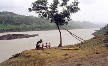
The geology of Narmada River depicts the soil composition of the river`s earth crust.
|
|
|
 The Narmada Valley is a graben. A graben means a layered block of the earth's crust that dropped down comparatively to the blocks on either side due to ancient spreading of the earth's crust. Two normal faults, known as the Narmada North fault and Narmada South fault, parallel to the river's course, and smear the boundary between the Narmada block and the Vindhya and Satpura blocks or horsts which rise relative to the Narmada Graben. The Narmada's watershed includes the northern slopes of the Satpuras, and the steep southern slope of the Vindhya Range; however, not the Vindhyan tableland and the streams from which flow into the Ganges and Yamuna. The Narmada valley is considered very significant for paleontological studies in India. Several dinosaur fossils have been found in this area including the Titanosaurus indicus that was found in 1877 by Richard Lydekker and the recently discovered one is that of the Rajasaurus narmadensis. The Narmada Valley is a graben. A graben means a layered block of the earth's crust that dropped down comparatively to the blocks on either side due to ancient spreading of the earth's crust. Two normal faults, known as the Narmada North fault and Narmada South fault, parallel to the river's course, and smear the boundary between the Narmada block and the Vindhya and Satpura blocks or horsts which rise relative to the Narmada Graben. The Narmada's watershed includes the northern slopes of the Satpuras, and the steep southern slope of the Vindhya Range; however, not the Vindhyan tableland and the streams from which flow into the Ganges and Yamuna. The Narmada valley is considered very significant for paleontological studies in India. Several dinosaur fossils have been found in this area including the Titanosaurus indicus that was found in 1877 by Richard Lydekker and the recently discovered one is that of the Rajasaurus narmadensis.
This article is a stub. You can enrich by adding more information to it.Send your Write Up to content@indianetzone.com.
|
|
|
|


