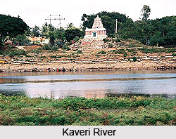
 The source of the Kaveri lies in the state of Karnataka, and the river flows in the direction of southeastward. The waters of the river have been an important source of irrigation since primitive days; as early as the early 1990s. Survey shows that around 95 % of the Kaveri was used for agricultural use before flowing into the Bay of Bengal. The delta of the Kaveri is so mature that the main river has almost lost its link with the sea, as the Kollidam, the distributary of the Kaveri is seen to possess most of the flow.
Coorg is the first beneficiary place receiving Kaveri`s benevolence and does her proud with lush vegetation. It is the land of sandalwood and cedar where betel vines hang gorgeously to the trees. Swaying with a grace typical of the area, areca palms and cardamom plants add spice to the exhilarating atmosphere. The jungles abound in wildlife. The vistas of the hills and valleys of Coorg are the spectacular views, which are a treat for nature lovers.
As Kaveri meanders westward beyond Kushalnagar and the first important memorial is that of Ramnathpura. Rama after killing Ravana is said to have worshipped the Eswara Linga situated here. A colonially flowing river and lush paddy fields creates a colorful canvas. The entire basin along the river Kaveri is very picturesque with high wooded hills and deep gorges lying at alternate areas with the plains of the river and her tributaries. Extremely beautiful idols of Sri Kodandarama and his companion decorate the temple at Chunchanakatte.
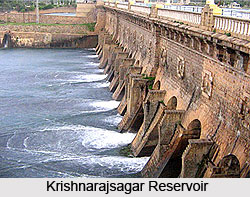
Kaveri now flows eastwards and deposits all its water in the Krishnarajsagar reservoir, which is built very close to Mysore. The reservoir features the world famous Brindavan Gardens. The dancing fountains and the countless colored lights turn this well laid out garden into a real dreamland in the dark hours. On the way to Srirangapatnam is the famous Ranganathittu bird sanctuary. Birds including white crane, darter, night heron, spotted pigeons and others flock to this place and often take a joy ride on the wet backs of the crocodiles lazing in the sun.
On the banks of the river and about 40 km from Mysore, lies Somnathpura, which is mainly known for its Lakshmikeshava temple. The devotees visit these temples for sure to see the Hoysala style of sculpture and architecture. The temples were constructed in AD 1268 by Soma, an officer in the court of Hoysala Mummadi Narasimha and this temple must be one of the most beautiful buildings in the world, superbly sculpted walls and intricate ceilings are spellbound combinations.
Along the course of River Kari, another well-known pilgrimage is Talakad. Kaveri changes her of flow in four ways, and in each of these vantage points stand temples dedicated to Shiva. These are the Panchlingeshwara temples located in huge mounds of sand in the Kaveri river basin. River Kaveri spreads ample mineral deposits and water over a vast tract of land and then falls down in form of a gigantic waterfall at Sivanasamudram whose hydroelectric potential has been used.
The loud roar with which River Kaveri tumbles down at Gaganchukki and Barachukki silences the spectators into a speechless awe. She then touches the southern border of Bangalore district and enters the Tamil Nadu through an extremely narrow passage rightly called Meke Datu, or the goat`s leap. Her tributaries are Kanva and Arkavathi swell up her ranks here. In Karnataka, Kaveri has granted immense agricultural prosperity to Tiruchi and Tanjore districts of Tamil Nadu through fertility of soil.
As the last tract of her journey, Kaveri empties her water at the Bay of Bengal at Kaveripupattinam, one year after her emergence at Bagamandala and lends authority to the Hindu theory of rebirth by beginning her journey all over again on Tula Sankramana.


