


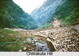
 Chitrakuta, also spelt Chitrakoot, is an isolated hill situated in the Madhya Pradesh state of India. Chitrakuta is located fifty miles south-east of the town of Banda in Bundelkhand. This hill is linked with Lord Rama who is one of the many popular deities in Hinduism. In addition to this, Chitrakuta hill is home to various ancient temples, tranquil forest glades and quiet rivers. This place draws the attention of the pilgrims and tourists throughout the year. Chitrakuta, also spelt Chitrakoot, is an isolated hill situated in the Madhya Pradesh state of India. Chitrakuta is located fifty miles south-east of the town of Banda in Bundelkhand. This hill is linked with Lord Rama who is one of the many popular deities in Hinduism. In addition to this, Chitrakuta hill is home to various ancient temples, tranquil forest glades and quiet rivers. This place draws the attention of the pilgrims and tourists throughout the year.
Etymology of Chitrakuta Hill The term Chitrakuta means the 'Hill of many wonders'. Religious Places of Chitrakuta Hill Chitrakuta hill's association with various Indian mythological stories makes it more popular among the tourists. Chitrakuta is one of the oldest pilgrimages in the country. It is a sacred spot crowded with temples and shrines of Lord Rama and Lakshmana. It is believed that Lord Rama and Sita spent eleven of their fourteen years of exile in the dense forests of this hill. There is also a belief that Rama had taken a dip at Ramghat with Lakshman and Sita on their arrival at Chitrakuta. And Ramghat presently is one of the most pleasant bathing ghats in Chitrakuta which is positioned at the centre of town. It is also renowned for being the seat of Valmiki, the sage and poet famous as the author of the Ramayana. Again, this is the place where the principal trinity of the Hindu pantheon, Brahma, Vishnu and Mahesh, took their incarnations. 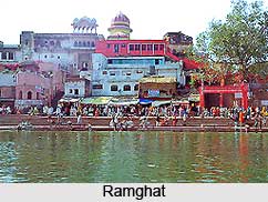
Chitrakoot is located in the northern Vindhya Mountain Range spread over the adjacent states of Uttar Pradesh and Madhya Pradesh. Chitrakoot Parvat Mala comprises Kamad Giri, Janki Kund, Lakshman pahari, Hanumaan Dhara, and Devangana. These are all famous mountains having religious significance. This peculiarly shaped mountain also has many caves that are worth visiting. Chitrakoot Dham is the name of a nearby town. This place is known as a centre of large number of temples and sites that are mentioned in various Hindu scriptures. Devotees from all parts of the country gather here on the occasion of Amavasya. Some of the special occasions of such huge celebrations and gatherings are Somwati Amavasyas, Diwali, Sharad-Poornima, Makar Sankranti and Ramnavami. The hill also houses some ashrams including the Valmiki Ashram, Sutikshna Ashram and Sati Anusuya Ashram that are popular religious places of the area. Other places of interest are Pramod Van, Janaki Kund, Ram Shaiyya, Sphatik Shila, Bharat Milap Mandir, Bharat Koop, Shabari Fall, Param Kutir, Hanuman Dhara, Viradh Kund and Lakshman Chowki. |
| |||


Home > Reference > Geography of India > Indian Mountains > Himalayan Mountain Range > Chitrakuta Hill
Chitrakuta Hill
| Chitrakuta hill is defined as an isolated hill situated on a river called the Pisani. It means the Hill of many wonders. |
| ||||||||||||||||||||||||||||

