


 Meghna River Meghna River
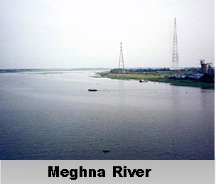
The Meghna River, originating from the hilly regions of eastern India, has long been a vital source of water supply and livelihood in the undivided Bengal region. Following the partition of India in 1947, the river assumed even greater significance as one of the primary water resources in Bangladesh. As one of the three rivers forming the Ganges Delta, the Meghna River boasts the distinction of being the largest delta in the world. Formation and Course of Meghna River The Meghna River takes shape entirely within the boundaries of Bangladesh, formed by the confluence of various rivers originating from the hilly areas of eastern India. Above Bhairab Bazar, the Surma and Kushiyara rivers merge, giving birth to the Meghna. This upper stretch of the river is referred to as the Upper Meghna. Upon joining forces with the Padma River in Chandpur District, the river transforms into the Lower Meghna. Finally, the Meghna flows into the Bay of Bengal in Bhola District, marking the end of its journey. Tributaries and Distributaries of Meghna River The Meghna River is not just a solitary waterway; it receives contributions from several tributaries that enhance its flow and significance. One of the notable tributaries is the Titas River, which emerges from the Meghna near Chatalpar in Brahmanbaria District. After meandering through two large bends, the Titas rejoins the Meghna near Nabinagar Upazila. The Gumti River also joins the Meghna in Daudkandi, Comilla District, further reinforcing its water volume. These tributaries, along with the Dhaleshwari River before Chandpur, play a crucial role in sustaining the Meghna's strength. Moreover, the Meghna River itself acts as a distributor of water as it fans out to the Bay of Bengal. It forms four principal mouths, namely Tetulia (Ilsha), Shahbazpur, Hatia, and Bamni, through which it empties into the bay. These distributaries facilitate the river's connection with the vast ocean, shaping the distinctive ecosystem of the Ganges Delta. Features of Meghna River The Meghna River holds some fascinating features that set it apart. It is the widest river entirely contained within the borders of Bangladesh, reaching a width of 13 kilometers near Bhola. In its lower reaches, the river exhibits an almost perfectly straight course. As the Meghna River approaches the Bay of Bengal, it braids into several smaller rivers such as Pagli, Katalia, Dhonagoda, Matlab, and Udhamodi. These rivers branch out from the Meghna but eventually reunite downstream. Just before reaching the bay, the river divides into two main streams within the Ganges delta, creating a separation between an island and the mainland. The western stream, known as Ilsha, and the eastern stream called Bamni, contributes to the Meghna's distinction as one of the widest rivers in Bangladesh and the world. The confluence of the Padma River and the Jamuna River, along with the joining of the Meghna in Chandpur District, marks a significant point in the Lower Meghna's journey. The confluence of the brown and hazy water from the Padma River with the clear water of the Upper Meghna creates a mesmerizing sight. As the two streams flow parallel to each other, half of the river appears transparent while the other half retains its brown color. This unique phenomenon captures the attention of visitors and adds to the allure of the Meghna River. Challenges of Meghna River Despite its seemingly calm appearance, the Meghna River poses risks and challenges. Over the years, it has been responsible for numerous casualties, with ferry accidents claiming the lives of hundreds. The vicinity near Chandpur is particularly notorious for its dangerous waters. Navigating the Meghna River is not without its challenges. While it is a navigable waterway, its depth and velocity make it treacherous, posing risks to those who traverse its waters. Additionally, during spring tides, a powerful tidal bore can surge upstream, reaching heights of nearly 20 feet (6 meters). These natural forces remind us of the power and unpredictability of the Meghna River, necessitating caution and respect when venturing along its course. Ecological significance of Meghna River The Meghna River, with its origin, course, tributaries, and distributaries, remains a lifeline for Bangladesh. It not only provides a vital source of water for irrigation, drinking, and other domestic purposes but also supports the livelihoods of countless people who depend on fishing and agriculture. The river's ecological significance cannot be overstated, as it nurtures a diverse range of flora and fauna, contributing to the region's rich biodiversity. Moreover, the Meghna River holds cultural and historical significance for the people of Bangladesh. It has witnessed the ebb and flow of civilizations, serving as a witness to the nation's heritage. The bridges spanning the Meghna and its tributaries, such as the Gumti River, stand as engineering marvels, connecting communities and facilitating trade and transportation. |
| |||


Home > Reference > Geography of India > Natural Resources of India > Water Resources in India > Indian Rivers > Inland Drainage Basin Rivers > Meghna River
Meghna River
| The Meghna River is one of the most important rivers of Bangladesh and eastern India. Originating from eastern India, this mighty river traverses through the Ganges Delta, connecting with tributaries and forming a sprawling network of waterways. |
| ||||||||||||||||||||||||||||

