|
 The Ganges Basin with its fertile soil is influential to the agricultural economies of India and Bangladesh. The Ganges and its tributaries provide a constant source of irrigation to an extensive area. The major crops cultivated in that area include rice, lentils, sugarcane, potatoes, oil seeds and wheat. Along the banks of the river, the existence of swamps and lakes provide a rich fertile area for crops like legumes, chilies, sesame, mustard, sugarcane, and jute. There are also many fishing zones along the river, though all of them are highly polluted. The Ganges Basin with its fertile soil is influential to the agricultural economies of India and Bangladesh. The Ganges and its tributaries provide a constant source of irrigation to an extensive area. The major crops cultivated in that area include rice, lentils, sugarcane, potatoes, oil seeds and wheat. Along the banks of the river, the existence of swamps and lakes provide a rich fertile area for crops like legumes, chilies, sesame, mustard, sugarcane, and jute. There are also many fishing zones along the river, though all of them are highly polluted.
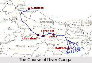
The geography of Ganga River is closely associated with its religious significance. Since the origin of the River is in Gangotri, most of the towns along the river are considered to be pilgrimages of the Hindus. Three towns along the river are thought to be the holiest of all towns in the country. Haridwar, Allahabad, and Varanasi attract thousands of pilgrims to its waters. Thousands of Hindu pilgrims arrive at these towns to take a dip in the Ganges, which is believed to purify oneself of sins and help to accomplish salvation. The rapids and waterfalls of the Ganges also are popular for river rafting, attracting hundreds of adventure lovers in the summer months.
The river waters start getting polluted right at the source. The commercial exploitation of the river has risen as the population has risen. Gangotri and Uttarakashi are good examples of excessively polluted River Ganges. Gangotri had only a few huts of Sadu's until the 1970's. The population of Uttarakashi has increased heavily in recent years. As it flows through highly densely inhabited areas the Ganges collects large amounts of human pollutants, like the Schistosoma mansoni and faecal coliforms. Eventually, drinking and bathing in its waters have become highly risky and may carry infection. While proposals have been made for re mediating this condition, negligible progress has been achieved in the field.
The Ganges River's long held reputation, as a purifying river seems to have a basis in science. The river water has an exclusive and extraordinary ability to retain oxygen, but the reason for this ability is not known. According to a report in a National Public Radio program, Dysentery and cholera are diminished, preventing large-scale epidemics. A UN Climate Report issued in 2007 have mentioned that the Himalayan glaciers that feed the Ganges may evaporate by 2030, after which the river's flow would be a seasonal occurrence only during the months of monsoons.
|
|
|
|
Articles you would like to read with Geography of Ganga River
|
|
|
|
| • | Origin of Ganga River
The origin of Ganga River is Gangotri Glacier. Ganga is the holiest river in India.
| | |
|
|
|


