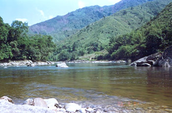
 The Bhareli River is presently known as the Kameng River and flows in Arunachal Pradesh and Jia Bhoreli in Assam. The river originates in the eastern Himalayan Mountains, in Tawang district from the glacial lake below snow capped Gori Chen Mountain. The exact location of the origin of Bhareli River is 27°48?36?N, 92°26?38?E, which is at an elevation of 6,300 metres or 20,669 ft on the India-Tibet border in South Tibet and flows through Bhalukpong circle of West Kameng District, Arunachal Pradesh and Sonitpur District of Assam, India.
The Bhareli River is one of the chief tributaries of the Brahmaputra River, merging it at Tezpur, east of the Kolia Bhomora Setu Bridge. The Bhareli River forms the margin between East Kamemg District and West Kameng Districts and is also the frontier between the Sessa and Eagle nest sanctuaries to its west and the Pakke tiger reserve in the east. The Dafla Hills fall on the east of the Aka Hills, which is the home of Aka tribe fall the west of the Bhareli River. The entire forest zone along the Bhalukpong-Bomdila highway fall on the west bank of the river in West Kameng has vanished in the last few years though the forest across the river continues to be in a vigorous flow.
The eastern part of Eaglenest-Sessa Wildlife sanctuaries is shattered by the Tippi Naala or Tippi River, which joins Bhareli river at the village of Tippi on the Bhalukpong-Bomdila highway. The other major rivers in the West Bhareli District, the Tenga, Bichom and Dirang Chu, are also tributaries of the Bhareli.
This article is a stub. You can enrich by adding more information to it. Send your Write Up to content@indianetzone.com


