


 The city, Jaisalmer has a plethora of beautiful locales, which can easily enchant the minds of tourists who visit quite often. The curiosity of discovering city with its bounty develops a curiosity amongst the people to gain acquaintance with the details of the geography of Jaisalmer city. The city, Jaisalmer has a plethora of beautiful locales, which can easily enchant the minds of tourists who visit quite often. The curiosity of discovering city with its bounty develops a curiosity amongst the people to gain acquaintance with the details of the geography of Jaisalmer city.
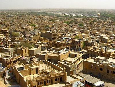
Strategically, Jaisalmer is places approximately at 26.92° N 70.9° E. it also rises to a height of about 229 meters or 751 feet above the mean sea level. In fact Jiasalmer lies on Indo- Pakistan border at western part of Rajasthan state. It covers a total area of about 5.1 sq. km. Climatic condition too helps one to identify the geography of Jaisalmer city in better way. Climate is dry and humid. During summer , temperature rises as high as 41.6 °C . Minimum temperature has been marked to be 25 °C. Winter are chilly and freezing. Maximum temperature ranges to The 23.6 °C . Minimum temperature even drops down to as low as 7.9 °C. The Jaisalmer city witnesses an average rainfall of about 150 mm. Few facts about the geography of Jaisalmer city also are penned down. Being a part of Great Indian Desert Jaisalmer is strewn with sandy waste. This area is full with sand hills of varied shapes and sizes. Some of them even rise to as high as 150 feet. In the western side several sand hills are found which are encircled with large bushes. Hills in the eastern side are covered with tracts of huge grass. No discussion about geography of Jaisalmer city is complete with discussing about its water bodies. So far as rivers are concerned, one finds no such perennial river in the Jaisalmer city. Only a tiny river flows up to a distance of nearly 28 meters and after that it stretches to a huge surface of flat ground and forms a lake or jhil. River is called Kakni, while the jhil that is formed is named as Bhuj-Jhil. Scanty rainfall is not suitable for irrigation. Only rain crops like joar, bajra, motif, til, etc., are produced. ; Spring crops like wheat, barley, etc., are rarely grown. Due to scarcity of water wells are built whose average depth is about 250 ft. Knowledge of demographical details also enables one to know the geography of Jaisalmer. In this regard a special mentioning may be made of the Census report of a particular year. Being issued forth in the year 2001 it throws light on certain facts like population status, literacy rate etc. According to this report, Jaisalmer has showed a total count of 58,286. Out of it, male populace constitutes 57 %, while the population of females comprises of 43 % only. Literacy rate too acts vital information about the geography of Jaisalmer. As per this report, average literacy rate of Jaisalmer has been enumerated to be 64 %, which is even higher than India, which constitutes 59.5 %. To be specific, male literacy constitutes 73 %. However rate of female literacy is only 50 %. In Jaisalmer, children who are below six years of age constitute 16 % of the total population. Majority of the population has adapted to the life of a nomad. They used to graze their stocks of animals. They also nurture herds of big animals like camels, horned cattle, sheep and goats. For sustaining their livelihood, people used to carry on trading activities. Things that are put on sale are wool, ghee and also animals like sheep, cattle, and camels. Principal items for import include grain, sugar, foreign clothes and goods. |
| |||


Home > Travel > Indian Cities > Cities of India > Cities of Rajasthan > Jaisalmer > Geography of Jaisalmer
Geography of Jaisalmer
| The Golden city, Jaisalmer is a locale, which intermixes the heritage of its past history and its picturesque beauty. |
| ||||||||||||||||||||||||||||

