 Swargarohini is a mountain massif, which is a part of the Bandarpunch Range of the Garhwal Himalaya. It is located in the Uttarkashi district, west of the Gangotri group of peaks, in the north Indian state of Uttarakhand. This mountain massif consists of four separate peaks out of which Swargarohini I is the main peak. This peak is notable for its steepness and challenging climb. It has two summits, east and west. The west summit is at an elevation of 6252 metres (20,512 feet) above mean sea level. The east summit is slightly lower than the west summit and is located at an elevation of 6247 meters (20,495 feet) above mean sea level. The geographic coordinates of this peak are 31 degree 05 04 North, 78 degree 30 58 East. This snow-clad peak is the source of the Tonk River and along with the Bandarpunch massif it acts as a divider between the Yamuna and the Bhagirathi Rivers.
Mythological Story of Swargarohini
The name of this peak is derived from the mythological story associated with it. It is said that the peak forms the path which leads to heaven and this route was followed by Pandavas, Draupadi and their Dog. As per legends, this is the only route one can go to heaven with human body itself.
Climbing History of Swargarohini
It is very difficult to climb this peak and as of 1994, total fifteen attempts had been made. The first attempt of the west summit of Swargarohini I was made in the year 1974 from the west side. The first ascent was made in the year 1990 by a team of instructors from the Nehru Institute of Mountaineering. The first attempt of the south face was made in the year 1991 though it was unsuccessful. Eventually, the first undisputed ascent of the peak came in the year 1993 via this face.
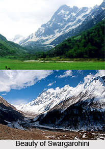
Attractions of Swargarohini
However, due to its amazing beauty and religious significance, the vicinity of Swargarohini is quite popular among the trekkers. The peak is surrounded by myriad beautiful flowers and lush greenery. There is a river, many small streams and a glacier in the surrounding of Swargarohini. The remarkable feature of the peak is it actually looks like steps when it is fully covered by snow.


