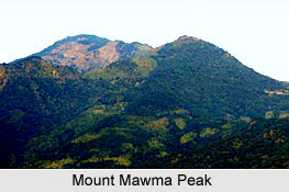
 Mount Mawma Peak is situated in the Mizoram state of India. Mount Mawma is the fifth highest mountain peak in the state. It is the highest mountain peak in the Mara Autonomous District Council and is located in the eastern part of the district. Mount Mawma Peak is considered as a "paradise for nature lovers". Mount Mawma is quite popular with the mountaineers. Every year, adventure lovers from different corners of the world flock to this peak to explore its amazing beauty.
Location of Mount Mawma Peak
Mount Mawma is located in the north-eastern state of India, Mizoram. It is situated at a height of 6370 feet (1941.57) above mean sea level and is positioned next to Mount Tliatlu which is the second highest mountain peak in Mara Autonomous District Council.
Attractions of Mount Mawma Peak
Situated in the south-eastern part of Mizoram, the mountain is fifteen kilometres from India"s international boundary with Myanmar. Myanmar and India are separated by the River Koldyne which flows below this mountain. At a distance of two kilometres from Mount Mawma lies the Chakhei town. During the winters, the plains of Bangladesh and several parts of western Myanmar are visible from the hill. The peak also provides a beautiful view of many Burmese villages across the border. Rare and wild flowers like Rhododendrons bloom in the hill slopes throughout the year and this makes Mount Mawma a paradise for nature lovers. The suitable time for mountaineering is September and October.
This article is a stub. You can enrich by adding more information to it. Send your Write Up to content@indianetzone.com


