 Kumara hills or Kumara Parvata is a part of the Western Ghats situated at a height of 1712 metres in the Karnataka state of India. This mountain is on the boundary line between the Dakshina Kannada district and the Kodagu district. It is located at a distance of ninety seven kilometres from Hassan and one hundred and three kilometres from Mangalore.
Religious Significance of Kumara Hills
The hills are popular among the pilgrims due to its religious significance. It is situated in Subramanya village of Sullia taluka and forms an imposing backdrop of the Kukke Subramanya Swamy Temple. Many devotees visit this shrine throughout the year.
The white stones found on top of the Kumara Parvata are called Kumaralingas and they have six faces. These stones are regarded as Saligramams and Shivlings. There are no paths which reach the peak. In order to reach Kumara Parvata, one has to climb Sesha Parvatha.
Attractions of Kumara Hills
The whole region falls under the Pushpagiri Wildlife Sanctuary which is home to some rare and endangered birdlife. This sanctuary is designated as one of the important bird areas of the world. The hills are surrounded by various points that are worth visiting. Amidst the hills, there is a place called Girigadde, where one can find a four pillared construction called as Mantapa. There are two other beautiful peaks that lie near to Kumara Parvata namely Siddha Parvata and Shesha Parvata.
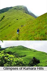
Trekking at Kumara Hills
The mountain is well known for trekking as it offers exciting opportunities to trekkers. It is often referred to as a trekker"s paradise. However, trek to Kumara Parvatha is also considered to be one of the most challenging treks in Karnataka. Many start the trek trail from Kukke Subramanya town in Dakshina Kannada district. It can also be approached from Somwarpet town in Kodagu district. The trek distance from Kukke Subramanya is 14km. At the starting, the path from Kukke Subramanya passes through thick vegetation which houses various species of poisonous snakes.
And in order to trek from Somwarpet side one has to reach the peak via a village named Bidalli. From Bidalli it takes around 13km to reach the top. While trekking from this route, people might have to experience mud road and steep rocks. September to February is the ideal time to trek the hills.


