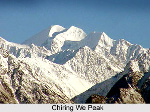
 Chiring We Peak is a Himalayan peak situated in the Uttarakhand state of India. It is the highest peak above Kalabland Glacier. The terms Chiring We literally mean `mountain of long life`. The peak was first scaled in the year 1979 by an Indian team lead by mountaineer and author Harish Kapadia via northeast ridge.
Location of Chiring We Peak
Chiring We is located in the Pithoragarh district of Uttarakhand. It is situated in the eastern Kumaon division. It is positioned at an altitude of 6,559 metres above mean sea level. The geographic coordinates of this mountain is 30 degree25`12 North, 80 dehree18`00 East.
Attractions of Chiring We Peak
The beauty of this peak attracts many mountaineers and explorers throughout the year. At 21,520 feet, Chiring We is one of the highest mountain peaks in the area. The Chiring We massif consists of peaks like Bamba Dhura at a height of 6,334 metres, Suli Top at a height of 6,300 meters, Trigal at a height of 5983 metres and Suitilla at a height of 6373 meters above mean sea level. This peak separates Lassar Yankti valley from the Kalabaland Valley.
Chering We is accessible through glaciers of Kalabaland, Sankalpa and Yankchar, icefall, crevasses, ice summits, ice walls and pointed ridges.
This article is a stub. You can enrich by adding more information to it. Send your Write Up to content@indianetzone.com


