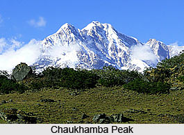
 Chaukhamba is a mountain massif in the Gangotri Region of the Garhwal Himalaya. The mountain ridge of Chaukhamba forms the part of Gangotri group that are part of Garhwal Himalayas. Chaukhamba, meaning four pillars is the highest mountain group of the Western Garhwal. Chaukhamba as the name denotes, has four summits along the north east - southwest trending ridge. The highest peak that is part of this entire range is named as Chaukhamba I. This highest peak is named as the chief peak of the Gangotri Glacier and is the prominent part of the eastern range of the entire group. The location of this peak is majorly towards the state of Uttarakhand. The peak is also part of holy city of Badrinath. It has assumed religious significance as it lies at the head of the holy Gangotri glacier. On the western slopes starts the Gangotri glacier; one of the largest in the Himalayas (excluding Karakoram). The Gangotri glacier gives rise to the Bhagirathi which is one of the two main sources of the holy River Ganga. At the end of the Gangotri glacier is a better-known mountain: Shivling Peak. The Shivling peak is another important mountain of this group.
Elevation of the Chaukhamba Range
The four major pinnacles of the Chaukhamba can be named as northeast-southwest crest and elevates to a range of 7138 m to 6854 m whereas the average elevation of the mountain range is 7014 m. The major cliff is located towards the northeast end. The mountain prominence (it is a measure of vertical separation between mountains) of Chaukhamba is 1,594 m (5,230 feet).
•Chaukhamba I is 7138 m
•Chaukhamba II is 7070 m
•Chaukhamba III is 6995 m
•Chaukhamba IV is 6854 m
Mountaineering at Chaukhamba Peak
After unsuccessful attempts in 1938 and 1939, Chaukhamba I was first climbed on June 13, 1952, by Lucien George and Victor Russenberger. The path covered by them was from the northeast end that included Bhagirathi glacier and the Kharak glacier. The major pass of this mountain range is the Mana Pass and Chaukhamba I has been declared as major peak that has an eminence of almost 1500 m.


