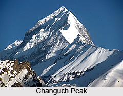
 Changuch Peak is a Himalayan mountain peak situated in the Uttarakhand state of India. Changuch Peak is one of the star attractions in Uttarakhand. The peak is technically a dangerous mountain which does not provide any simple route to the Summit. Despite being a tough mountain, it keeps on inviting explorers every year from different parts of the world. And attempts of accessing this peak never dies. Changuch was first successfully scaled by an Indo-British team in the year 2009.
Location of Changuch Peak
The peak is situated at the borderline between the districts of Pithoragarh and Bageshwar in the northern state of India, Uttarakhand. This Himalayan mountain peak is situated in the Kumaon region of Uttarakhand. The peak is nestled above the Pindari Glacier. It is positioned at an altitude of 6322 m in the mountain ranges of the Himalayas. The geographic coordinates of the mountain are 30 Degree 17`24 North, 80 Degree 02`24 East.
Attractions of Changuch Peak
The peak offers a ridge, which leads to the majestic Nanda Kot, which is situated at a height of 6,861 metres above, mean sea level. On the massif of the Changuch Peak there is a Traill`s pass which links Pindari valley to the Goriganga valley. The peak can be approached from Song (RH), Lohar, Khet - Dhakuri and Khati.
This article is a stub. You can enrich by adding more information to it. Send your Write Up to content@indianetzone.com


