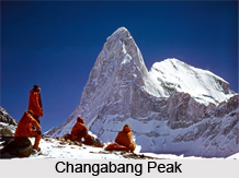
 Changabang Peak is a granite mountain peak situated in the Uttarakhand state of India. Changabang is regarded as India`s hardest mountain and is a part of the Himalaya in the Garhwal Division. Its steep rocky profile made it the site of many significant climbs. It was first scaled in the year 1974 by an expedition led by Lt. Col Balwant Sandhu and Chris Bonington.
Location of Changabang Peak
Changabang Peak is located in the northernmost part of the Nanda Devi Sanctuary in Uttarkhand. It is positioned at an altitude of 6,864 metres (22,520 feet) above mean sea level.
Features of Changabang Peak
Changabang is a steep and rocky peak and does not have a high topographic prominence. It is lower than Kalanka, which is situated in the east and is lower than many other peaks situated nearby.
In terms of height, it is 18, 406 ft / 5, 610 m mountain peak. It ranks as the 8th highest mountain in Uttarakhand and the 35th highest mountain in India.
Despite the tough challenges, Changabang Peak`s beauty has attracted many climbers to the spot. Famous mountaineer Frank Smythe described it in 1937 as "a peak that falls from crest to glacier in a wall that might have been sliced in a single cut of a knife".
In 1982, environmental concerns have prohibited entry to the Nanga Devi Sanctuary which stopped climbing to the peak. However, in 1996 the peak was re-opened with limited climbing access.
Accessibility of Changabang Peak
The peak is accessible from the rocky Rishi Ganga gorge or from Lata via Dharansi Pass. The nearest airport is the Jolly Grant Airport in Dehradun and the nearest railway station is at Rishikesh.
This article is a stub. You can enrich by adding more information to it. Send your Write Up to content@indianetzone.com


