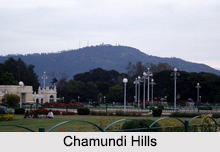
 Chamundi hills have developed themselves as a major tourist spot in South India. The hills are among the eight most sacred hills of South India. They stand as crown jewel of Mysore and are the consecrated seat of gods and goddesses. The hills are home to various ancient temples one of which is the temple of Chamundeshwari. It is believed that the city of Mysore derived its name from the demon king Mahishasura and Goddess Chamundi is the presiding deity of the city and the Maharajas of Mysore. Every year, the hills attract tourists and devotees from various parts of the country.
Location of Chamundi Hills
The hills are located in the Karnataka state of India. They are situated at a distance of ten kilometres from Mysore which is a prominent city in Karnataka. The hills are situated at an average elevation of one thousand metres above mean sea level.
 Attractions of Chamundi Hills
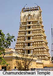
The two thousand year old Chamundeshwari (an incarnation of Goddess Parvathi) Temple, exemplifying the Dravidian school of architecture is located right on top of the hill. The unique feature of the temple is a statue of Mahishasura. The statue is exhibited with a sword in his right hand and a cobra in the left. One will also find a sculpted depiction of the Goddess Chamundeshwari in standing position within the temple`s sanctum. The temple can be accessed by cars. One can also walk there by climbing one thousand steps.
On the mid way to the temple there is a sixteen foot monolith statue of Nandi carved in granite. Near the Chamundi hills there is another famous temple, the temple of Mahabaleshwar. The Mahabaleswara Ishwara which is in the form of a Linga is the oldest temple on the hill. One can get a panoramic view of the city from the Chamundi hills.
Connectivity of Chamundi Hills
The Chamundi hills are well connected via road. The buses are regularly administered from Mysore`s central bus station to Chamundi hills. On demand other vehicles like taxi can also be availed. Also KSRTC Volvo buses frequently ply between Mysore and Chamundi hills.


