The Tapti
River, also known as Tapi River is located in central India and runs following an east to west itinerary, between two rivers namely, the
Godavari and
Narmada. It journeys through
Surat and is crossed by the Magdalla ONGC
Bridge. Along this river there are several places of interest. There are major towns along the river, which are situated in the Indian
states of
Madhya Pradesh,
Maharashtra and
Gujarat. More specifically, these towns are Multai, Nepanagar and
Burhanpur in Madhya Pradesh, Surat and Songadh in Gujarat and Bhusawal in Maharashtra.
Multai : Multai is located on the northern bank of the river Tapti. It is one of the southern cities of Madhya Pradesh. More specifically, it can be defined as a small town and a Nagar Palika in the district of Betul. Multai covers almost half of the
Satpura plateau.
Sanskrit word for Multai is Multapi, which stands for origin of Tapti River. Multapi is known to be the initial name of the city, Multai. It was therefore named after the river Tapti. It has an average elevation of about 749 meters (2457 feet).
Forests lie to the west of the city between the districts of
East Nimar and Amaraoti. Multai was one of the regional headquarters connecting the district headquarter in the north to the district headquarter,
Nagpur in Maharashtra, during the
Maratha regime and
British rule in India.
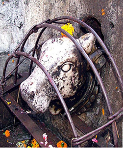
Multai is a holy place and a home to two
temples namely, Prachin (old) Mandir and Naveen (new) Mandir. Both these temples are dedicated to Mata Tapti. According to
Hindu mythology, Mata Tapti is known to be the daughter of
Surya, the Sun God. Akhad Saptami Tapti Janmotsav is known to be celebrated in this town. The Multai town is bedecked and an annual mela is also held on this occasion. This town is known for many ancient Hindu Temples, where
Lord Shiva and
Hanuman are worshipped.
The city has people belonging to different religions and following different traditions and cultural practices. Bundelkhandi
language and culture has been identified in the northern part of the town. The southern part of the town is known for the presence of
Marathi Language and Maharastrian culture. The rest of the town is prominently occupied by
tribal population, known as the
Gonds and
Korkus. They believe in Bada Mahadev. They are known to also believe in superstitions and animal sacrifice as a ritual is associated with them. They depend on natural
herbs for healthcare and medication.
Burhanpur : Burhanpur is situated on the north bank of the Tapti River, on the southwestern border of Madhya Pradesh. More specifically, it is about 340 kilometers (211 mi) southwest of
Bhopal and about 540 kilometers (336 mi) northeast of
Mumbai. It can be defined as a mid-size city and an administrative seat of Burhanpur district. It has a municipal corporation and also is one of the district headquarters of the state of Madhya Pradesh.
Burhanpur is well known for
textile industries. It is the largest hub for power loom industry in Madhya Pradesh. Burhanpur has several places capable of attracting a plethora of tourists.
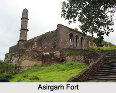
Asirgarh Fort,
Jama Masjid,
Swami Narayan Temple,
Ganesh Temple, Dargah-e-Hakimi and Shahi Qila are some of the places attracting the attention of tourists.
Nepanagar : Nepanagar is an industrial township located in Burhanpur district. More specifically, this small township lies between Burhanpur and
Khandwa and has many small
villages in its surrounding. The name of this town is partially derived form the word "NEPA", which stands for National Environment Protection Authority.
A noteworthy attraction of this small town is the newsprint paper mill called the Nepa Mills Limited (earlier known as The National News Print Ltd). The Nepa Mill is known to occupy total land area of about 1869 acres. There are about 2164 residential quarters in the township, belonging to the Nepa Mills.
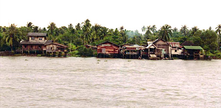
Surat : Surat is the administrative capital of the Surat district. The city centre is located about 22 km (14 mi) south of the Tapti River. The city is located about 284 kilometers (176 mi) south of the state capital,
Gandhinagar; about 265 kilometers (165 mi) south of
Ahmedabad; and about 289 kilometers (180 mi) north of Mumbai. Surat was earlier known as Suryapur. It has an elevation of about 13 m (43 ft). Surat has a tropical savanna
climate moderated strongly by the sea to the Gulf of Cambay. Surat is well known for its relaxed lifestyle and its cuisine.
Surat itself has various centers of attraction for its visitors. Bank of River Tapi has a place of interest called the Tapi River Front at Adajan. The
Sardar Patel Museum is a home to a collection of over 10,000 specimens of arts and crafts. It was established in the year 1998 and was originally called the Winchester Museum. Heritage Square and Surat Castle or Surat Fort is known to be a historical castle. It was planned and built between 1540 and 1546 by Khudawand Khan. Presently, it is located in the Chowk Bazar area in Surat. It is one of the chief ancient
monuments of Surat. Chintamani
Jain Temple is located in the Shahpor area. It is known to be constructed in the 15th century. Noteworthy features of this temple are
wooden carvings, extremely rare
paintings of the Jain monk, Acharya
Hemachandra and of the
Solanki King,
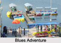
Kumarpal. Blues Adventures is a recreational and adventure project, inaugurated in January 2013 by the then Chief Minister of Gujarat, Mr. Narendra Modi. It is known for
water-sports activities,
amusement park and restaurants. It is located at the basin of River Tapti (Tapi) on the Singanpore side of Weir-cum-Causeway in Surat.
Jagdishchandra Bose Aquarium, also known as Surat Aquarium, Gavier
Lake, Dr.
Shyama Prasad Mukharjee Surat Municipal
Zoo or Sarthana Nature Park Science Centre, the Dutch Cemetery, Navinchandra Mafatlal Garden are some of the other places of attraction in Surat.
Songadh : Songadh is a municipal corporation in the
district of Tapi. The main town of Fort Songadh is situated on Highway 6 with
Nandurbar district to its east and Vyara (district headquarters) to its west. More specifically this town is located at the foot of a solitary hill. Son stands for
Gold and Gadh stands for
fort. Thus, Songadh means the `Fort of Gold`. This main town is divided into two other towns called Junagam (old town) and Navagam (new town). It has an average elevation of 112 meters (367 feet).
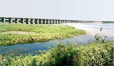
Ukai
Dam, Swarnim Tapi Van,
Parshuram Temple, Hindustan Bridge, Rokadiya Hanuman Temple,
Gaumukh, Dosvada Dam-Rani Mahal, the Central Pulp Mills, quarries located around Songadh and the TPS and Hydro power station are the places of interest in Fort Songadh.
Bhusawal : Bhusawal or Bhusaval is a city and a municipal council, established in 1882 in
Jalgaon district. More specifically, this city is situated on
National Highway 6. It is considered to be the biggest taluka of Jalgaon district. It has an average elevation of 209 meters (685 feet).
Bhusawal is well known for the cultivation of
banana. This place is frequented by traders from various parts of the country for the purpose of buying raw bananas. There is also international export of these bananas. Bhusawal is also well known for its special white brinjals. Cultivation of these brinjals takes place in the nearby areas. They are a part of the delicacies in local marriages, apart from daal baati toop (a lentil dish served with ghee) and peanut garlic chutney. Bhusawal is also popular in whole of Jalgaon district for two items namely, Banducha Vada-Pav and Ghasilal Vada-Pav. Excursions in Bhusawal can be organized to the Thermal Power Station of Maharashtra State Electricity Board (Deepnagar), Orient Cement Grinding Unit, Ordinance Factory (Bhusawal and Varangaon), Indian Oil Corporation Limited Depot and
Railway`s Zonal Training School.
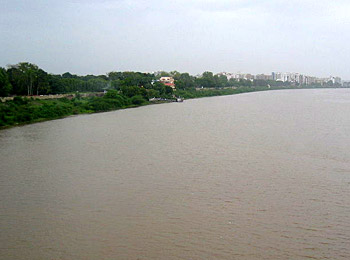
 Tapti River is one of the major rivers in central India. It is one of the three rivers (the other two being, Narmada River and Mahi River), which flows in east to west direction. The Tapti River drains through the Gulf of Khambhat into the Arabian Sea. The river flows through the state of Surat, and is crossed by the Magdalla ONGC Bridge.
 There is a Purana mentioning the virtues of Tapti extensively and it praises the river as more sacred than all other rivers including the Ganges.
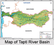
 Tapti river is one of the major rivers in India and flows in the central part of India. The river originates from the Betul district of Madhya Pradesh in the Satpura range at an approximate height of about 752 meter above the sea level. The Tapti River flows through the Indian states of Maharashtra, Gujrat and Madhya Pradesh. Apart from the Narmada River, Tapi is the only river, which flows in the westward direction and empties into the Arabian Sea. The Tapi basin extends to the total area of 65, 145 sq km that is approximately 2.0% of the total geographical area of India. The main tributaries of the Tapi River are Purna, The Panjhra, The Vaghur, The Girna, the Bori and the Aner.
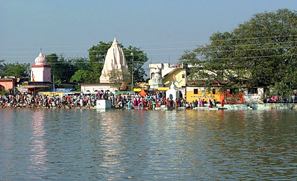
 The origin of Tapti River is at the Satpura range of Betul district in the central Indian state of Madhya Pradesh. It is supposed to originating from small pond at a small town known as Multai, originally known as Multapi or the origin spot of Tapti. The Betul District encompasses an area of 10043 km² and population is around 13,95,175 as per 2001 census. The place Multapi has become a tourist spot and also a place for pilgrimage for the worshippers of Tapti River. Density of the population in this town is 138/km². Betul district is actually rich in tribal population. The tribal population of the district as per 2001 census is 5,49,907. The main tribes inhabiting the district are Gonds and Korkus. The other castes of tribe in this place include Kurmis, Bhoyars, Mehras, Kunbis, Chamars, Banias and Rajputs.
 The climate of Betul or the place of Tapti River`s origin is fairly healthy. Its height above the plains and the neighborhood of widespread forests moderate the heat, and render the warmth pleasant throughout most of the part of the year. During the winter season the temperature at night falls below the freezing point. Rarely hot wind is felt before the end of April. The summer nights are comparatively cool and pleasant. During the monsoon the climate becomes very damp, and at times even cold and raw, bulky clouds and mist envelops the sky for many days together. The average annual rainfall of the place is 40 in.
 The Tapti River rises in Madhya Pradesh. The Vindhya Range includes the north central and northwestern boundary of the Peninsula; also the Chota Nagpur Plateau of southern Bihar forms the northeastern boundary of the Tapti River basin. The uplifting of the plateau of the central Peninsula and its eastward tilt formed the Western Ghats, a line of hills running from the Tapti River south to the tip of the Peninsula. The Eastern Ghats mark the eastern end of the Tapti plateau; the river begins in the hills Multapi and converges with the Western Ghats at the Peninsula`s southern tip.
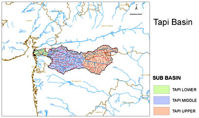
 The Tapti River basin covers an area of 65,145 km² that makes up almost two percent of the total area of India. The basin lies in the states of Maharashtra, coveri8ng an area about 51,504 km², Madhya Pradesh with 9,804 km² surface area and Gujarat covering 3,837 km² of land. The basin lies mostly in the northern and eastern districts Maharashtra state, including Amravati, Akola, Buldhana, Washim, Jalgaon, Dhule, Nandurbar, and Nashik districts, but also includes the Betul and Burhanpur districts of Madhya Pradesh and the Surat district of Gujarat.
 The basin mostly lie in the northern and eastern districts Maharashtra state, including places like Amravati, Dhule, Akola, Washim, Buldhana, Nandurbar, Jalgaon and Nashik districts. However, the Betul and Burhanpur districts of Madhya Pradesh and the Surat district of Gujarat are the prime districts included in the Tapti River basin.
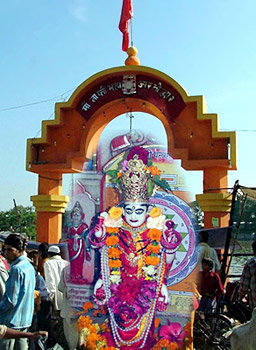 According to the legends, Tapti River is the daughter of Surya or the Sun God. Some says that Surya has given birth to the Tapti River in order to save himself from his own intense heat. The river is also widely mentioned in the great Indian epic Mahabharata, according to which Tapti married Sanvaran, who is a legendary hero of the moon dynasty. Tapti and Sanvaran also had the son and named him Kuru. It was on his name only the Kuru dynasty started. Tapi is known as the Goddess among the Hindus and is worshiped religiously among them.