


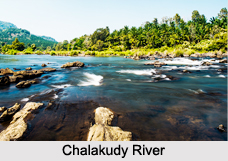
 Chalakudy River is located in the Indian state of Kerala. It is also known by the name of Chalakudy Puzha. This river is actually considered to be a collection of some of the major tributaries originating from Parambikulam, Kuriyarkutti, Sholayar, Karapara and Anakayam in Kerala. It has received the status of being the fourth longest river in Kerala. Chalakudy River is located in the Indian state of Kerala. It is also known by the name of Chalakudy Puzha. This river is actually considered to be a collection of some of the major tributaries originating from Parambikulam, Kuriyarkutti, Sholayar, Karapara and Anakayam in Kerala. It has received the status of being the fourth longest river in Kerala.
Geography of Chalakudy River Globally, the source of Chalakudy River can be pinpointed at coordinates 10 degrees 22 minutes 00 seconds north and 77 degrees 07 minutes 30 seconds east. The mouth of this river can be pinpointed at coordinates 10 degrees 09 minutes 44 seconds north and 76 degrees 15 minutes 56 seconds east. Geologically, this river is considered to be a tributary of the Periyar River. In this regard, it is important to note that it is for all the practical purposes due to which the Chalakudy is treated as a separate river by the government and other agencies. This river has an elevation of about1, 250 m (4,101 ft). It has a length of about 145.5 km (90 mi) and a total drainage area of about 1,704 km2 (658 sq mi). More specifically, 1404 km sq. of the total drainage area lies in Kerala and the rest 300 km sq. lies in Tamil Nadu. Due to this very reason, Chalakudy is considered to be more a Kerala river than that of Tamil Nadu. The average discharge of Chalakudy at its mouth is 52 m3/s (1,836 cu ft/s). Course of Chalakudy River The Chalakudy River rises from the Anamalai Hills. Thus, Anamalai Hills is the source of the Chalakudy at Kerala-Tamil Nadu Border. In Kerala, this river flows through Palakkad district, Thrissur District and Ernakulam District. It then amalgamates with the Periyar River, near Puthanvelikkara, adjacent to Manjali, North Paravur in Ernakulam District. Thus, the Periyar is considered to be the mouth of Chalakudy River. It then meets the Kodungallur Backwaters and joins the Arabian Sea at Azhekode. Tributaries of Chalakudy River During its journey, as the Chalakudy River branches out, it forms a geographical feature named tributary. This river has several tributaries on its right. These tributaries are Karappara River, Kuriarkutty Aar, Peruvarippallam Aar, Thunacadavu Aar and Sholayar River. Of these, the Parambikulam River is considered to be the most important. These tributaries are all located in the Chalakudy town. Flora of Chalakudy River The riparian forests of the Chalakudy River are known for the existence of the thick riparian vegetation. This vegetation occupies an area of about 58.5 hectares and has a width of more than 10 metres for a stretch of about 10.5 km downstream from Peringalkuth. More specifically, about 26.4 hectares of this vegetation lie within the Vazachal area, inclusive of the three large islands that are thickly covered by riparian forests. These forests are also a home to the evergreen species, semi-evergreen species and typical riparian species of plants. As per estimations, about 319 species of flowering plants have been identified in the forest area. It is important to note that 24 such species are known to be endemic and belong to the Western Ghats, whereas 10 such species are labelled as rare and endangered. It is again important to note that according to a report of the National Bureau of Fish Genetic Resources in Lucknow, the Chalakudy River could be the richest river in fish diversity in India, with thick vegetation on both sides. Fauna of Chalakudy River The Chalakudy River is diverse in terms of it’s fish population. The fish of this river is considered to be of the best quality and taste. Out of the 152 species known to be found in Kerala, the Chalakudy is a home to about 98 species of fresh water fishes. As per estimations, about 35 such species are endemic and belong to the Western Ghats. More specifically, 11 species of the Western Ghats are vulnerable, 16 such species are endangered and 4 such species are critically endangered. The respective conditions of the different species mentioned above are attributed to indiscriminate collection for the aquarium fish trade, overfishing, pollution and construction of dams. Among the fish species in the river, the most species rich family are the Cyprinids, followed by Bagrid catfishes and hill stream loaches. Sahyadria chalakkudiensis is an endemic species of cyprinid fish in the Chalakudy River. The Chalakudi is also a home to fishes that were earlier labelled as extinct. Utilization of Chalakudy River The Chalakudy River is a very useful water body for the state of Kerala. The Thumboormoozhy dam has been built across Chalakudy. This dam helps in preserving water and is also useful for irrigation purposes. Under the Sholayar Hydro Electric Project and Peringalkuttu Hydro Electric Project, the hydro electric projects on the Chalakkudy River, generation of electricity became a possibility. The state of Kerala is blessed with this generated electricity. It is the features of Chalakudy River that helps in the generation of electricity. They are the high level of water, the speed with which the water flows from the river rotating the turbines and its natural water currents. The Chalakudy River is also a tourism product of Kerala. It is known to be a source of revenue to the tourism industry of Kerala. Two famous waterfalls namely, Athirappilly Falls and Vazhachal Falls are situated on the Chalakudy, they have the potential to attract tourists to Chalakudy River. Its economic significance also lies in the export of huge amount of fish not only to other states of India but also outside India. Related Articles: Water Resources in India Indian Rivers Himalayan Rivers Coastal Rivers Inland Drainage Basin |
| |||


Home > Reference > Geography of India > Natural Resources of India > Water Resources in India > Indian Rivers > Deccan Rivers > Chalakudy River
Chalakudy River
| Chalakudy River has its origin in the Anamalai region of Tamil Nadu with a total drainage area of 1704 square kilometres. |
| ||||||||||||||||||||||||||||

