 Ranchi District is one of the administrative districts of Jharkhand with its headquarters at Ranchi town. Ranchi District is situated at 23 degrees 23 minutes north latitude and 85 degrees 23 minutes east longitude. The total area occupied by Ranchi District is 7574.17 sq kms and average elevation of Ranchi District is 2140 feet above the sea level. The total number of educational blocks in Ranchi District is around 24. Educational institutions in Ranchi are very famous and Ranchi has many educational institutions. Administration of Ranchi District is headed by a Deputy Commissioner. Administrative Setup in Ranchi is divided into Ranchi and Bundu subdivisions and each subdivision is further divided into blocks, Panchayats and villages. Moreover, administrative set-up of Ranchi District includes 14 development blocks and these are Angara, Burmu, Bero, Chanho, Kanke, Lapung, Mandar, Namkum, Ormanjhi, Ratu, Silli, Bundu, Sonahatu and Tamar.
History of Ranchi District
Ranchi District has an earlier the name called Lohardaga. The old district came into existence after the creation of the non-regulation south - west frontier as a result of the rising of the Kol Tribe in 1831-32. The name of the district was changed in 1899 from Lohardaga District to Ranchi after the name of a small village now comprised within the headquarters station. In ancient times, the tract which corresponds to the district of Ranchi and the neighbouring Parganas was in the undisturbed possession of Munda Tribe and Oraon tribe and was known to Aryans as Jharkhand or the `forest territory`.
Geography of Ranchi District
Ranchi District mainly experiences three seasons in a year namely summer, winter and rainy seasons. The temperature varies, like in winter the minimum temperature is 10.3 degree Celsius and maximum temperature is 22.9 degree Celsius while in summer season minimum temperature is 20.6 degree Celsius and maximum temperature is 37.2 degree Celsius. The annual average rainfall is 1530. Some minerals are also found in Ranchi district. But the main ones are limestone, coal, asbestos, and ornamental stones, etc. The important crops cultivated in the region include rice, millets pulses and oilseeds. Some important rivers that flow through the district are mainly Subarnarekha River, Koel River and Sankh River.
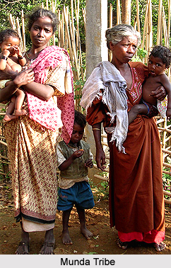
Demography of Ranchi District
The main tribes of the Ranchi District are Oraon tribe and Munda tribe. Hindi language, Nagpuri, Oraon, Mundari and Kurmali are the main languages spoken in the district. The population density is 362 per sq km. According to the Population Census in the year 2011, Ranchi District had population of 2,912,022 of which male and female were 1,493,376 and 1,418,646 respectively. The population of Ranchi District constituted 8.83 percent of total population of Jharkhand. In 2001 census, this figure for Ranchi District was at 8.72 percent of Maharashtra population. The population density of Rachi District shows 557 people per sq. km.
The average literacy rate of Ranchi in 2011 was 77.13 percent compared to 66.71 percent of 2001. If things are looked out at gender wise, the male and female literacy rates were 85.63 percent and 68.20 percent respectively. The total literate in Ranchi District were 1,946,738 of which male and female were 1,107,238 and 839,488 respectively.
Tourism in Ranchi District
Ranchi is also called the city of waterfalls, forests and lakes. Dassam fall is 34 kms from Ranchi on Ranchi-Tata Road near a village called Taimara. Here, the Kachni River falls from an altitude of 144 feet. It is also known as Dassam Gagh, a natural cascade.
Roadways, airways as well as railways connect Ranchi District with other parts of the country. NH-33 and NH-23 connects the district very well.


